Bern, Kansas
Bern is a city in Nemaha County, Kansas, United States.[1] As of the 2010 census, the city population was 166.[5]
Bern, Kansas | |
|---|---|
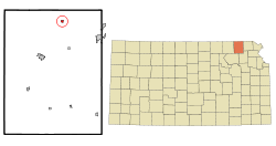 Location within Nemaha County and Kansas | |
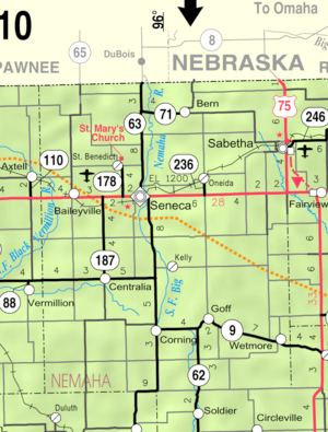 KDOT map of Nemaha County (legend) | |
| Coordinates: 39°57′44″N 95°58′19″W[1] | |
| Country | United States |
| State | Kansas |
| County | Nemaha |
| Incorporated | 1910 |
| Named for | Bern, Switzerland |
| Area | |
| • Total | 0.29 sq mi (0.75 km2) |
| • Land | 0.29 sq mi (0.75 km2) |
| • Water | 0 sq mi (0 km2) |
| Elevation | 1,280 ft (390 m) |
| Population | |
| • Total | 166 |
| • Estimate (2016)[4] | 166 |
| • Density | 570/sq mi (220/km2) |
| Time zone | UTC-6 (CST) |
| • Summer (DST) | UTC-5 (CDT) |
| ZIP code | 66408 |
| Area code | 785 |
| FIPS code | 20-06275 [1] |
| GNIS ID | 0472747 [1] |
History
Bern had its start in the late 1880s by the building of the railroad through that territory.[6] It was named by Swiss immigrants after Bern, the capital of Switzerland.[7][8]
Geography
Bern is located at 39°57′44″N 95°58′19″W (39.9622218, -95.9719422).[1] According to the United States Census Bureau, the city has a total area of 0.29 square miles (0.75 km2), all of it land.[2]
Demographics
| Historical population | |||
|---|---|---|---|
| Census | Pop. | %± | |
| 1930 | 306 | — | |
| 1940 | 236 | −22.9% | |
| 1950 | 216 | −8.5% | |
| 1960 | 206 | −4.6% | |
| 1970 | 191 | −7.3% | |
| 1980 | 220 | 15.2% | |
| 1990 | 190 | −13.6% | |
| 2000 | 204 | 7.4% | |
| 2010 | 166 | −18.6% | |
| Est. 2016 | 166 | [4] | 0.0% |
| U.S. Decennial Census | |||
2010 census
As of the census[3] of 2010, there were 166 people, 81 households, and 45 families residing in the city. The population density was 572.4 inhabitants per square mile (221.0/km2). There were 95 housing units at an average density of 327.6 per square mile (126.5/km2). The racial makeup of the city was 91.0% White, 0.6% African American, 3.0% Native American, 3.0% from other races, and 2.4% from two or more races. Hispanic or Latino of any race were 6.0% of the population.
There were 81 households of which 21.0% had children under the age of 18 living with them, 48.1% were married couples living together, 4.9% had a female householder with no husband present, 2.5% had a male householder with no wife present, and 44.4% were non-families. 40.7% of all households were made up of individuals and 16% had someone living alone who was 65 years of age or older. The average household size was 2.05 and the average family size was 2.73.
The median age in the city was 43.5 years. 18.7% of residents were under the age of 18; 10.1% were between the ages of 18 and 24; 22.8% were from 25 to 44; 28.2% were from 45 to 64; and 19.9% were 65 years of age or older. The gender makeup of the city was 51.8% male and 48.2% female.
2000 census
As of the census[9] of 2000, there were 204 people, 86 households, and 55 families residing in the city. The population density was 748.7 people per square mile (291.7/km²). There were 102 housing units at an average density of 374.4 per square mile (145.9/km²). The racial makeup of the city was 99.51% White, and 0.49% from two or more races. Hispanic or Latino of any race were 1.96% of the population.
There were 86 households out of which 37.2% had children under the age of 18 living with them, 55.8% were married couples living together, 3.5% had a female householder with no husband present, and 34.9% were non-families, and 24.4% had someone living alone who was 65 years of age or older. The average household size was 2.37 and the average family size was 3.02.
In the city, the population was spread out with 27.5% under the age of 18, 6.4% from 18 to 24, 26.0% from 25 to 44, 21.6% from 45 to 64, and 18.6% who were 65 years of age or older. The median age was 40 years. For every 100 females, there were 92.5 males. For every 100 females age 18 and over, there were 85.0 males.
The median income for a household in the city was $40,417, and the median income for a family was $49,000. Males had a median income of $34,063 versus $21,563 for females. The per capita income for the city was $16,254. About 7.4% of families and 7.1% of the population were below the poverty line, including 5.6% of those under the age of eighteen and 5.7% of those sixty five or over.
Education
It is within Prairie Hills USD 113,[10] formed in 2010 by the merger of Sabetha USD 441 and Axtel USD 488.[11]
Notable person
See also
- Tornado outbreak of May 20–22, 2019
References
- Geographic Names Information System (GNIS) details for Bern, Kansas; United States Geological Survey (USGS); October 13, 1978.
- "US Gazetteer files 2010". United States Census Bureau. Archived from the original on 2012-07-02. Retrieved 2012-07-06.
- "U.S. Census website". United States Census Bureau. Retrieved 2012-07-06.
- "Population and Housing Unit Estimates". Retrieved June 9, 2017.
- "2010 City Population and Housing Occupancy Status". U.S. Census Bureau. Retrieved July 2, 2011.
- Tennal, Ralph (1916). History of Nemaha County, Kansas. Standard Publishing Company. pp. 116.
- Kansas State Historical Society (1916). Biennial Report of the Board of Directors of the Kansas State Historical Society. Kansas State Printing Plant. pp. 249.
- "Profile for Bern, Kansas". ePodunk. Retrieved 18 June 2014.
- "U.S. Census website". United States Census Bureau. Retrieved 2008-01-31.
- "USD 273 Map" (PDF). Kansas Department of Transportation. Retrieved 2020-04-29.
- "School consolidations in Kansas for past decade". The Topeka Capital-Journal. 2011-07-24. Retrieved 2020-04-26.
External links
- City
- Schools
- USD 113, local school district
- Maps
- Bern City Map, KDOT
Municipalities and communities of Nemaha County, Kansas, United States | ||
|---|---|---|
| Cities | 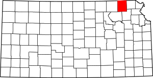 Map of Kansas highlighting Nemaha County | |
| CDP | ||
| Unincorporated communities | ||
| Footnotes | ‡This populated place also has portions in an adjacent county or counties | |