Glasnevin
Glasnevin (Irish: Glas Naíon, meaning "stream of the infants", also known as Glas Naedhe, meaning "stream of O'Naeidhe" after a local stream and an ancient chieftain) is a neighbourhood of Dublin, Ireland, situated on the River Tolka. While primarily residential, Glasnevin is also home to the National Botanic Gardens, national meteorological office and a range of other State bodies, and Dublin City University has its main campus and other facilities in and near the area.
Glasnevin Irish: Glas Naíon | |
|---|---|
Suburb | |
.jpg) Glasnevin's 'pyramid church' | |
 Glasnevin Location in Ireland | |
| Coordinates: 53°22′19″N 6°16′02″W | |
| Country | Ireland |
| Province | Leinster |
| County | Dublin |
| Local Authority | Dublin City Council |
Glasnevin is also a civil parish in the ancient barony of Coolock.[1]
Geography
A mainly residential neighbourhood, Glasnevin is located on the Northside of the city of Dublin (about 3 km north of Dublin city centre). It was established on the northern bank of the River Tolka where the stream for which it may be named joins, and now extends north and south of the river. Three watercourses flow into the Tolka in the area. Two streams can be seen near the Catholic "pyramid church", the Claremont Stream or Nevin Stream, flowing south from Poppintree and Jamestown Industrial Estate branches, and what is sometimes called the "Cemetery Drain" coming north from the southern edge of Glasnevin Cemetery. In addition, a major diversion from the Wad River comes from the Ballymun area, joining near the Claremont Stream.[2]
The boundaries of Glasnevin stretch from the Royal Canal to Glasnevin Avenue and from the Finglas Road to the edges of Drumcondra. It is bordered to the northwest by Finglas, northeast by Ballymun and Santry, Whitehall to the east, Phibsboro and Drumcondra to the south and Cabra to the southwest.[3][4]
History
Foundation
Glasnevin was reputedly founded by Saint Mobhi (sometimes known as St Berchan) in the sixth (or perhaps fifth) century as a monastery. His monastery continued to be used for many years afterwards - St. Colman is recorded as having paid homage to its founder when he returned from abroad to visit Ireland a century after St Mobhi's death in 544. St. Columba of Iona is thought to have studied under St. Mobhi, but left Glasnevin following an outbreak of plague and journeyed north to open the House at Derry; there is a long street (Iona Road) in Glasnevin named in his honour and the church on Iona Road is called Saint Columba's.
Middle Ages
A settlement grew up around the monastery, which survived until the Viking invasions in the eighth century. After raids on monasteries at Glendalough and Clondalkin, the monasteries at Glasnevin and Finglas were attacked and destroyed.
By 822 Glasnevin, along with Grangegorman and Clonken or Clonkene (now known as Deansgrange),[5] had become parts of the grange (farm) of Christ Church Cathedral and it seems to have maintained this connection up to the time of the Reformation.
The Battle of Clontarf was fought on the banks of the River Tolka in 1014 (a field called the bloody acre is supposed to be part of the site). The Irish defeated the Danes in a battle, in which 7,000 Danes and 4,000 Irish died.
The 12th century saw the Normans (who had conquered England and Wales in the eleventh century) invade Ireland. As local rulers continued fighting amongst themselves the Norman King of England Henry II was invited to intervene. He arrived in 1171, took control of much land, and then parcelled it out amongst his supporters. Glasnevin ended up under the jurisdiction of Finglas Abbey. Later, Laurence O'Toole, Archbishop of Dublin, took responsibility for Glasnevin and it became the property of the Priory of the Most Holy Trinity (Christ Church Cathedral).
In 1240 a church and tower was reconstructed on the site of the Church of St. Mobhi in the monastery. The returns of the church for 1326 stated that 28 tenants resided in Glasnevin. The church was enlarged in 1346, along with a small hall known as the Manor Hall.
Late Middle Ages
When King Henry VIII broke from Rome an era of religious repression began. During the Dissolution of the Monasteries, Catholic Church property and land was appropriated to the new Church of England, and monasteries (including the one at Glasnevin) were forcibly closed and fell into ruin. Glasnevin had at this stage developed as a village, with its principal landmark and focal point being its "bull-ring" noted in 1542.
By 1667 Glasnevin had expanded - but not by very much; it is recorded as containing 24 houses. The development of the village was given a fresh impetus when Sir John Rogerson built his country residence - "The Glen" or "Glasnevin House" - outside the village.
The plantations of Ireland saw the settlement of Protestant English families on land previously held by Catholics. Lands at Glasnevin were leased to such families and a Protestant church was erected there in 1707. It was built on the site of the old Catholic Church and was named after St. Mobhi. The church was largely rebuilt in the mid-18th century. The attached churchyard became a graveyard for both Protestants and Catholics. It is said that Robert Emmet is buried there, this claim being made because once somebody working in the graveyard there dug up a headless body.
Early modern times
By now Glasnevin was an area for families of distinction - in spite of a comment attributed to the Protestant Archbishop King of Dublin that "when any couple had a mind to be wicked, they would retire to Glasnevin". In a letter, dated 1725 he described Glasnevin as "the receptacle for thieves and rogues [..] The first search when anything was stolen, was there, and when any couple had a mind to retire to be wicked there was their harbour. But since the church was built, and service regularly settled, all these evils are banished. Good houses are built in it, and the place civilised."[6]
Glasnevin National School was also built during this period.
19th and 20th centuries
In the 1830s, the civil parish population was recorded as 1,001, of whom 559 resided in the village. Glasnevin was described as a parish in the barony of Coolock, pleasantly situated and the residence of many families of distinction.[7]
On 1 June 1832, Charles Lindsay, Bishop of Kildare and Leighlin and the William John released their holdings of Sir John Rogerson's lands at Glasnevin, (including Glasnevin House) to George Hayward Lindsay. This transfer included the sum of 1,500 Pounds Sterling. Although this does not specifically cite the marriage of George Hayward Lindsay to Lady Mary Catherine Gore, George Lindsay almost certainly came into the lands at Glasnevin as a result of his marriage.
When Drumcondra began to rapidly expand in the 1870s, the residents of Glasnevin sought to protect their district and opposed being merged with the neighbouring suburb. One of the objectors was the property-owner, Dr Gogarty, the father of the Irish poet, Oliver St. John Gogarty.
Glasnevin became a township in 1878 and became part of the City of Dublin in 1900 under the Dublin Boundaries Act, which received the Royal Assent on August 6, 1900.
George Hayward Lindsay's eldest son, Lieutenant Colonel Henry Gore Lindsay, was in possession of his father's lands at Glasnevin when the area began to be developed at the beginning of the twentieth-century. The development of his lands after 1903/04 marked the start of the gradual development of the area.
Glasnevin remained relatively undeveloped until the opening up of the Carroll Estate in 1914, which saw the creation of the redbrick residential roads running down towards Drumcondra. The process was accelerated by Dublin Corporation in the 1920s and the present shape of the suburb was firmly in place by 1930. Nevertheless, until comparatively recent years, a short stroll up the Old Finglas Road brought you rapidly into open countryside.
The start of the 20th century also saw the opening of a short lived railway station on the Drumcondra and North Dublin Link Railway line from Glasnevin Junction to Connolly Station (then Amiens Street). It opened in 1906 and closed at the end of 1907. Glasnevin railway station opened on 1 April 1901 and closed on 1 December 1910.[8]
Village of Glasnevin
The village has changed a lot over the years, and is now part of Dublin city.[9] It is now populated by a mix of young families, senior citizens and students attending Dublin City University.
As well as the amenities of the National Botanic Gardens (Ireland) and local parks, the national meteorological office Met Éireann, the Fisheries Board, the National Standards Authority of Ireland, Sustainable Energy Ireland, the National Metrology Laboratory (NML), the Department of Defence and the national enterprise and trade board Enterprise Ireland are all located in the area.
National Botanic Gardens

The house and lands of the poet Thomas Tickell were sold in 1790 to the Irish Parliament and given to the Royal Dublin Society for them to establish Ireland's first Botanic Gardens. The gardens were the first location in Ireland where the infection responsible for the 1845–1847 potato famine was identified. Throughout the famine research to stop the infection was undertaken at the gardens.
The 48 acres (190,000 m2) which border the River Tolka also adjoin the Prospect Cemetery. In 2002 the Botanic Gardens gained a new two-storey complex which included a new cafe and a large lecture theatre. The Irish National Herbarium is also located at the botanic gardens.
Glasnevin (Prospect) Cemetery

Prospect Cemetery is located in Glasnevin, although better known as Glasnevin Cemetery, the most historically notable burial place in the country and the last resting place, among a host of historical figures, of Michael Collins, Éamon de Valera, Charles Stewart Parnell and also Arthur Griffith. This graveyard led to Glasnevin being known as "the dead centre of Dublin". It opened in 1832 and is the final resting place for thousands of ordinary citizens, as well as many Irish patriots.
Hart's Corner
Approaching Glasnevin via Phibsboro is what is known as Hart's Corner but which about 200 years ago was called Glasmanogue, and was then a well-known stage on the way to Finglas. At an earlier date the name possessed a wider signification and was applied to a considerable portion of the adjoining district.
Delville
At the start of the 18th century a large house, called Delville - known at first as The Glen - was built on the site of the present Bon Secours Hospital, Dublin. Its name was an amalgamation of the surnames of two tenants, Dr. Helsam and Dr. Patrick Delany (as Heldeville), both Fellows of Trinity College.
When Delany married his first wife he acquired sole ownership, but it became more well known as the home of Delany and his second wife - Mary Pendarves. She was a widow whom Delany married in 1743, and was an accomplished letter writer.
They couple were friends of Dean Jonathan Swift and, through him, of Alexander Pope. Pope encouraged the Delaneys to develop a garden in a style then becoming popular in England - moving away from the very formal, geometric layout that was common. He redesigned the house in the style of a villa and had the gardens laid out in the latest Dutch fashion creating what was almost certainly Ireland's first naturalistic garden.
The house was, under Mrs Delany, a centre of Dublin's intellectual life.[9] Swift is said to have composed a number of his campaigning pamphlets while staying there. He and his life-long companion Stella were both in the habit of visiting, and Swift satirised the grounds which he considered too small for the size of the house. Through her correspondence with her sister, Mrs Dewes, Mary wrote of Swift in 1733: "he calls himself my master and corrects me when I speak bad English or do not pronounce my words distinctly".
Patrick Delany died in 1768 at the age of 82, prompting his widow to sell Delville and return to her native England until her death twenty years later.
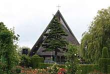
The Pyramid Church
Glasnevin is also a parish in the Fingal South West deanery of the Roman Catholic Archdiocese of Dublin.[10] It is served by the Church of Lady of Dolours.
The church underwent some refurbishment work inside and in its grounds and car park during the first half of 2011. A timber church, which originally stood on Berkeley Road, was moved to a riverside site on Botanic Avenue early in the twentieth century. The altar in this church was from Newgate prison in Dublin. It served as the parish church until it was replaced, in 1972, by a structure resembling a pyramid when viewed from Botanic Avenue. The previous church was known locally as "The Woodener" or "The Wooden" and the new building is still known to older residents as "The new Woodener" or "The Wigwam".
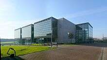
Met Éireann
_(1387399963).jpg)
In 1975 the new headquarters of Met Éireann, the Irish Meteorological Office, opened just off Glasnevin Hill, on the former site of Marlborough House. The Met Éireann building too was built in a somewhat pyramidal shape and is recognised as one of the most significant, smaller commercial buildings, to be erected in Dublin in the 1970s.
Griffith Avenue
Griffith Avenue, which runs through Glasnevin, Drumcondra and Marino. The avenue spans three electoral constituencies. It was named after Arthur Griffith who was the founder and third leader of Sinn Féin and also served as President of Dáil Éireann. Arthur Griffith also was buried in Glasnevin Cemetery.
Amenities and sport
The Gaelic games of Gaelic football, hurling, camogie and Gaelic handball are all organised locally by Na Fianna CLG, while soccer is played by local clubs Tolka Rovers, Glasnevin FC and Glasnaion FC. Basketball is organised by Tolka Rovers. Tennis is played in Charleville Lawn Tennis Club which was founded in 1894 and took its name from the original location at the corner of the Charleville and Cabra Roads. The move to its present location on Whitworth Road took place in 1904. The club has a membership of 400 senior and junior members and the club has won many Dublin Lawn Tennis Council titles. Hockey is also played in Botanic Hockey club on the Old Finglas Road. Glasnevin Boxing Club and Football(soccer) club has a clubhouse on Mobhi road.
Scouting is represented in Glasnevin by the 1st Dublin (L.H.O) Scout Troop located on the corner of Griffith Avenue and Ballygall Road East.[11]
There are several primary schools in Glasnevin, including Lindsay Road National School, Glasnevin National School, Glasnevin Educate Together National school, North Dublin National School Project, Scoil Mobhi, St. Brigids GNS, St. Columbas NS and St.Vincents CBS.
There are several Roman Catholic secondary schools in the area St Vincent's (Christian Brothers) School, Scoil Chaitríona and St Mary's Secondary School.
Billy Whelan, one of the eight Manchester United players who lost their lives in the Munich air disaster of 6 February 1958, was born locally on 1 April 1935. He is buried in Glasnevin Cemetery.[12]
Representation
Glasnevin is part of the Dáil Éireann constituency of Dublin Central and Dublin North-West.
Notable people
- Margaret Buckley, former president of Sinn Féin (originally from Cork, lived on Marguerite Road, Glasnevin)[13]
- Saint Canice, early Christian abbot (studied under Mobhí of Glasnevin)[14]
- Saint Comgall, early Christian abbot and founder of monastery at Bangor[15]
- Ian Gallahar, cyclist and commissaire[16]
- Liam Harrison, musician and songwriter
- Niamh Kavanagh, singer and winner of the Eurovision Song Contest[17]
- Robbie Kelleher, former All-Ireland winning Gaelic footballer[18]
- Anne Kernan (1933–2020), Irish physicist
- Celia Lynch, Fianna Fáil TD and assistant government whip (originally from Galway, lived on Botanic Road)[19]
- Colm Meaney, actor[20]
- Damien McCaul, television presenter and radio DJ[21]
- Saint Mobhi, early Christian missionary and abbot of Glasnevin monastery[15]
- John O'Connell, Fianna Fáil TD and former Minister for Health
- Francis Martin O'Donnell, diplomat
- Patrick Denis O'Donnell, military historian
- Michael O'Hehir, sports commentator and journalist[22]
- James O'Higgins Norman, academic
- John J. O'Kelly, politician, former President of Sinn Féin and government minister
- Michael O'Riordan, founder of the Communist Party of Ireland
- Róisín Owens, biochemist[23]
- Richard Brinsley Sheridan, satirist, playwright, and politician[24]
- Jonathan Swift, author and essayist who lived across the road from the Glasnevin Model School (now Glasnevin Educate Together)
- Thomas Tickell, poet whose Glasnevin property was later developed as the National Botanic Gardens[25]
- David P. Tyndall, businessperson
- Mona Tyndall, doctor and missionary
References
- "Glas Naíon / Glasnevin (civil parish)". logainm.ie. Placenames Database of Ireland. Retrieved 5 May 2020.
- Doyle, Joseph W. (May 2013). Ten Dozen Waters: The Rivers and Streams of County Dublin (7 ed.). Dublin: Rath Eanna Research. p. 19. ISBN 9780956636362.
- "Civil Parish of Glasnevin, Co. Dublin". townlands.ie. Retrieved 5 May 2020.
- "Relation: Glasnevin (5504172)". openstreetmap.org. Retrieved 5 May 2020.
- Mac Giolla Phadraig, Brian (September 1938). "14th century life in a Dublin Monastery". Dublin Historical Record. 3 (1): 69–72.
- Mant, Richard (1840). History of the Church of Ireland.
- Samuel Lewis (1837). Topographical Dictionary of Ireland. Lewis.
- "Glasnevin station" (PDF). Railscot - Irish Railways. Retrieved 14 October 2007.
- Weston St. John Joyce (1920). "XXVI, "Glasnevin, Finglas and the adjacent district"". The Neighbourhood of Dublin (third and enlarged edition) (PDF).
The village of Glasnevin has, of course, been much altered since [18th century resident] Dr. Delay's time, and is now included in the city
- "Glasnevin Parish - Official website". glasnevinparish.ie. Retrieved 5 May 2020.
- "Still Scouting After 100 Years". 1stdublin.com. Archived from the original on 10 August 2013.
- "Find A Grave - Millions of Cemetery Records and Online Memorials". findagrave.com.
- Rafter, Kevin (2005). Sinn Féin, 1905-2005: in the shadow of gunmen. Gill & Macmillan. p. 72. ISBN 9780717139927.
- "St. Canice's Abbey". irishstones.org. Glasnevin Parish. Retrieved 5 May 2020.
- "History of the Parish of Our Lady of Dolours, Glasnevin". glasnevinparish.ie. Retrieved 5 May 2020.
- "Tributes paid on passing of Ian Gallahar". stickybottle.com. 1 March 2012. Retrieved 5 May 2020.
- "Eurovision 1993 Ireland: Niamh Kavanagh - "In Your Eyes"". Eurovisionworld. Retrieved 12 June 2020.
- "The Great Divide: Should Dublin be split in two?". independent.ie. Independent News & Media. 21 January 2018. Retrieved 5 May 2020.
- Nealon, Ted, ed. (1974). Ireland: A Parliamentary Directory, 1973-1974. Institute of Public Administration. p. 28. ISBN 9780902173606.
- "Colm Meaney: "My missus doesn't like Los Angeles. She's French"". irishtimes.com. Irish Times. 6 December 2019. Retrieved 5 May 2020.
- "Me and My Money Damien McCaul". Independent News & Media. 12 June 2007. Retrieved 5 May 2020.
- "O'Hehir the voice of sport for six decades". irishtimes.com. Irish Times. 25 November 1996. Retrieved 5 May 2020.
- "Irish researcher awarded €150,000 from EU". engineersjournal.ie. Engineers Ireland. 10 March 2015. Archived from the original on 29 September 2015.
- "Richard Brinsley Sheridan | Biography & Facts". Encyclopedia Britannica. Retrieved 15 June 2020.
- "National Botanic Gardens, Glasnevin". irelandseye.com. Retrieved 5 May 2020.
Further reading
- The Parish of Glasnevin from F.E. Ball's A History of the County Dublin (1920)
- Account of Glasnevin from D'Alton's History of the County Dublin (1838)
- Glasnevin, Finglas and the Adjacent District from The Neighbourhood of Dublin by Weston St. John Joyce (third and enlarged edition 1920)
- The Tolka, Glasnevin and the Naul Road from North Dublin by Dillon Cosgrove (1909)
External links
| Wikimedia Commons has media related to Glasnevin. |
- Met Éireann
- A History of Glasnevin from Egan's House
- The Botanic Gardens