Glacier morphology
Glacier morphology, or the form a glacier takes, is influenced by temperature, precipitation, topography, and other factors.[1] The goal of glacial morphology is to gain a better understanding of glaciated landscapes, and the way they are shaped.[2] Types of glaciers can range from massive ice sheets, such as the Greenland ice sheet, to small cirque glaciers found perched on mountain tops.[3] Glaciers can be grouped into two main categories:
- Ice flow is constrained by the underlying bedrock topography
- Ice flow is unrestricted by surrounding topography

Unconstrained Glaciers
Ice sheets and Ice Caps
Ice Sheets and Ice Caps cover the largest areas of land in comparison to other glaciers, and their ice is unconstrained by the underlying topography. They are the largest glacial ice formations, and hold the vast majority of the world's fresh water.[4]
Ice Sheets
Ice sheets are the largest form of glacial formation. They are continent sized ice masses that span areas over 50 000 km2[5] They are dome shaped, and similarly to ice caps, exhibit radial flow.[4][5][6] As ice sheets expand over the ocean, they become ice shelves.[6] Ice sheets contain 99% of all the freshwater ice found on Earth, and form as layers of snow fall, accumulate, and slowly start to compact into ice.[5] There are only two ice sheets present on Earth today, and they are the Antarctic Ice Sheet, and the Greenland Ice Sheet. Although only a tenth of modern Earth is covered by ice sheets, the Pleistocene epoch was characterized by ice sheets that covered a third of our land. This was also known as the Last Glacial Maximum[6][7]
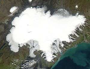
Ice Caps
An ice cap can be defined as a dome shaped mass of ice that exhibits a radial flow.[8] They are often easily confused with ice sheets, but these ice structures are smaller in size. They are smaller than 50 000 km2, and obscure the entirety of the topography they span.[8] They mainly form in polar and sub-polar regions that can be characterized by having particularly high elevation, but flat ground.[4] Ice caps come in a variety of shapes; they can be round or circular, to irregular in shape.[8] Oftentimes, ice caps gradually merge into ice sheets; making them quite hard to track and document.[8] Some examples of ice caps include:
- Jostedalsbreen, Norway
- Devon Ice Cap, Canada
- Barnes Ice Cap, Canada
- Vatnajøkull, Iceland
Ice Domes
An ice dome is a part of an ice cap or ice sheet that is characterized by upstanding ice surface located in the accumulation zone.[8] Ice domes are nearly symmetrical, with a convex or parabolic surface shape.[8] They tend to develop evenly over a land mass that may be either a topographic height or a depression—often reflecting the sub-glacial topography.[8] In ice sheets, domes may reach a thickness that may exceed 3,000 m. However, in ice caps, the thickness of the dome is much smaller; measuring roughly up to several hundred metres in comparison.[8] In glaciated islands, ice domes are usually the highest point of the ice cap.[8] An example of an ice dome is Kupol Vostok Pervyy in Alger Island, Franz Josef Land, Russia.
Ice Streams
Ice streams rapidly channel ice flow out to the sea, ocean, or an ice shelf. For this reason, they are commonly referred to as the "arteries" of an ice sheet.[9][10] Ice from continental sheets is drained into the ocean by a complex network of ice streams, and their activity is greatly affected by oceanic and atmospheric processes.[9] They feature a higher velocity in the centre of the stream, and are bounded by slow moving ice on either side.[11] Periods of greater ice stream flow result in more ice transfer from ice sheets to the ocean; subsequently impacting sea level by raising it.[11] At the margin between glacial ice and water, ice calving takes place as glaciers begin to fracture, and icebergs break off from the large masses of ice.[12][10] Iceberg calving is a major contributor to sea level rise, but the ocean is not the only place that can experience ice calving.[12] Calving can also take place in lakes, fjords, and continental ice cliffs.[12]
Constrained Glaciers
Icefields
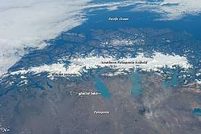
An icefield is an example of glacier structure that covers a relatively large area, and is usually located in areas characterized by mountain terrain.[4] Icefields are quite similar to ice caps; however, their morphology is much more influenced by the underlying mountainous topography.[4]
The rock formations found under the icefields are variable, and rocky mountain peaks known as nunataks tend to jut out from under the surface of icefields.[13][14] Some examples of icefields include:
- Columbia Icefield, Canada
- Juneau Icefield,Canada
- Southern Patagonian Icefield, Chile & Argentina
- Harding Icefield, USA
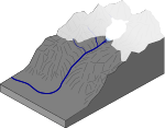
Outlet Glaciers
Outlet glaciers are often found in valleys, and they originate from major ice sheets and ice caps.[4] They move in a singular direction that is determined by the underlying landscape.[13] Outlet glaciers drain inland glaciers through gaps found in the surrounding topography.[4] A higher amount of inland glacial melt ultimately increases the amount of outlet glacier output.[15] Studies predict that outlet glaciers found in Greenland can increase the global sea level considerably following an increase in global temperature, and a subsequently higher drainage output.[16] Some examples of outlet glaciers include[15]:
- Helheim Glacier, Greenland
- Kangerdlugssuaq Glacier, Greenland
- Jakobshavn Glacier, Greenland
- Petermann Glacier, Greenland
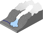
Valley glaciers
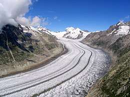

Valley glaciers are outlet glaciers that provide drainage for icefields, icecaps or icesheets.[16] The flow of these glaciers is confined by the walls of the valley they are found in; but they may also form in mountain ranges as gathering snow turns to ice.[4][17] The formation of valley glaciers is restricted by formations such as terminal moraines, which are collections of unconsolidated rock material, or till deposited by the terminus of the glacier. Ice-free exposed bedrock and slopes often surround valley glaciers[18], providing a route for snow and ice to accumulate on the glacier via avalanches. Some examples of valley glaciers include:
- Sermilik Glacier, Canada
- Fláajökull, Iceland
Valley-head glaciers
Valley head glaciers are types of valley glaciers that are only limited to the valley head.[17] An example of this type of valley glacier is Bægisárjökull, found in Iceland.[13]
Fjords
True fjords are formed when valley glaciers retreat and sea water fills the now empty valley. They can be found in mountainous, glaciation affected terrain.[19]Some examples of fjords include:
- Hvalfjörður, Iceland
- Hornsund, Svalbard
- Sognefjord, Norway
- An existing valley glacier of this type is Jakobshavn Glacier in Greenland
Piedmont glaciers
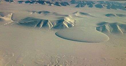
Piedmont glaciers are a subtype of valley glaciers which have flowed out onto lowland plains, where they spread out into a fan-like shape.[13][17]Some examples of piedmont glaciers include:
- Malaspina Glacier, USA
- Endeavor Piedmont Glacier, Antarctica
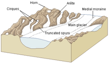
Cirque glaciers
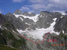
Cirque glaciers are glaciers that appear in bowl shaped valley hollows.[4][13]Snow easily settles in the topographic structure; it is turned to ice as more snow falls and is subsequently compressed.[13]When the glacier melts, a cirque structure is left in its place.[4] Some examples cirque glaciers include:
- Lower Curtis Glacier, USA
- Eel Glacier, USA
Hanging Glacier
A hanging glacier is a form of glacier that appears in a hanging valley, and has the potential to break off from the side of the mountain it is attached to.[13][21] As bits and pieces of hanging glaciers break off and begin to fall, avalanches can be triggered.[21] Examples of hanging glaciers include:
- Eiger Glacier, Switzerland
- Angel Glacier, Canada
References
- "Introduction to Glaciers". National Park Service. Archived from the original on 2006-09-03.
- Treatise on geomorphology. Shroder, John F., 1939-. London: Academic Press. 2013. ISBN 9780080885223. OCLC 831139698.CS1 maint: others (link)
- "National Snow and Ice Data Center (NSIDC)". Choice Reviews Online. 43 (10): 43–5905-43-5905. 2006-06-01. doi:10.5860/choice.43-5905. ISSN 0009-4978.
- "Glacier Types: Ice caps | National Snow and Ice Data Center". nsidc.org. Retrieved 2019-04-05.
- Paul, Frank; Ramanathan, A.L.; Mandal, Arindan (2017-03-06), "Ice Caps", International Encyclopedia of Geography: People, the Earth, Environment and Technology, John Wiley & Sons, Ltd, pp. 1–10, doi:10.1002/9781118786352.wbieg0210, ISBN 9780470659632
- Society, National Geographic (2012-08-16). "ice sheet". National Geographic Society. Retrieved 2019-04-05.
- Clark, P. U.; Dyke, A. S.; Shakun, J. D.; Carlson, A. E.; Clark, J.; Wohlfarth, B.; Mitrovica, J. X.; Hostetler, S. W.; McCabe, A. M. (2009-08-06). "The Last Glacial Maximum". Science. 325 (5941): 710–714. doi:10.1126/science.1172873. ISSN 0036-8075. PMID 19661421.
- Paul, Frank; Ramanathan, A.L.; Mandal, Arindan (2017-03-06), "Ice Caps", International Encyclopedia of Geography: People, the Earth, Environment and Technology, John Wiley & Sons, Ltd, pp. 1–10, doi:10.1002/9781118786352.wbieg0210, ISBN 9780470659632
- Spagnolo, Matteo; Phillips, Emrys; Piotrowski, Jan A.; Rea, Brice R.; Clark, Chris D.; Stokes, Chris R.; Carr, Simon J.; Ely, Jeremy C.; Ribolini, Adriano (2016-02-22). "Ice stream motion facilitated by a shallow-deforming and accreting bed". Nature Communications. 7 (1). doi:10.1038/ncomms10723. ISSN 2041-1723.
- Mcintyre, N. F. (1985). "The Dynamics of Ice-Sheet Outlets". Journal of Glaciology. 31 (108): 99–107. doi:10.1017/S0022143000006328. ISSN 0022-1430.
- Stokes, C. R.; Margold, M.; Clark, C. D.; Tarasov, L. (2016-02-17). "Ice stream activity scaled to ice sheet volume during Laurentide Ice Sheet deglaciation" (PDF). Nature. 530 (7590): 322–326. doi:10.1038/nature16947. ISSN 0028-0836. PMID 26887494.
- Benn, Douglas I.; Åström, Jan A. (2018). "Calving glaciers and ice shelves". Advances in Physics: X. 3 (1): 1513819. doi:10.1080/23746149.2018.1513819. ISSN 2374-6149.
- Björnsson, Helgi (2016-10-05), "Origins and Nature of Glaciers", The Glaciers of Iceland, Atlantis Press, pp. 3–37, doi:10.2991/978-94-6239-207-6_1, ISBN 9789462392069
- Dixon, John C.; Thorn, Colin E.; Darmody, Robert G. (1984). "Chemical Weathering Processes on the Vantage Peak Nunatak, Juneau Icefield, Southern Alaska". Physical Geography. 5 (2): 111–131. doi:10.1080/02723646.1984.10642247. ISSN 0272-3646.
- Howat, I. M.; Joughin, I.; Scambos, T. A. (2007-03-16). "Rapid Changes in Ice Discharge from Greenland Outlet Glaciers". Science. 315 (5818): 1559–1561. doi:10.1126/science.1138478. ISSN 0036-8075. PMID 17289940.
- Nick, Faezeh M.; Vieli, Andreas; Andersen, Morten Langer; Joughin, Ian; Payne, Antony; Edwards, Tamsin L.; Pattyn, Frank; van de Wal, Roderik S. W. (2013-05-08). "Future sea-level rise from Greenland's main outlet glaciers in a warming climate". Nature. 497 (7448): 235–238. doi:10.1038/nature12068. ISSN 0028-0836. PMID 23657350.
- "Valley and Piedmont Glaciers (U.S. National Park Service)". www.nps.gov. Retrieved 2019-04-05.
- "Glacier".
- Dowdeswell, J. A.; Batchelor, C. L.; Hogan, K. A.; Schenke, H.-W. (2016). "Nordvestfjord: a major East Greenland fjord system". Geological Society, London, Memoirs. 46 (1): 43–44. doi:10.1144/m46.40. ISSN 0435-4052.
- Elephant Foot Glacier at NASA Earth Observatory
- Margreth, Stefan; Funk, Martin; Tobler, Daniel; Dalban, Pierre; Meier, Lorenz; Lauper, Juerg (2017). "Analysis of the hazard caused by ice avalanches from the hanging glacier on the Eiger west face". Cold Regions Science and Technology. 144: 63–72. doi:10.1016/j.coldregions.2017.05.012. ISSN 0165-232X.
Sources
- Benn, Douglas I.; Evans, David J.A. (2010). Glaciers & Glaciation (2nd ed.). Abingdon, UK: Hodder. ISBN 978-0-340-905791.
External links
![]()