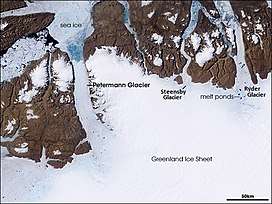
Petermann Glacier
Petermann Glacier (Danish: Petermann Gletsjer) is a large glacier located in North-West Greenland to the east of Nares Strait. It connects the Greenland ice sheet to the Arctic Ocean at 81°10' north latitude, near Hans Island.
| Petermann Glacier | |
|---|---|
| Petermann Gletscher | |
 NASA satellite image. | |
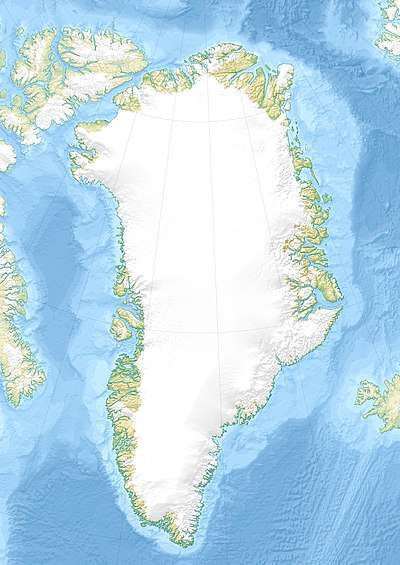 Location within Greenland | |
| Location | Greenland |
| Coordinates | 80°45′N 60°45′W |
| Length | 70 km (43 mi) |
| Width | 15 km (9.3 mi) |
| Thickness | 600 m (2,000 ft) |
| Terminus | Petermann Fjord Hall Basin |
The glacier and its fjord are named after German cartographer August Heinrich Petermann.[1]
Geography
The tidewater glacier consists of a 70 km (43 mi) long and 15 km (9.3 mi) wide floating ice tongue whose thickness changes from about 600 m (2,000 ft) at its grounding line to about 30–80 metres (98–262 ft) at its front.[2] Rough mass balance estimates using these scales suggest that about 80% of its mass is lost as basal meltwater, yet little oceanographic data are available to connect Petermann Glacier to its fjord and adjacent Nares Strait. Even the sill depth and location is largely unknown as modern soundings of the fjord, with its mouth located between Cape Morton and Cape Tyson, are still lacking.[3] Petermann Glacier marks the western limit of Hall Land and the eastern of Daugaard-Jensen Land. The Petermann Peninsula flanks its northern end.[4] The grounding line is relatively stable with on average 470 m variation over the period 1992 to 2011. This indicates that the glacier was dynamically stable.[5]
Satellite Imagery
A series of satellite images from 2002 through 2009 illustrate that the terminus of the glacier has advanced towards the ocean, however, several lateral rifts have developed also. The distance of this rifts or cracks back from the terminus has diminished for this time period also and may serve as a precursor to natural ice calving from Petermann Glacier.[6] A large chunk estimated to be 100 square miles (260 km2) calved off the glacier[7] in August, 2010. The Danish Meteorological Institutes maintains an archive of imagery of Petermann Glacier and adjacent coastal areas of Greenland[8][9] from both European and US satellites and sensors such as Envisat, MODIS, and AVHRR.
Data from Operation IceBridge show a 750 km long subglacial canyon running from the center of the island northward to the fjord of the Petermann Glacier. Dubbed "Greenland Grand Canyon" by media, the bottom is below sea level, and the canyon is likely to have influenced basal water flow from the ice sheet interior to the margin. The canyon predates ice sheet inception and has influenced basal hydrology in Greenland over past glacial cycles.[10]
Ship-Based Science Explorations 2003-2015
The US Coast Guard icebreaker "USCGC Healy" entered the fjord on August 11, 2003 to survey bottom topography, ocean currents, and ocean chemistry as part of a larger program funded by the US National Science Foundation to better understand rates and mechanism by which Arctic sources of fresh water may impact the climate states of the North Atlantic. The program was continued as part of the Canadian International Polar Year projects when the CCGS Henry Larsen entered the fjord in 2007 and 2009.
In 2009, scientists aboard the Greenpeace ship Arctic Sunrise conducted multi-disciplinary measurements at Petermann glacier to document the anticipated detachment of a large area of the glacier to obtain insight into glacier dynamics and to highlight glacier response to ongoing Arctic climate warming ahead of the Copenhagen summit.
During the summer of 2015, the Swedish icebreaker Oden served as the platform for the research carried out in the sea, on the glacier and on land. The purpose of the Swedish-American research expedition was to collect multibeam bathymetry and sub-bottom profile information along the western continental shelf of Greenland in order to characterize the shape of the seafloor and uppermost sediment properties. The main goal was to increase the understanding about potential pathways of relative warmer water influx towards Greenland’s many outlet glaciers. A program involving both seismic data acquisition, multibeam mapping, coring and seismic reflection profiling was conducted in order to study the past behaviour of the Petermann Glacier.
Ice loss
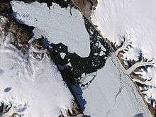
In August 2010, a giant iceberg measuring 260 square kilometres (100 sq mi) broke off from the floating portion of Petermann Glacier reducing its area and volume by about 25% and 10%, respectively. Researchers from the Canadian Ice Service located the calving from NASA satellite images taken on August 5; Patrick Lockerby re-posted cropped NASA images with interpretations on the internet the same day. It was the largest Arctic iceberg to calve since 1962, however, it is unclear whether the event was related to global warming or not.[11] The Select Committee on Energy Independence and Global Warming of the US House of Representatives held hearings on Petermann Glacier and the Greenland icesheet within days of the 2010 break-up.[12]
The National Ice Center named the new iceberg, the Petermann Ice Island (2010)[13] to differentiate it from a similar calving event two years earlier which produced Petermann Ice Island (2008). That island was tracked by the Canadian Ice Service for over a year as it travelled out into Nares Strait and south through Baffin Bay before losing contact with the remnants in Frobisher Bay in July 2009.[14]
On July 15/16 2012, a 130-square-kilometre (50 sq mi) piece (about twice the area of Manhattan), calved from the northern tip of the glacier. A long crack at the site had been observed by NASA satellites for several years prior to the split.[15]
Recent developments
The Peterman glacier has grown several kilometers in length since 2012. The development can be seen on NASA Satellite Imagery.
.jpg) Ice calving from Petermann Glacier in 2010. |
 Astronauts on the International Space Station used a digital camera to capture this view of Petermann Ice Island A, fragment 2, off of the north-east coast of Newfoundland. |
 July 16, 2012 calving event. |
A new crack was seen in 2017.[16]
References
- Sides, Hampton (2014). In The Kingdom of Ice: The Grand and Terrible Polar Voyage of the USS Jeannette. Doubleday. p. 406. ISBN 978-0385535373.
- Rignot, E. and K. Steffen, 2008: Channelized bottom melting and stability of floating ice shelves, Geophys. Res. Let., 35, L02,503.
- Johnson, H.L., A. Muenchow, K.K. Falkner, and H. Melling, 2010: Ocean Circulation and properties in Petermann Fjord, Greenland, Journal of Geophysical Research, doi:10.1029/2010JC006519.
- "Hall Land". Mapcarta. Retrieved 8 April 2016.
- Anna E. Hogg, Andrew Shepherd, Noel Gourmelen, Marcus Engdal (2016). "Grounding line migration from 1992 to 2011 on Petermann Glacier, North-West Greenland" (PDF). Journal of Glaciology. 62 (236): 1104–1114. doi:10.1017/jog.2016.83.CS1 maint: multiple names: authors list (link)
- "What links the retreat of Jakobshavn Isbrae, Wilkins Ice Shelf and the Petermann Glacier?". RealClimate. Retrieved 2012-07-18.
- McNally, Jess (August 6, 2010). "Enormous Ice Block Breaks Off Greenland Glacier". Wired.
- "COI | Centre for Ocean and Ice | Danmarks Meteorologiske Institut". Ocean.dmi.dk. 2009-06-21. Retrieved 2012-07-18.
- Pictures before and after Archived 2010-12-30 at the Wayback Machine
- "Greenland's Mega Canyon (narrated video)". NASA. 2013-08-29. Archived from the original on 2016-08-04. Retrieved 2013-08-30.
- Huge ice sheet breaks from Greenland glacier
- US House of Representatives Aug.-10, 2010 Briefing on "The Greenland ice sheet: Global Warming's impact in Arctic regions"
- The National Ice Center Press Release
- Canadian Ice Service information page on the Petermann Ice Island (2008) Archived 2011-06-11 at the Wayback Machine
- The Associated Press. "Iceberg twice the size of Manhattan breaks off Greenland glacier - Technology & Science - CBC News". Cbc.ca. Retrieved 2012-07-18.
- Chris Mooney (April 15, 2017). "NASA just snapped the first photos of a mysterious crack in one of Greenland's largest glaciers". Retrieved April 16, 2017.
External links
| Wikimedia Commons has media related to Petermann Glacier. |
- MODIS Studies of Greenland at Byrd Polar Research Center
- Satellite Imagery of Greenland from Danish Meteorological Institute
- Satellite images of the Petermann glacier 2010 and 2009
- Video Interview 2009 on Petermann Glacier
- "Top of the World" Petermann Glacier 60 Minutes July 31, 2016