Germany–Netherlands border
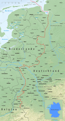
The Germany–Netherlands border consists of a land border that is 570 km (350 mi) long (including rivers but excluding the maritime border in the Dollart bay and outside it) and a maritime border running from the bay through the Frisian Islands into the North Sea.


Land border
The border is located in the northwestern part of Germany and the east of the Netherlands. The border runs as a fairly irregular line from the shore of the Dollart bay which is part of the Ems river estuary in the north to the Belgium-Germany-Netherlands tripoint at Vaalserberg. The length of the border is around 570 km (350 mi) in length, although the straight distance between the two border end points is 288 km (179 mi).
The border runs along portions of rivers, including for 8 km (5.0 mi) along the large Rhine river. It also runs for about 100 km (62 mi) along the Meuse valley, although most of the time a few km to the east of the Meuse river rather than along it, before leaving the valley at the last portion of border to the border tripoint located at Vaalserberg about 3 km (1.9 mi) west of Aachen.
The German states which share the international border are (from north to south) Lower Saxony and North Rhine-Westphalia while on the Dutch side, the provinces are Groningen, Drente, Overijssel, Gelderland and Limburg.
Border crossings
There are at least 60 official road crossings and six railway crossings of the border. Both countries are part of the Schengen Area and the European Union, so there are minimal or non-existent border controls.
Motorways crossing the border:
| Dutch name | German name | European route |
| A7 | A280 | E22 |
| A37 | B402 | E233 |
| A1 | A30 | E30 |
| A12 | A3 | E35 |
| A77 | A57 | E31 |
| A67 | A40 | E34 |
| A74 | A61 | - |
| N280 | A52 | - |
| A76 | A4 | E314 |
Railways crossing the border:
Border Treaties
The modern border today is the result of centuries of border negotiations and agreements between the states and other political entities in the region, such as the Kingdom of Prussia, Kingdom of Hannover and the United Provinces of the Netherlands, of which Germany and the Netherlands ultimately became the modern day successor states. Many of the border agreements and treaties drawn up between these states were adopted by subsequent treaties and remain in force today.[1][2]
Treaties between Prussia and the Netherlands
Treaties with Prussia largely delimited and provided for the demarcation of the southern portion of Germany–Netherlands border from Losser south to Vaals. Among the agreements and treaties were:
- Treaty between Great Britain, Austria, Prussia, and Russia, and Netherlands, signed in Vienna on 31 May 1815. Signed as part of the Congress of Vienna.
- Boundary Treaties between the Kingdom of Prussia and the Kingdom of the Netherlands signed in Aachen on 26 June 1816 and Cleves on 7 October 1816.
- General Record drawn up between the Kingdom of the Netherlands and the Kingdom of Prussia concerning the frontier lines, signed at Emmerich, 23 September 1818.
- Treaty between the Kingdom of the Netherlands and the Kingdom of Prussia concerning the frontier line between the two States at several points between the province of Limburg and the district of Aachen signed in Aachen, 11 December 1868.
- Instruments between the Kingdom of the Netherlands and the Kingdom of Prussia concerning abolition of the right of pasturage in fallow land (jus compascui) signed in Münster, 30 October 1823.
- Further Agreement between the Kingdom of the Netherlands and the Kingdom of Prussia modifying the partial frontier along Gelderland fixed by the Agreement of 30 October 1823 and abolishing the right of pasturage in fallow land, signed on 11 April 1827.
- Final Protocol,with annexes, between the Kingdom of the Netherlands and the Kingdom of Prussia fixing the frontier line between Netterden and Vrasselt; Emmerich, signed on 23 June 1843.
- Agreement between the Kindgom of the Netherlands and the Kingdom of Prussia defining the frontier line between the Netherlands commune of Dinxperlo and the Prussian commune of SUderwick; signed in Dinxperlo on 12 August 1872.
- Agreement between the Kingdom of the Netherlands and the Kingdom of Prussia concerning the frontier line between the two States at the Netherlands commune of Winterswijk and the Prussian commune of Barlo, signed in Winterswijk on 22 August 1879.
- Agreement between the Kingdom of the Netherlands and the Kingdom of Prussia defining the frontier between Eibergen and Ammeloe, signed in Eibergen on 12 May 1880.
- Agreement between the Kingdom of the Netherlands and the Kingdom of Prussia adjusting the frontier between Eibergen and Ammeloe, signed in Bentheim on 16 August 1883.
- Agreement between the Kingdom of the Netherlands and the Kingdom of Prussia fixing the State frontier at and in the section of the Buiten Aa lying between boundary stones No. 202 and 202a, which has been abandoned and filled in as a result of the construction in Netherlands territory of the Nieuwe Statenzijl (New State Dike-lock) signed at Aurich/Groningen on 1 and 31 August 1882; with Additional Declaration at Aurich/Groningen on 27 April and 29 May 1883.
Treaties between Hannover and the Netherlands
Treaties with Hannover largely delimited and provided for the demarcation of the northern portion of Germany–Netherlands border north of Losser. Among the agreements and treaties were:
- Frontier Treaty between the Kingdom of Hanover and the Kingdom of the Netherlands relating to the course of the frontier signed in Meppen on 2 July 1824.
- Instrument between the Kingdom of the Netherlands and the Kingdom of Hanover defining the frontiers of 12 September 1825.
- Exchange of declarations between the Netherlands and Hanoverian Governments fixing the frontier line in the Dollard, signed in The Hague and Hanover on 14 and 19 March 1863.
Paris Protocol 1949
The Paris Protocol of March 22, 1949 following the Second World War, the Commission made 19 provisional changes in the frontier allowing the Netherlands to annex pieces of German territory totaling 26 square miles and 487 acres.[2] The annexation was based on the Report by the Demarcation Commission of the Netherlands-German Frontier, signed at The Hague on December 10, 1949. The Netherlands annexed pieces of German territory as part of Second World War reparations.
For more details on the annexation, see Dutch annexation of German territory after the Second World War.
Treaties with Germany
Following the Second World War, the following treaties were signed between Germany and the Netherlands:
- Treaty Between The Kingdom Of The Netherlands And The Federal Republic Of Germany Concerning The Course Of The Common Frontier, The Boundary Waters, Real Property Situated Near The Frontier, Traffic Crossing The Frontier On Land And Via Inland Waters, And Other Frontier Questions, known in short as the "Frontier Treaty", signed at The Hague on 8 April 1960.[3] This treaty, which came into effect on 10 June 1963, provided for the return of most of the German territories annexed by the Netherlands under the Paris Protocol of 1949, thus establishing the land boundary of the two countries that exists to this day.
Disputes
The maritime border is disputed in a part of the Ems estuary outside the Dollart bay, where Germany has the view that the state border runs on the left bank of the Ems, while the Netherlands regards the Thalweg as its border. This is based on interpretations of old treaties. Germany relies on a bill of enfeoffment from 1464, when German Emperor Frederick III raised Ulrich I, the son of a local chieftain to the status of Imperial Count, in which the County of East Frisia Is described as "von der Westeremse osterwards" (thus including the Ems). According to the Netherlands, this has lapsed in the French period - after the incorporation in France of both areas of West Frisia (now part of the Dutch provinces of Groningen and Friesland) and East Frisia (now part of the German state of Lower Saxony). Thus according to international law, the boundary should be at the center of the navigation channel.
See also
References
- List of treaties provided in the footnotes of "Frontier Treaty between Germany and the Netherlands 1960" (PDF). UN Treaty Series. United Nations. 8 April 1960. Retrieved 25 April 2020.
- "International Boundary Study: Germany-Netherlands Boundary" (PDF). International Boundary Study. United States Department of State. 6 April 1964. Archived from the original (PDF) on 16 September 2006. Retrieved 25 April 2020.
- "Frontier Treaty between Germany and the Netherlands 1960" (PDF). UN Treaty Series. United Nations. 8 April 1960. Retrieved 25 April 2020.
| Wikimedia Commons has media related to Germany-Netherlands border. |