Dollart
The Dollart (German name) or Dollard (Dutch name) is a bay in the Wadden Sea between the northern Netherlands and Germany, on the west side of the estuary of the Ems river. Most of it dries at low tide. Many water birds feed there.

Gaining from and losing to the sea

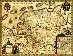
The Dollart Bay was created by a catastrophic storm surge in 1277,[1] covering the district of Reiderland and large parts of the Oldambt district. The flood inundated 43 parishes, and is estimated to have caused 80,000 deaths.[2] Another storm surge in 1509 further extended the Dollart, flooding 30 more villages,[3] and by 1520 the Dollart had its largest extension. Between the 16th and the 20th centuries, two thirds of the drowned area was reclaimed again.
Nowadays the unembanked forelands have been declared world natural heritage, as they are a paradise for all kinds of birds and other aquatic species.[4]
Border dispute

The Netherlands and Germany do not agree on the exact course of the border through the bay,[5] yet they have agreed to disagree by signing a treaty in 1960, laying out mutual responsibilities.[6] Around 2011, the territorial dispute gained relevance with plans for the Borkum Riffgat offshore wind farm.[7] The question about use and administration of the territorial waters between 3 and 12 nautical miles (where the wind farm is located) was settled with another treaty in 2014 by defining a "line", while the border dispute itself remained unresolved.[8]
Literature
- K. Essink (ed.), Stormvloed 1509. Geschiedenis van de Dollard, Groningen: Stichting Verdronken Geschiedenis 2013 (online)
- O.S. Knottnerus, 'Reclamations and submerged lands in the Ems River Estuary (900-1500)'. In: Erik Thoen et al. (eds.), Landscapes or seascapes?. The history of the coastal environment in the North Sea area reconsidered, Turnhout 2013, S. 241-266.
- Gozewinus Acker Stratingh und G.A. Venema, De Dollard of geschied,- aardrijks- en natuurkundige beschrijving van dezen boezem der Eems, Groningen 1855, repr. 1979
- Frank Westerman: De graanrepubliek. Atlas, Amsterdam/Antwerpen 1999, erweitert 2009. [Deutsche Ausgabe Das Getreideparadies. Ch. Links, Berlin 2009, ISBN 978-3-86153-550-8.]
References
- Goffart, Walter (2003). Historical Atlases: The First Three Hundred Years, 1570-1870. University of Chicago Press. p. 126. ISBN 9780226300719. Retrieved 2018-09-16.
- Suess, Edward (1906). The Face of the Earth. Clarendon Press. p. 417. Retrieved 2018-09-16.
dollart ems flood 1277.
- ""Stormvloed 1509" - een Nederlands – Duits cultuurhistorisch project" ["Stormvloed 1509" - a Dutch-German cultural-historical project]. Stichting Verdronken Geschiedenis (in Dutch). 2009. Retrieved 2018-09-16.
- "Wadden Sea". World Heritage Center. UNESCO. Retrieved 2018-09-16.
- "Layer Nordsee - Ems-Dollart-Vertrag" (in German). State of Lower Saxony. Archived from the original on 4 January 2018. Retrieved 3 January 2018.
- "Verdrag tussen het Koninkrijk der Nederlanden en de Bondsrepubliek Duitsland tot [...] van de samenwerking in de Eemsmonding (Eems-Dollardverdrag), 's-Gravenhage, 08-04-1960" (in Dutch). Government of the Netherlands. 1 July 1978. Retrieved 3 January 2018.
- "Nederland en Duitsland bespreken zeegrens" (in Dutch). Spits. 14 January 2011. Archived from the original on 14 January 2011.
- "Verdrag tussen het Koninkrijk der Nederlanden en de Bondsrepubliek Duitsland betreffende het gebruik en beheer van de territoriale zee van 3 tot 12 zeemijlen; (met gemeenschappelijke verklaring en briefwisseling) Op de Eems, 24 oktober 2014" (in Dutch). Government of the Netherlands. 24 October 2014. Retrieved 3 January 2018.
External links

| Authority control |
|---|
Bays and former bays on the East Frisian Peninsula | ||
|---|---|---|
|  | |