Geography of Antigua and Barbuda
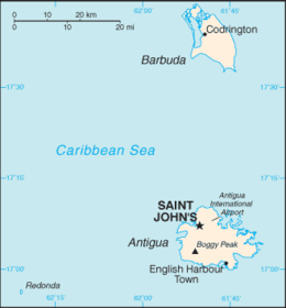
Antigua and Barbuda lie in the eastern arc of the Leeward Islands of the Lesser Antilles, separating the Atlantic Ocean from the Caribbean Sea. Antigua is 650 km (400 mi) southeast of Puerto Rico; Barbuda lies 48 km (30 mi) due north of Antigua, and the uninhabited island of Redonda is 56 km (35 mi) southwest of Antigua.
 | |
| Region | Caribbean |
|---|---|
| Coordinates | 17°03′N 61°48′W |
| Area | Ranked 181st |
| • Total | 442.6 km2 (170.9 sq mi) |
| • Land | 95.33% |
| • Water | 4.67% |
| Coastline | 153 km (95 mi) |
| Borders | No land borders |
| Highest point | Boggy Peak 402 meters (1,319 ft) |
| Lowest point | Atlantic Ocean 0 metres (0 ft) |
| Longest river | None |
| Largest lake | Potsworks Reservoir 2.430 ha (6.00 acres) |
| Terrain | low-lying limestone and coral islands, with some higher volcanic areas |
| Natural Resources | marine resources, cotton |
| Natural Hazards | hurricanes and tropical storms (July to October); periodic droughts |
| Environmental Issues | water management, deforestation |
| Exclusive economic zone | 110,089 km2 (42,506 sq mi) |

The largest island of Antigua, is 21 km (about a dozen miles) across and 281 km² (about a hundred square miles) in area. Barbuda covers 161 km2 (62 sq mi) while Redonda encompasses a 1.6 km2 (0.62 sq mi). The capital of Antigua and Barbuda is St. John's, located at St. John's Harbour on the northwest coast of Antigua. The principal city of Barbuda is Codrington, located on Codrington Lagoon.
Geology
Antigua and Barbuda both are generally low-lying islands whose terrain has been influenced more by limestone formations than volcanic activity. The highest point on Antigua is Boggy Peak, the remnant of a volcanic crater rising 402 meters (1,319 ft). This mountain is located amid a bulge of hills of volcanic origin in the southwestern part of the island. Lake Estate is the third tallest recorded point on Antigua.
The limestone formations in the northeast and northwest are separated from the southwestern volcanic area by a central plain of clay formations. The map of northeastern Antigua features several small and tiny islands, some inhabited. Barbuda's highest elevation is 42 meters (146 ft), part of the highland plateau east of Codrington. The shorelines of both islands are greatly indented with beaches, lagoons, and natural harbors. The islands are rimmed by reefs and shoals. There are few streams as rainfall is slight. Both islands lack adequate amounts of fresh groundwater. Tiny Redonda rises to 246 metres (807 ft) and has very little level ground, while Barbuda is very flat with few if any hills.
Oceanography
There are many coral reefs in the vicinity of Antigua and Barbuda. The island of Guadeloupe lies to the southern, on the far side of the Guadeloupe Passage from Antigua. Due to the spread out islands it has an Exclusive Economic Zone of 110,089 km2 (42,506 sq mi).
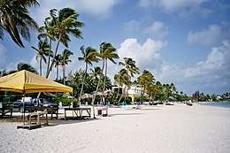
Antigua and Barbuda is famous for its beaches, estimated at 365, particularly those on Antigua itself. The most noteworthy feature of Barbuda’s coastline is the natural lagoon on the western side of the island.
Islands
- Antigua 17°5′0″N 61°48′0″W
- Prickly Pear Island 17°10′33″N 61°47′53″W
- Great Bird Island 17°8′46″N 61°43′31″W
- Galley Island Major 17°08′35.5″N 61°43′37.5″W
- Galley Island Minor
- Jenny Island
- Exchange Island 17°08′11″N 61°43′23″W
- Rabbit Island 17°8′10″N 61°43′52″W
- Lobster Island 17°8′1″N 61°43′47″W
- Long Island 17°9′19″N 61°45′14″W
- Maiden Island 17°8′44″N 61°45′48″W
- Rat Island 17°7′44″N 61°46′11″W
- Little Bird Island 17°09′27″N 61°44′17″W
- Hells Gate Island 17°8′26″N 61°43′18″W
- Monocle Point Island
- Red Head Island 17°8′16″N 61°43′41″W
- Guiana Island 17°7′26″N 61°43′57″W
- Crump Island 17°6′32″N 61°43′8″W
- Nanny Island (Henry Island) 17°04′05″N 61°41′26″W
- Laviscounts Island 17°5′57″N 61°43′24″W
- Bird Island 17°4′45″N 61°40′20″W
- Round Island
- Hawes Island 17°6′46″N 61°43′40″W
- Little Island
- Green Island 17°4′11″N 61°39′58″W
- Pelican Island 17°06′21″N 61°42′17″W
- York Island 17°3′11″N 61°40′9″W
- Codrington Island 17°6′9″N 61°42′21″W
- Blake Island 17°0′52″N 61°46′58″W
- Cinnamon Island 17°7′21″N 61°47′9″W
- Hawksbill Rock 17°6′43″N 61°54′8″W
- Johnson Island 17°01′31″N 61°53′28″W
- Maiden Island 17°5′44″N 61°53′14″W
- Moor Rock 17°09′49″N 61°45′27.0″W
- Mouse Island 17°07′42.0″N 61°46′13″W
- Neck of Land 17°03′40″N 61°40′29″W
- Sandy Island 17°8′4″N 61°55′36″W
- Smith Island 17°2′27″N 61°40′48″W
- The Sisters 17°9′39″N 61°52′6″W
- Vernon's Island 17°6′51″N 61°46′8″W
- Wicked Will Island 17°02′53.5″N 61°40′19.5″W
- Barbuda 17°37′0″N 61°48′0″W
- Goat Island 17°42′20″N 61°50′49″W
- Kid Island 17°41′47″N 61°48′52″W
- Man of War Island 17°40′5″N 61°51′5″W
- Rabbit Island 17°42′23″N 61°49′36″W
- Redonda 16°56′20″N 62°20′30″W
Climate
The islands' climate is classified as Tropical Maritime and is moderated by fairly constant northeast tradewinds, with velocities ranging between 30 and 48 km/h (19 and 30 mph). There is little precipitation because of the islands' low elevations. The pleasant climate fosters tourism.
Rainfall averages 990 mm (39 in) per year, with the amount varying widely from season to season. In general the wettest period is between September and November. The islands generally experience low humidity and recurrent droughts.
Hurricanes strike on an average of once a year between July and October. Temperatures average 27 °C (80.6 °F), with a range from 23 °C (73.4 °F) in the winter to 30 °C (86 °F) in the summer and autumn. The coolest period is between December and February. Its low humidity makes it one of the most temperate climates in the world.
.jpg)
Vegetation

The sandy soil on much of the islands has only scrub vegetation. Some parts of Antigua are more fertile–most notably the central plain–due to the volcanic ash in the soil. These areas support some tropical vegetation and agricultural uses. The planting of acacia, mahogany, and red and white cedar on Antigua has led to as much as 11% of the land becoming forested, helping to conserve the soil and water.
Statistics
- Location
- Antigua and Barbuda are Caribbean islands between the Caribbean Sea and the North Atlantic Ocean, east-southeast of Puerto Rico.
- Geographic coordinates
- 17°03′N 61°48′W
- Area
- Total: 442.6 km2 (170.9 sq mi) (Antigua 280 km2 (110 sq mi); Barbuda 161 km2 (62 sq mi))
- country comparison to the world: 205
- Land: 442.6 km2 (170.9 sq mi)
- Note: Includes Redonda, 1.6 km2 (0.62 sq mi):
- Maritime claims
-
- Territorial sea: 12 nautical miles (22.2 km; 13.8 mi)
- Contiguous zone: 24 nautical miles (44.4 km; 27.6 mi)
- Exclusive economic zone: 110,089 km2 (42,506 sq mi) and 200 nautical miles (370.4 km; 230.2 mi)
- Continental shelf: 200 nautical miles (370.4 km; 230.2 mi) or to the edge of the continental margin
- Terrain
- Mostly low-lying limestone and coral islands, with some higher volcanic areas
- Land use
- Arable land: 20.5%
- Permanent crops: 2.3%
- Permanent pasture: 9.1%
- Forest: 22.3%
- Other: 57.2% (2011)
- Irrigated land
- 1.3 km2 (0.50 sq mi) (2012)
- Total renewable water resources
- 0.05 km3 (0.012 cu mi) (2011)
- Freshwater withdrawal (domestic/industrial/agricultural)
- Total: 0.01 km3 (0.0024 cu mi)/yr (63%/21%/15%)
- Per capita: 97.67 m3 (128 cu yd)/yr (2005)
- Environment - current issues
- Water management, a major concern because of limited natural fresh water resources, is further hampered by the clearing of trees to increase crop production, causing rainfall to run off quickly
- Environment
- international agreements
- Party to: Biodiversity, Climate Change, Climate Change-Kyoto Protocol, Desertification, Endangered Species, Environmental Modification, Hazardous Wastes, Law of the Sea, Marine Dumping, Nuclear Test Ban, Ozone Layer Protection, Ship Pollution, Wetlands, Whaling
- Geography - note
- Antigua has a deeply indented shoreline with many natural harbors and beaches. Antigua's southernmost point is Cape Shirley.
- Barbuda has a large western harbor.
Extreme points
Antigua
- Northernmost point – Boon Point
- Easternmost point - Man of War Point, Green Island
- Easternmost point (mainland only) - Neck of Land
- Southernmost point - Nanton Point
- Southernmost point (including Redonda) - headland on southern coast of Redonda (also the southernmost point in Antigua and Barbuda)
- Westernmost point - Five Islands
- Westernmost point (including Redonda) - headland on Western coast of Redonda (also the westernnmost point in Antigua and Barbuda)
- Westernmost point (mainland only) - Pearns Point
- Lowest point: Caribbean Sea: 0 m
- Highest point: Boggy Peak: 402 m (1,319 ft)
Barbuda
- Northernmost point – Goat Point (also the northernmost point in Antigua and Barbuda)
- Easternmost point - unnamed headland on eastern coast (also the easternnmost point in Antigua and Barbuda)
- Southernmost point - Coco Point
- Westernmost point - Cedar Tree Point
References

| Sovereign states |  | |
|---|---|---|
Dependencies and other territories |
| |