Geography of Guatemala
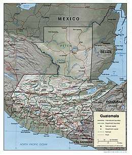
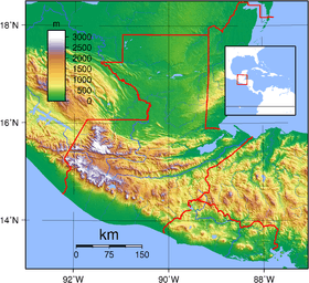
Guatemala is mountainous, except for the south coastal area and the vast northern lowlands of Petén department. The country is located in Central America, bordering the Caribbean Sea, between Honduras and Belize and bordering the North Pacific Ocean, between El Salvador and Mexico. Two mountain chains enter Guatemala from west to east, dividing the country into three major regions: the highlands, where the mountains are located; the Pacific coast, south of the mountains; and the limestone plateau of the Petén region, north of the mountains. These areas vary in climate, elevation, and landscape, providing dramatic contrasts between hot and humid tropical lowlands and highland peaks and valleys.
 | |
| Continent | North America |
|---|---|
| Region | Central America |
| Coordinates | 15°30′N 90°15′W |
| Area | Ranked 105th |
| • Total | 108,889 km2 (42,042 sq mi) |
| • Land | 98.41% |
| • Water | 1.59% |
| Coastline | 400 km (250 mi) |
| Borders | total: 1,667 km (1,036 mi) |
| Highest point | Tajumulco Volcano 4,220 m or 13,845 ft} |
| Lowest point | Pacific Ocean 0 m |
| Longest river | Motagua River 486 km (302 mi) |
| Largest lake | Lake Izabal 589.6 km2 (227.6 sq mi) |
| Exclusive economic zone | 114,170 km2 (44,080 sq mi) |

Regions
The southern edge of the western highlands is marked by the Sierra Madre, which stretches from the Mexican border south and east, and continues at lower elevations toward El Salvador. The mountain chain is characterized by steep volcanic cones, including Tajumulco Volcano 4,220 m or 13,845 ft, the highest point in the country and Central America. All of Guatemala's 37 volcanoes (3 of them active: Pacaya, Santiaguito and Fuego), are in this mountain chain, and are abundant in the highlands.
The northern chain of mountains begins near the Mexican border with the Cuchumatanes range, then stretches east through the Chuacús and Chamá sierras, down to the Santa Cruz and Minas sierras, near the Caribbean Sea. The northern and southern mountains are separated by the Motagua valley, where the Motagua river and its tributaries drains from the highlands into the Caribbean being navigable in its lower end, where it forms the boundary with Honduras.
The rivers are short and shallow in the Pacific vertient, larger and deeper, such as the Polochic which drains in Lake Izabal, Río Dulce, Motagua and Sarstún that forms the boundary with Belize in the Caribbean and the Gulf of Mexico vertient (Usumacinta, which forms the boundary between Chiapas, Mexico and Petén and its tributaries such as La Pasión and San Pedro.
Most of the major cities are located in the Highlands. Major cities are the capital Guatemala City, elevation 1,500 m (Central Highlands), Antigua Guatemala, elevation 1,530 m (Central Highlands), Quetzaltenango elevation 2,350 m (Western Highlands) and Puerto Barrios on the Caribbean coast. The largest lake Lago de Izabal (589.6 km²), is close to the Caribbean coast. Volcán Tajumulco, 4,220 m, the highest point in Central America, is located in the western department of San Marcos.
The last major earthquake was on February 4, 1976, killing more than 23,000 in the Central Highlands.
Climate
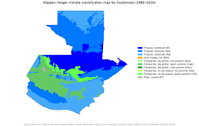
Climate is hot and humid in the Pacific and Petén Lowlands. It is more temperate in the highlands, to freezing cold at the high of the Cuchumatanes range, and hot/drier in the easternmost departments.
Guatemala's location on the Caribbean Sea and Pacific Ocean makes it a target for hurricanes, including Hurricane Mitch in 1998 and Hurricane Stan in October 2005, which killed more than 1,500 people. The damage was not wind related, but caused by flooding and landslides.
A report by the Guatemalan System of Climate Change Sciences in 2019 indicated that rainy season is starting later as a result of climate change, putting subsistence farmers and indigenous people in poor communities at risk of food shortages resulting from poor harvests.[1]
Guatemala has joined the V20, a group of 48 developing economies working together with development banks towards climate resilience and 100% renewable energy.[2]
Geographic data
- Geographic coordinates
- 15°30′N 90°15′W
- Map references
- Central America and the Caribbean
- Area
-
- Total: 108,889 km²
- Land: 107,159 km²
- Land boundaries
-
- Total: 1,667 km
- Border countries: Belize 266 km, El Salvador 199 km, Honduras 244 km, Mexico 958 km
- Coastline
- 400 km
- Maritime claims
-
- Territorial sea: 12 nmi (22 km)
- Exclusive economic zone: 114,170 km2 (44,080 sq mi) and 200 nmi (370 km)
- Continental shelf: 200 m depth or to the depth of exploitation
- Extreme points
- Northernmost point – Border with Mexico
- Southernmost point – Border with El Salvador, near Garita Chapina, Jutiapa Department
- Westernmost point – Border with Mexico on Pacific coast, San Marcos Department
- Easternmost point – Border with Honduras, Izabal Department
- Lowest point – Pacific Ocean and Caribbean Sea: 0 m
- Highest point – Volcán Tajumulco: 4,220 m
- Natural resources
- Petroleum, nickel, rare woods, fish, chicle, hydropower
- Land use
-
- Arable land: 14.32%
- Permanent crops: 8.82%
- Other: 76.87% (2012 est.)
- Irrigated land
- 3,121 km² (2003)
- Total renewable water resources
- 111.3 km3 (2011)
- Freshwater withdrawal (domestic/industrial/agricultural)
-
- total: 3.46 km3/yr (15%/31%/54%)
- per capita: 259.1 m3/yr (2006)
- Natural hazards
- Several active volcanoes, occasional violent earthquakes; Caribbean coast subject to hurricanes and other tropical storms, causing flooding, mudflows and landslides
- Environment—current issues
- Deforestation; soil erosion; water pollution
- Environment—international agreements
-
- Party to: Antarctic Treaty, Biodiversity, Climate Change, Climate Change-Kyoto Protocol, Desertification, Endangered Species, Environmental Modification, Hazardous Wastes, Law of the Sea, Marine Dumping, Nuclear Test Ban, Ozone Layer Protection, Ship Pollution (MARPOL 73/78), Wetlands
- Signed, but not ratified: Antarctic-Environmental Protocol
- Geography—note
- No natural harbors on west coast
See also
References
- Moloney, Anastasia (2019-05-04). "The poorest in Guatemala bear brunt of climate change, research says". Reuters. Retrieved 2019-05-04.
- Rowling, Megan (2019-04-12). "Shunned by investors, poorer nations seek to climate-proof growth". Reuters. Retrieved 2019-05-04.
| History |  | ||||
|---|---|---|---|---|---|
| Geography |
| ||||
| Politics | |||||
| Economy | |||||
| Society |
| ||||
| |||||
| Sovereign states | 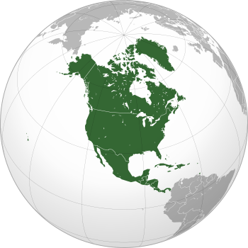 | |
|---|---|---|
Dependencies and other territories |
| |