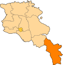
Meghri
Meghri (Armenian: Մեղրի) is a town and the center of the urban community of Meghri, in Syunik Province at the south of Armenia, near the border with Iran. As of the 2011 census, the population of the town was 4,580. According to the 2016 official estimate, Meghri's population is around 3,500.
Meghri Մեղրի | |
|---|---|
 Meghri | |
 Meghri | |
| Coordinates: 38°54′12″N 46°14′45″E | |
| Country | |
| Province | Syunik |
| Municipality | Meghri |
| Founded as Karchavan by Smbat I Bagratuni | 906 |
| Area | |
| • Total | 3 km2 (1 sq mi) |
| Elevation | 610 m (2,000 ft) |
| Population (2011 census) | |
| • Total | 4,580 |
| • Density | 1,500/km2 (4,000/sq mi) |
| Time zone | GMT +4 |
| Website | Official website |
| Population:[1] Elevation:[2] | |
Meghri is located 376 km south of the capital Yerevan and 73 km south of the provincial capital Kapan. A nearby Russian military base houses around 2,000 soldiers, who along with Armenian soldiers guard the border with Iran.
As a result of the community mergers in 2016, the municipality of Meghri was enlarged to include the surrounding villages of Agarak, Alvank, Aygedzor, Gudemnis, Karchevan, Kuris, Lehvaz, Lichk, Nrnadzor, Shvanidzor, Tashtun, Tkhkut, Vahravar, and Vardanidzor.[3]
Etymology
Meghri was founded as "Karchavan" in 906 by king Smbat I of Armenia, during the period of the Bagratid Kingdom of Armenia. Later, it was known as Meghri, meaning "honey town" in the Armenian language.
History
Ancient history and Middle Ages
The area of present-day Meghri has been settled since the Bronze Age. Many archaeological sites are found in the vicinity of the town dating back to the 7th and 6th centuries BC, during the period of Urartu kingdom. Historically, it has been part of Arevik canton of ancient Syunik province of the Kingdom of Armenia.
.JPG)
With the establishment of Tatev monastery in the 8th century, the region of modern-day Meghri witnessed a rapid social and economic development. In 906, the settlement of Karchavan was founded by king Smbat I Bagratuni of the Bagratuni dynasty. In 987, the town (known as Meghri) was included within the newly-founded Armenian Kingdom of Syunik. In 1105, the region of Meghri was occupied by the Seljuks. The town was completely destroyed in 1126 and 1157 by the invading Seljuk forces.
Between the 12th and 15th centuries, Syunik, along with the rest of the historic territories of Armenia, suffered from the Seljuk, Mongol, Aq Qoyunlu and Kara Koyunlu invasions, respectively.
Foreign rule
At the beginning of the 16th century, Meghri became part of the Erivan Beglarbegi within the Safavid Persia. At the beginning of the 18th century, the region was involved in the liberation campaign of the Armenians of Syunik led by David Bek, against Safavid Persia and the invading Ottoman Turks. David Bek started his battles in 1722 with the help of thousands of local Armenian patriots who liberated Syunik.[4]
.jpg)
In 1813, Meghri became part of the Russian Empire as a result of the Russo-Persian War of 1804–13 and the signing of the Treaty of Gulistan. It was included within the Karabakh province until 1868 when it became part of the newly-formed Zangezursky Uyezd of Elisabethpol Governorate.
In 1810, young British army officer William Monteith visited the region as part of his service with the British embassy to Persia. His 1856 memoirs paint a vivid picture of the Meghri valley which he describes as a romantic glen that he rates as one of the most beautiful in Persia, or indeed in any country. He notes that in former times [it] has evidently been densely peopled for churches, abandoned but still perfect, are thickly scattered on the slopes of the mountains, which here rise to a height on the western side of 8000 to 10,000 feet, covered with forests. The trees are of no great size, and much interspersed with apple, pear, and walnut, probably the remains of former gardens, or produced by seeds carried by the birds and wind into the once cultivated land.
He describes the settlement of Meghri itself as being divided into two sections, each about half a mile from the river Araz, and separated by "small enclosed gardens, surrounded by vines". At the time, Russians controlled the larger village on the north side; the Persians occupied Little Megeri. The Araz he describes as being here a rapid foaming torrent, fordable only in one place, about a mile and a half farther up the river.[5]
In 1881, the first mixed school was opened in Meghri. In 1901, a consumers' co-operative was opened in Meghri, which was the first of its type in Armenia.
Modern history

With the establishment of the Republic of Armenia in 1918, Meghri was included within the Zangezur region of the newly-founded republic. However, after the fall of the republic in December 1920, the 2nd Pan-Zangezurian congress held in Tatev on 26 April 1921, announced the independence of the self-governing regions of Daralakyaz (Vayots Dzor), Zangezur -including Meghri-, and parts of Mountainous Artsakh, under the name of the Republic of Mountainous Armenia (Lernahaystani Hanrapetutyun). However, the self-proclaimed republic had a short life, when the Red Army conducted massive military operations in the region during June–July 1921, attacking Syunik from the north and east. As a result of fierce battles, the Republic of Mountainous Armenia capitulated on 13 July 1921, following Soviet Russia's promises to keep the mountainous region of Syunik as part of Soviet Armenia.
The Soviets established the Meghri raion in September 1930, and the settlement of Meghri became the centre of the newly-formed raion. In 1959, Meghri was given the status of an urban-type settlement. In 1984, Meghri was granted with the status of a town. It was developed as a centre of food industry based on the local agricultural products of the region.
After the independence of Armenia, Meghri was included within the newly-formed Syunik Province, as per the administrative reforms of 1995.
Geography
.jpg)
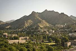
At an average height of 610 meters above sea level, Meghri is located near the Armenia-Iran border, on the shores of Meghri River, dominated by Zangezur Mountains from the northeast, and Meghri range from the southwest.
The town is mainly divided into 2 large neighborhoods:
- Mets tagh meaning the large neighborhood, located on the left bank of Meghri river, it occupies the eastern part of Meghri. Formed during the 17th century, it occupies around 70% of the town's area.
- Pokr tagh meaning the small neighborhood, located on the right bank of Meghri river, it occupies the western part of Meghri. It was formed during the Soviet days in the 20th century.
The 2 neighborhoods are separated by the Meghri river and Adelyan Street.
The surrounding areas of the town are designated as a Prime Butterfly Area,[6] having number of rare and endangered species of butterflies, such as Gegenes nostradamus, Papilio alexanor, Cupido argiades, Polyommatus damonides, and others.
Climate
The climate here is classified as BSk by the Köppen-Geiger system.
| Climate data for Meghri, Armenia | |||||||||||||
|---|---|---|---|---|---|---|---|---|---|---|---|---|---|
| Month | Jan | Feb | Mar | Apr | May | Jun | Jul | Aug | Sep | Oct | Nov | Dec | Year |
| Average high °C (°F) | 4.5 (40.1) |
6.6 (43.9) |
12.2 (54.0) |
18.7 (65.7) |
23.9 (75.0) |
28.7 (83.7) |
31.7 (89.1) |
32.0 (89.6) |
27.3 (81.1) |
20.9 (69.6) |
12.8 (55.0) |
6.7 (44.1) |
18.8 (65.9) |
| Average low °C (°F) | −3.4 (25.9) |
−1.8 (28.8) |
2.3 (36.1) |
7.4 (45.3) |
12.0 (53.6) |
15.9 (60.6) |
19.2 (66.6) |
18.2 (64.8) |
14.2 (57.6) |
9.1 (48.4) |
3.5 (38.3) |
−1.0 (30.2) |
8.0 (46.4) |
| Average precipitation mm (inches) | 21 (0.8) |
22 (0.9) |
30 (1.2) |
46 (1.8) |
56 (2.2) |
27 (1.1) |
9 (0.4) |
12 (0.5) |
15 (0.6) |
27 (1.1) |
26 (1.0) |
20 (0.8) |
311 (12.4) |
| Source: http://en.climate-data.org/location/21612/ | |||||||||||||
Demographics
Meghri is almost entirely populated by Armenians who belong to the Armenian Apostolic Church. The Church of the Holy Mother of God of Meghri of the large neighborhood opened in 1673, is the main church of the town. It is under the jurisdiction of the Diocese of Syunik based in Goris.
Here is the population timeline of Meghri since 1831:[2]
| Historical population | |||||||||||||||||||||||||||||||||||
|---|---|---|---|---|---|---|---|---|---|---|---|---|---|---|---|---|---|---|---|---|---|---|---|---|---|---|---|---|---|---|---|---|---|---|---|
|
|
| |||||||||||||||||||||||||||||||||
Culture
%2C_2013.08.25_-_panoramio_(1).jpg)
Meghri has a public library founded in 1882. The municipality also runs the cultural centre and the children's school of art. A branch of Yerevan fine arts teaching centre was opened in Meghri in 1985.
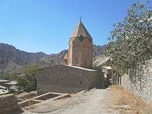
The remains of Meghri Fortress dating back to the 11th century are found at the eastern heights of the town. In addition to the Holy Mother of God Church of 1673, the 17th century Surp Hovhannes church located in the small neighborhood is also active and famous for its wall paintings. The abandoned church of Surp Sarkis located at the north of Meghri, is also dating back to the 17the century.
Transportation

Meghri is the main gate between Armenia and Iran through the nearby Agarak border crossing. The M-2 road that connects the capital Yerevan with Iran, passes through Meghri.
During the Soviet days, Meghri was connected with Yerevan by railway passing through the Nakhichevan Autonomous Soviet Socialist Republic. After the dissolution of Soviet Union and as a result of the military crisis between Armenia and Azerbaijan, the railroad became abandoned.
Economy
The town's economy is based on food industry, which contains a bread-baking factory, canneries and small home-based wineries. Meghri used to have a large wine factory during the Soviet years.
Agriculture is among the leading sectors in the region. Meghri is the only location in Armenia that produces pomegranate. The region is also known for its high-quality fig. Meghri has a significantly milder climate than the rest of the cities in Armenia, and produces fruits not found in other parts of the country.
The Iran-Armenia Natural Gas Pipeline passes through Meghri. In early 2007, it was reported that the governments of Armenia, Russia, and Iran are planning to build an oil refinery for gasoline export to Iran. This US$1.7 billion project would be led by Gazprom[7] whose Armenian subsidiary is already the country's main energy supplier[8] though in 2016 a new agreement opened up the possibility of having Meghri area's domestic gas supply (around 5000 households[9]) to be provided by Iranian company Sanergy.[10]
The Meghri Dam (also known as the Meghri hydroelectric project or Aras Watershed Dam) is a hydroelectric system planned on the Aras River, also known as Araxes, near Meghri on the Armenia–Iran border. The construction was to have begun in 2012. The joint project was proposed and discussed earlier in the 1990s between Iranian and Armenian authorities.[11][12]
In June 2016, the Meghri Medical Center was opened with the presence of then-president Serzh Sargsyan.[13]
Education
As of 2017, Meghri is home to 2 public high schools. It also has a pre-school kindergarten ran by the municipality. In 2001, an intermediate technical college was opened in Meghri, preparing teachers, accountants and mechanists.
Sport
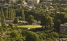
Meghri has a sports school served by a football training field and 2 swimming pools located at the centre of the city in the small neighborhood, on the right bank of Meghri river.
Notable people
- Yohannes Gugarats
- Paramaz, Armenian fedayee and political activist
- Khachatur Malumian, writer and political activist, victim of the Armenian Genocide
See also
References
- 2011 Armenia census, Syunik Province
- "Հայաստանի Հանրապետության բնակավայրերի բառարան [Dictionary of settlements of the Republic of Armenia]" (PDF). Armenian State Cadaste. 2008. p. 138.
- Նախատեսվում է իրականացնել համայնքների խոշորացման 14 պիլոտային ծրագիր
- "Archived copy" Капан (in Russian). abp.am. Archived from the original on 5 May 2010. Retrieved 28 August 2009.CS1 maint: archived copy as title (link)
- Kars and Erzeroum; with the campaigns of Prince Paskiewitch, in 1828 and 1829. Beown, Green & Longmans. 1856. p. 63.
- Butterfly Conservation Armenia http://www.butterfly-conservation-armenia.org/meghri.html
- Refinery idea mooted
- Gazprom Armenia buys the last section of Armenian pipeline that they hadn't previously owned
- Details of the Sanergy project
- Sanergy to provide Meghri's domestic gas network, under supervision of Gazprom Armenia
- [construction_of_meghri_hpp_on_river_arax_will_start_in_2014_minister HPP station plans, 2014]
- Moradi, Shima (28 June 2004). "Bitaraf Lauds Iran-Armenia Cooperation". Shana. Archived from the original on 26 July 2011. Retrieved 29 January 2011.
- "Working visit of President Serzh Sargsyan to Syunik marz - Press releases - Updates - The President of the Republic of Armenia [the official site]". m.president.am. 2 June 2016. Retrieved 5 April 2018.
| Wikimedia Commons has media related to Meghri. |