Garfield Township, Mackinac County, Michigan
Garfield Township is a civil township of Mackinac County in the U.S. state of Michigan. The population was 1,146 at the 2010 census.[3]
Garfield Township, Michigan | |
|---|---|
%2C_MI_location2.png) Location within Mackinac County | |
 Garfield Township Location within the state of Michigan | |
| Coordinates: 46°08′40″N 85°30′23″W | |
| Country | United States |
| State | Michigan |
| County | Mackinac |
| Government | |
| • Supervisor | Donald Butkovitch |
| Area | |
| • Total | 137.4 sq mi (355.8 km2) |
| • Land | 134.1 sq mi (347.4 km2) |
| • Water | 3.2 sq mi (8.4 km2) |
| Elevation | 663 ft (202 m) |
| Population (2010) | |
| • Total | 1,146 |
| • Density | 8.3/sq mi (3.2/km2) |
| Time zone | UTC-5 (Eastern (EST)) |
| • Summer (DST) | UTC-4 (EDT) |
| ZIP code(s) | |
| Area code(s) | 906 |
| FIPS code | 26-31620[1] |
| GNIS feature ID | 1626339[2] |
Communities
- Engadine (/ˈɛŋɡədaɪn/ EN-gə-dain) is an unincorporated community at 46°07′00″N 85°34′15″W on M-117 at the junction with H-40 (Hiawatha Trail), and approximately one mile (1.6 km) north of the southern terminus of M-117 (Michigan highway) at US 2.[4] It is approximately three miles (4.8 km) west of Millecoquins and four miles (6.4 km) east of Gould City. It began as a lumber settlement called "Kennedy Siding" and was given a post office in August 1889. In December 1893, a railroad agent named Sam Peterson, who was a native of Switzerland, had the name changed to Engadine after the scenic Swiss valley.[5] The Engadine ZIP code 49827 serves the western and central portions of Garfield Township as well portions of Portage Township and Newton Township.[6]
- Gilchrist is an unincorporated community at 46°08′34″N 85°23′05″W on H-40 (Hiawatha Trail), approximately six miles (9.7 km) east of Millecoquins and 3.5 miles (5.6 km) west of Garnet.[7] It was a lumber settlement with a station on the Minneapolis, St. Paul and Sault Ste. Marie Railroad. A post office operated from September 1879 to June 1883 and again from June 1888 until November 1906. It was named for John Gilchrist, a local landowner.[5]
- Millecoquins is an unincorporated community at 46°08′07″N 85°30′27″W on H-40 (Hiawatha Trail), approximately three miles (4.8 km) east of Engadine and 9.5 miles (15.3 km) west of Garnet. It is on the southern end of Millecoquins Lake, which divides the upper and lower segments of the Millecoquins River.[8] The name Millecoquins (pronounced "mel-a-coke-ins)" is a French word meaning "a thousand thieves", which was derived from the Indian terms Manana koking or Minakoking, meaning a place where the hardwood is plentiful.[5]
- Naubinway is an unincorporated community at 46°05′33″N 85°26′51″W on US 2 approximately six miles (9.7 km) east of the junction with M-117 and 15 miles (24 km) west of Epoufette along the Lake Michigan shore.[9] [Knob-in-way] Originally a lumbering town, the name derives from an Indian term meaning "place of echoes". A post office was established in November 1879.[5] The Naubinway ZIP code 49762 serves the southern and eastern portions of Garfield Township, as well as all of Hudson Township, most of Hendricks Township, and a portion of Moran Township.[10] Naubinway is known as the home of the Garlyn Zoo. Naubinway Island lies a half mile south of the community.
Geography
According to the United States Census Bureau, the township has a total area of 137.4 square miles (356 km2), of which 134.1 square miles (347 km2) is land and 3.2 square miles (8.3 km2), or 2.36%, is water.
At a roadside park, approximately 3 miles (5 km) east of Naubinway at 46°05′50″N 85°23′51″W,[11] a historical marker was erected in 1965 to commemorate the northernmost point of Lake Michigan, which is located approximately 1 mile (1.6 km) west of the park. This point is significant because it marked the original western boundary of Michigan Territory as established by the U.S. Congress in 1805. The boundary ran through the center of Lake Michigan to the northernmost extremity, and from thence due north to the northern boundary of the United States. In 1818, the boundary was extended west to the Mississippi River to encompass all the territory of the original Northwest Territory that had not yet been admitted as a state of the Union.[12]
History
The early years
Although the first white man may have passed through the Naubinway and Engadine area, perhaps as early as 1640, the area's recorded history did not begin until some 200 years later. The first permanent settlers to the area, the William Boucher family, came from Mackinac Island to trade furs with the Ojibway Indians. They built their first house on the "Point" (near the location of the new Naubinway Marina) and remained until approximately 1857.
It was not until March 10, 1873, that William Boucher received a deed from the federal government to 27.30 acres (110,500 m2) of land in Naubinway. His deed was signed by President Ulysses S Grant, and under the provisions of the Public Land Act of 1820, he could have paid as little as $1.25 per acre. In the sale Boucher obtained the title to "The lot numbered Four of Section twenty-eight in Township forty-tree of Range Nine west...subject to sale at Marquette, MI."
Commercial fishing
There is a tendency to believe that commercial fishing arrived on the scene in the nick of time to save the people in Naubinway from an economic plight brought about when the lumber industry collapsed. In fact, both industries existed simultaneously, for as far back as the late 1880s 34 fishing tugs operated out of Naubinway.
Demographics
As of the census[1] of 2000, there were 1,251 people, 550 households, and 382 families residing in the township. The population density was 9.3 per square mile (3.6/km²). There were 1,029 housing units at an average density of 7.7 per square mile (3.0/km²). The racial makeup of the township was 82.09% White, 0.08% African American, 12.47% Native American, 0.16% Asian, 0.48% from other races, and 4.72% from two or more races. Hispanic or Latino of any race were 1.36% of the population.
There were 550 households out of which 22.9% had children under the age of 18 living with them, 62.4% were married couples living together, 5.5% had a female householder with no husband present, and 30.4% were non-families. 26.7% of all households were made up of individuals and 13.1% had someone living alone who was 65 years of age or older. The average household size was 2.27 and the average family size was 2.73.
In the township the population was spread out with 19.5% under the age of 18, 5.2% from 18 to 24, 22.5% from 25 to 44, 29.4% from 45 to 64, and 23.4% who were 65 years of age or older. The median age was 47 years. For every 100 females, there were 95.8 males. For every 100 females age 18 and over, there were 96.7 males.
The median income for a household in the township was $34,712, and the median income for a family was $37,917. Males had a median income of $29,821 versus $26,146 for females. The per capita income for the township was $17,315. About 7.1% of families and 10.0% of the population were below the poverty line, including 8.1% of those under age 18 and 12.6% of those age 65 or over.
Transportation
Indian Trails provides daily intercity bus service via Engadine between St. Ignace and Ironwood, Michigan.[13]
References
- "U.S. Census website". United States Census Bureau. Retrieved 2008-01-31.
- U.S. Geological Survey Geographic Names Information System: Garfield Township, Mackinac County, Michigan
- "Profile of General Population and Housing Characteristics: 2010 Demographic Profile Data (DP-1): Garfield township, Mackinac County, Michigan". United States Census Bureau. Retrieved January 13, 2012.
- U.S. Geological Survey Geographic Names Information System: Engadine, Michigan
- Romig, Walter (1986) [1973]. Michigan Place Names. Detroit, Michigan: Wayne State University Press. ISBN 0-8143-1838-X.
- 49827 5-Digit ZCTA, 498 3-Digit ZCTA - Reference Map - American FactFinder, U.S. Census Bureau, Census 2000
- U.S. Geological Survey Geographic Names Information System: Gilchrist, Michigan
- U.S. Geological Survey Geographic Names Information System: Millecoquins, Michigan
- U.S. Geological Survey Geographic Names Information System: Naubinway, Michigan
- 9762 5-Digit ZCTA, 497 3-Digit ZCTA - Reference Map - American FactFinder, U.S. Census Bureau, Census 2000
- U.S. Geological Survey Geographic Names Information System: Naubinway Rest Area
- Northernmost Point of Lake Michigan, Michigan Historical Markers
- "ST. IGNACE-SAULT STE. MARIE-IRONWOOD" (PDF). Indian Trails. January 15, 2013. Archived from the original (PDF) on 2014-07-04. Retrieved 2013-02-28.
Municipalities and communities of Mackinac County, Michigan, United States | ||
|---|---|---|
| Cities | 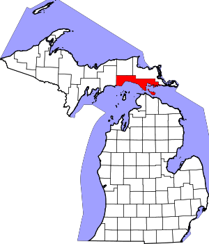 Map of Michigan highlighting Mackinac County.svg | |
| Civil townships | ||
| Unincorporated communities |
| |
| Indian reservations | ||
| Footnotes | ‡This populated place also has portions in an adjacent county or counties | |