Fujiyoshida, Yamanashi
Fujiyoshida (富士吉田市, Fujiyoshida-shi) is a city located in Yamanashi Prefecture, Japan. As of 1 May 2019, the city had an estimated population of 48,782 in 19,806 households [1] and a population density of 400 persons per km2. The total area of the city is 121.74 square kilometres (47.00 sq mi).
Fujiyoshida 富士吉田市 | |
|---|---|
 Fujiyoshida montage | |
 Flag  Seal | |
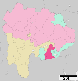 Location of Fujiyoshida in Yamanashi Prefecture | |
 Fujiyoshida | |
| Coordinates: 35°29′15.1″N 138°48′27.9″E | |
| Country | Japan |
| Region | Chūbu (Tōkai) |
| Prefecture | Yamanashi Prefecture |
| Government | |
| • Mayor | Shigeru Horiuchi |
| Area | |
| • Total | 121.74 km2 (47.00 sq mi) |
| Population (May 1, 2019) | |
| • Total | 48,782 |
| • Density | 400/km2 (1,000/sq mi) |
| Time zone | UTC+9 (Japan Standard Time) |
| City symbols | |
| • Tree | White birch |
| • Flower | Fujizakura |
| • Bird | Great spotted woodpecker |
| Phone number | 0555-22-1111 |
| Address | 6-1-1 Shimoyoshida, Fujiyoshida-shi, Yamanashi-ken 403-8601 |
| Website | Official website |


Geography
Fujiyoshida lies at the northern base of Mount Fuji, and is built upon old lava flows. It is considered a high-elevation city in Japan, at 2,140 to 2,800 feet above sea level. The city is also located between two of the Fuji Five Lakes. The Katsura River flows through the eastern part of the city.
Neighboring municipalities
- Yamanashi Prefecture
- Tsuru
- Minamitsuru District: Nishikatsura, Oshino, Yamanakako, Narusawa, Fujikawaguchiko
- Shizuoka Prefecture
Demographics
Per Japanese census data,[2] the population of Fujiyoshida peaked around the year 1990 and has been in slow decline since.
| Historical population | ||
|---|---|---|
| Year | Pop. | ±% |
| 1940 | 49,960 | — |
| 1950 | 61,882 | +23.9% |
| 1960 | 42,607 | −31.1% |
| 1970 | 50,046 | +17.5% |
| 1980 | 53,569 | +7.0% |
| 1990 | 54,804 | +2.3% |
| 2000 | 54,090 | −1.3% |
| 2010 | 50,612 | −6.4% |
Climate
The city has a climate characterized by hot and humid summers, and relatively mild winters (Köppen climate classification Cfa). The average annual temperature in Fujiyoshida is 9.1 °C (48.4 °F). The average annual rainfall is 1,845 millimetres (72.6 in) with September as the wettest month. The temperatures are highest on average in August, at around 21 °C (70 °F), and lowest in January, at around −2.3 °C (27.9 °F).[3]
History
Following the Meiji restoration, the area around Fujiyoshida was organized into Minamitsuru District, Yamanashi per the cadastral reforms of July 22, 1878. With the establishment of the modern municipalities system on July 1, 1889, the villages of Mizuho, Akemi and Fukuchi were established. In 1939, Mizuho was raised to town status and renamed Shimoyoshida. Likewise, in 1947, Fukuchi was raised to town status and renamed Fujikamiyoshida and Akemi was raised to town status in 1948, retaining its original name. These three towns merged on March 20, 1951, to form the city of Fujiyoshida.
Government
Fujiyoshida has a mayor-council form of government with a directly elected mayor and a unicameral city legislature of 20 members.
Economy
For several centuries, artisans around the Fujiyoshida area have produced high quality textiles,[4] and now the city is the center of commerce and high technology in southern Yamanashi Prefecture.
Education
- Showa University
- Fujiyoshida has seven public elementary schools and four public middle schools operated by the city government, and three public private high schools operated by the Yamanashi Prefectural Board of Education. The city also has one private middle school and one private high school.
Transportation
Railway

- Kotobuki - Yoshiikeonsenmae - Shimoyoshida - Gekkōji - Fujisan
Sister cities


Local attractions
- Kitaguchi Hongū Fuji Sengen Jinja, a Shinto shrine dedicated to the kami of Mount Fuji, the Kitaguchi Hongū Fuji Sengen Jinja is the historical starting point for pilgrims climbing the mountain. The main structure was originally built in 788 and underwent reconstruction in the 17th century. Additional buildings include a shrine dedicated to Takeda Shingen (1521–1573), and a red torii which is taken down and rebuilt every "Fuji Year" (60 years). The shrine has a local history museum which displays items from Fujiyoshida's past including household items, farm implements, clothing and samples of the cities' famous textiles.
- Fuji-Q Highland an amusement park with a variety of attractions suitable for adults and children.
- Mt. Fuji Visitors Center. It is home to interactive displays, videos, books and guides about Mount Fuji.
- Mt. Fuji Radar Dome Museum. A tribute to the meteorologists who built a radar research facility at the summit of Mt. Fuji, which features a room which simulates the conditions at the summit of the mountain.
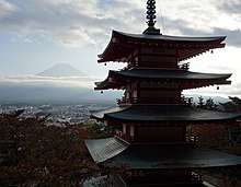
- Arakurayama Sengen Park and the Chūrei-tō pagoda, built on a hilltop facing Mt. Fuji.
Notable people from Fujiyoshida
- Keiji Mutoh, professional wrestler [6]
- Shun Sugata, actor[7]
References
- Fujiyoshida City official statistics(in Japanese)
- Fujiyoshida population statistics
- Fujiyoshida climate data
- "Fujiyoshida Welcomes You". Fujiyoshida City International Affairs Desk. Retrieved 17 January 2016.
- "International Exchange". List of Affiliation Partners within Prefectures. Council of Local Authorities for International Relations (CLAIR). Archived from the original on 5 February 2016. Retrieved 21 November 2015.
- "Player - Keiji Muto". Wrestle-1 Official Web Site (in Japanese). 2013. Archived from the original on 1 November 2014. Retrieved 17 January 2016.
- 日本映画人名事典』男優編. Kinema-Junpo. 1996. p. 832. ISBN 978-4873761886.
External links
![]()

- Official Website (in Japanese)
Kōfu (capital) | ||
| Core city | ||
| Cities | ||
| Districts |
| |
| Authority control |
|
|---|