Aiguille de Chambeyron
Aiguille de Chambeyron (3,412m) is a mountain of the Cottian Alps and is the highest mountain of Alpes-de-Haute-Provence in southeast France.[1] Together with its neighbour Brec de Chambeyron, it is the dominant peak of the upper Ubaye Valley. The mountain is located near the border with Italy, just west of the Main chain of the Alps. It is the culminating point of the Massif du Chambeyron and is also the highest peak in the Alps south of Monte Viso.[2]

The Chambeyron Massif, with Aiguille de chambeyron near left
| Aiguille de Chambeyron | |
|---|---|
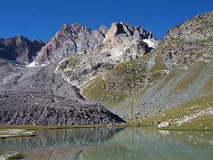 Aiguille de Chambeyron from Lake Marinet | |
| Highest point | |
| Elevation | 3,412 m (11,194 ft) |
| Prominence | 771 m (2,530 ft) [1] |
| Coordinates | 44°32′51″N 6°51′22″E [1] |
| Geography | |
 Aiguille de Chambeyron Location in the Alps | |
| Location | Provence-Alpes-Côte d'Azur, France |
| Parent range | Cottian Alps |
| Climbing | |
| First ascent | 1879[2] |
Aiguille de Chambeyron has two summits, with the west one being the slightly higher. Two small glaciers existed on its north side, although they have now all but vanished. W.A.B. Coolidge and Christian Almer were the first to climb Chambeyron in 1879.[2]
References
- "Aiguille de Chambeyron, France". Peakbagger.com. Retrieved 23 January 2015.
- "Aiguille-de-Chambeyron - Summitpost". Summitpost.org. Retrieved 23 January 2015.
This article is issued from Wikipedia. The text is licensed under Creative Commons - Attribution - Sharealike. Additional terms may apply for the media files.