Francisco León, Chiapas
Francisco León is one of the 119 Municipalities of Chiapas, in southern Mexico. It covers an area of 114.3 km². In 1982 parts of the municipality were buried in the eruption of El Chichón Volcano.
Francisco León | |
|---|---|
Municipality | |
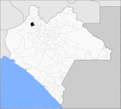 Municipality of Francisco León in Chiapas | |
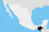
Francisco León Location in Mexico | |
| Coordinates: 17°19′N 93°15′W | |
| Country | |
| State | Chiapas |
| Area | |
| • Total | 114.3 km2 (44.1 sq mi) |
| Population (2010) | |
| • Total | 7,000 |
As of 2010, the municipality had a total population of 7,000,[1] up from 5,236 as of 2005.[2]
The municipality had 50 localities, the largest of which (with 2010 populations in parentheses) was: San Miguel la Sardina (1,106), classified as rural.[1]
References
- "Francisco León". Catálogo de Localidades. Secretaría de Desarrollo Social (SEDESOL). Retrieved 23 April 2014.
- "Francisco León". Enciclopedia de los Municipios de México. Instituto Nacional para el Federalismo y el Desarrollo Municipal / Gobierno del Estado de Chiapas. Archived from the original on June 17, 2011. Retrieved July 25, 2008.
This article is issued from Wikipedia. The text is licensed under Creative Commons - Attribution - Sharealike. Additional terms may apply for the media files.