Fountain, Michigan
Fountain is a village in Mason County in the U.S. state of Michigan. The population was 193 at the 2010 census. The village is within Sherman Township.
Fountain, Michigan | |
|---|---|
%2C_MI_location.png) Location within Mason County | |
 Fountain Location within the state of Michigan | |
| Coordinates: 44°02′46″N 86°10′46″W | |
| Country | United States |
| State | Michigan |
| County | Mason |
| Township | Sherman |
| Founded | 1882 |
| Incorporated | 1913 |
| Area | |
| • Total | 1.01 sq mi (2.6 km2) |
| • Land | 1.01 sq mi (2.6 km2) |
| • Water | 0.00 sq mi (0.0 km2) |
| Elevation | 709 ft (216 m) |
| Population | |
| • Total | 193 |
| • Estimate (2017)[3] | 196 |
| • Density | 191.1/sq mi (73.8/km2) |
| Time zone | UTC-5 (Eastern (EST)) |
| • Summer (DST) | UTC-4 (EDT) |
| ZIP code(s) | 49410 |
| Area code(s) | 231 |
| FIPS code | 26-29940[4] |
| GNIS feature ID | 1619960[5] |
Geography
According to the United States Census Bureau, the village has a total area of 1.01 square miles (2.62 km2), all land.[6]
History
Fountain was founded in 1882 when the railroad was extended to that point.[7] The village was so named on account of there being a spring near the original town site.[8] The village was incorporated in 1913.[7]
Demographics
| Historical population | |||
|---|---|---|---|
| Census | Pop. | %± | |
| 1920 | 222 | — | |
| 1930 | 223 | 0.5% | |
| 1940 | 235 | 5.4% | |
| 1950 | 247 | 5.1% | |
| 1960 | 194 | −21.5% | |
| 1970 | 156 | −19.6% | |
| 1980 | 195 | 25.0% | |
| 1990 | 165 | −15.4% | |
| 2000 | 175 | 6.1% | |
| 2010 | 193 | 10.3% | |
| Est. 2017 | 196 | [3] | 1.6% |
| U.S. Decennial Census[9] | |||
2010 census
As of the census[2] of 2010, there were 193 people, 71 households, and 48 families residing in the village. The population density was 191.1 inhabitants per square mile (73.8/km2). There were 83 housing units at an average density of 82.2 per square mile (31.7/km2). The racial makeup of the village was 91.7% White, 3.1% Asian, and 5.2% from two or more races. Hispanic or Latino of any race were 3.6% of the population.
There were 71 households of which 31.0% had children under the age of 18 living with them, 49.3% were married couples living together, 8.5% had a female householder with no husband present, 9.9% had a male householder with no wife present, and 32.4% were non-families. 21.1% of all households were made up of individuals and 7% had someone living alone who was 65 years of age or older. The average household size was 2.72 and the average family size was 3.15.
The median age in the village was 37.8 years. 26.9% of residents were under the age of 18; 8.4% were between the ages of 18 and 24; 25.9% were from 25 to 44; 29% were from 45 to 64; and 9.8% were 65 years of age or older. The gender makeup of the village was 53.9% male and 46.1% female.
2000 census
As of the census[4] of 2000, there were 175 people, 71 households, and 47 families residing in the village. The population density was 173.7 per square mile (66.9/km²). There were 89 housing units at an average density of 88.3 per square mile (34.0/km²). The racial makeup of the village was 97.14% White, 1.14% Native American, 0.57% from other races, and 1.14% from two or more races. Hispanic or Latino of any race were 0.57% of the population.
There were 71 households out of which 26.8% had children under the age of 18 living with them, 50.7% were married couples living together, 9.9% had a female householder with no husband present, and 32.4% were non-families. 31.0% of all households were made up of individuals and 12.7% had someone living alone who was 65 years of age or older. The average household size was 2.46 and the average family size was 2.90.
In the village, the population was spread out with 23.4% under the age of 18, 12.6% from 18 to 24, 27.4% from 25 to 44, 23.4% from 45 to 64, and 13.1% who were 65 years of age or older. The median age was 37 years. For every 100 females, there were 92.3 males. For every 100 females age 18 and over, there were 91.4 males.
The median income for a household in the village was $30,000, and the median income for a family was $50,938. Males had a median income of $31,875 versus $21,875 for females. The per capita income for the village was $19,396. About 3.9% of families and 5.5% of the population were below the poverty line, including none of those under the age of eighteen and 18.8% of those sixty five or over.
References
- "2017 U.S. Gazetteer Files". United States Census Bureau. Retrieved Jan 3, 2019.
- "U.S. Census website". United States Census Bureau. Retrieved 2012-11-25.
- "Population and Housing Unit Estimates". Retrieved March 24, 2018.
- "U.S. Census website". United States Census Bureau. Retrieved 2008-01-31.
- "US Board on Geographic Names". United States Geological Survey. 2007-10-25. Retrieved 2008-01-31.
- "Michigan: 2010 Population and Housing Unit Counts 2010 Census of Population and Housing" (PDF). 2010 United States Census. United States Census Bureau. September 2012. p. 32 Michigan. Retrieved April 12, 2020.
- Chancellor, V. H. Mrs. (Jun 16, 1934). "History of Fountain". Ludington Daily News. p. 2. Retrieved 2 December 2015.
- Surrarrer, G. Pearl (Jun 16, 1949). "Place names of county make interesting story". Ludington Daily News. p. 7. Retrieved 16 October 2015.
- "Census of Population and Housing". Census.gov. Retrieved June 4, 2015.
Municipalities and communities of Mason County, Michigan, United States | ||
|---|---|---|
| Cities | 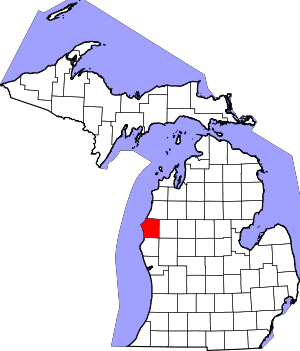 Map of Michigan highlighting Mason County.svg | |
| Villages | ||
| Charter township | ||
| Civil townships | ||
| Indian reservation | ||
| Footnotes | ‡This populated place also has portions in an adjacent county or counties | |
| Authority control |
|
|---|