Fallowfield Township, Washington County, Pennsylvania
Fallowfield Township is a township in Washington County, Pennsylvania, United States. The population was 4,321 at the 2010 census.[4]
Fallowfield Township | |
|---|---|
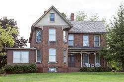 The John H. Nelson House, a historic site in the township | |
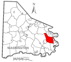 Location of Fallowfield Township in Washington County | |
 Location of Washington County in Pennsylvania | |
| Country | United States |
| State | Pennsylvania |
| County | Washington County |
| Area | |
| • Total | 21.32 sq mi (55.22 km2) |
| • Land | 21.27 sq mi (55.09 km2) |
| • Water | 0.05 sq mi (0.12 km2) |
| Population (2010) | |
| • Total | 4,321 |
| • Estimate (2018)[2] | 4,171 |
| • Density | 198.90/sq mi (76.80/km2) |
| Time zone | UTC-4 (EST) |
| • Summer (DST) | UTC-5 (EDT) |
| Area code(s) | 724 |
| Historical population | |||
|---|---|---|---|
| Census | Pop. | %± | |
| 2000 | 4,461 | — | |
| 2010 | 4,321 | −3.1% | |
| Est. 2018 | 4,171 | [2] | −3.5% |
| U.S. Decennial Census[3] | |||
History
Fallowfield is named for Lancelot Fallowfield, one of the first purchasers of land from William Penn.[5]
The John H. Nelson House was listed on the National Register of Historic Places in 2000.[6]
Geography
According to the United States Census Bureau, the township has a total area of 21.3 square miles (55 km2), of which, 21.3 square miles (55 km2) of it is land and 0.04 square miles (0.10 km2) of it (0.19%) is water.
Surrounding neighborhoods
Fallowfield Township has nine land borders, including Carroll Township to the north, North Charleroi, Charleroi and Twlight to the east, California and West Pike Run Township to the south, Bentleyville to the southwest, Somerset Township from the west to northwest and Nottingham Township to the north-northwest. A short segment of Fallowfield Township in the northeast corner runs adjacent with Monessen across the Monongahela River in Westmoreland County,
Demographics
At the 2000 census there were 4,461 people, 1,765 households, and 1,313 families living in the township. The population density was 209.6 people per square mile (80.9/km²). There were 1,878 housing units at an average density of 88.2/sq mi (34.1/km²). The racial makeup of the township was 97.85% White, 1.43% African American, 0.07% Native American, 0.16% Asian, 0.07% from other races, and 0.43% from two or more races. Hispanic or Latino of any race were 0.63%.[7]
Of the 1,765 households 24.9% had children under the age of 18 living with them, 63.6% were married couples living together, 7.8% had a female householder with no husband present, and 25.6% were non-families. 22.3% of households were one person and 12.0% were one person aged 65 or older. The average household size was 2.50 and the average family size was 2.92.
The age distribution was 18.4% under the age of 18, 7.3% from 18 to 24, 24.6% from 25 to 44, 28.8% from 45 to 64, and 20.8% 65 or older. The median age was 45 years. For every 100 females there were 95.5 males. For every 100 females age 18 and over, there were 93.3 males.
The median household income was $41,943 and the median family income was $45,750. Males had a median income of $36,102 versus $29,159 for females. The per capita income for the township was $18,565. About 3.6% of families and 4.1% of the population were below the poverty line, including 2.7% of those under age 18 and 5.4% of those age 65 or over.
References
- "2016 U.S. Gazetteer Files". United States Census Bureau. Retrieved Aug 14, 2017.
- Bureau, U. S. Census. "U.S. Census website". United States Census Bureau. US Census Bureau. Retrieved 1 December 2019.
- "Census of Population and Housing". Census.gov. Retrieved June 4, 2016.
- "U.S. Census website". United States Census Bureau. Retrieved 2017-03-11.
- Gannett, Henry (1905). The Origin of Certain Place Names in the United States. Govt. Print. Off. pp. 112.
- "National Register Information System". National Register of Historic Places. National Park Service. July 9, 2010.
- "U.S. Census website". United States Census Bureau. Retrieved 2008-01-31.
Pittsburgh metropolitan area | ||
|---|---|---|
| Counties |  Map of the Pittsburgh Tri-State with green counties in the metropolitan area and yellow counties in the combined area. | |
| Major cities | ||
| Cities and towns 15k–50k (in 2010) | ||
| Airports | ||
| Topics | ||
| ||