Escárcega
Escárcega (Spanish pronunciation: [esˈkaɾseɣa]) is a small city in the Mexican state of Campeche, located at 18.62°N 90.74°W in the central part of the state. As of 2010, the city of Escárcega had a population of 29,477.[1]
Escárcega | |
|---|---|
 | |
 Escárcega Escárcega | |
| Coordinates: 18°36′24″N 90°44′04″W | |
| Country | |
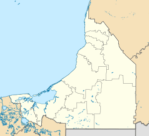
| State | Campeche |
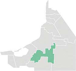
| Municipality | Escárcega |
| Ejido | 5 July 1939 |
| Town status | 1956 |
| City status | 19 July 1990 |
| Elevation | 85 m (279 ft) |
| Population (2010) | |
| • Total | 29,477 |
| Time zone | UTC−6 (Central (US Central)) |
| • Summer (DST) | UTC−5 (Central) |
| Postal code | 24350 |
| Area code(s) | 982 |
The city serves as the administrative centre for the surrounding municipality of the same name, which includes the city and its hinterland. In 2010 the population of Escárcega municipality was 54,184.[1] Its area is 4,569.64 km² (1,764.35 sq mi), which includes many smaller outlying communities, the largest of which is called División del Norte.
Escárcega is at the junction of Mexican Federal Highways 251 and 186, and is crossed by the railway that runs from Coatzacoalcos, Veracruz, to Campeche, Campeche. It is a new city that grew up in the 20th century with the arrival of the railways and roads. It is named after Francisco Escárcega, a native of Tlaxcala who fought in the Mexican Revolution and oversaw the construction of much of the rail network in the country's southeast.
Climate
| Climate data for Escárcega (1951–2010) | |||||||||||||
|---|---|---|---|---|---|---|---|---|---|---|---|---|---|
| Month | Jan | Feb | Mar | Apr | May | Jun | Jul | Aug | Sep | Oct | Nov | Dec | Year |
| Record high °C (°F) | 40.0 (104.0) |
39.0 (102.2) |
44.0 (111.2) |
44.0 (111.2) |
44.0 (111.2) |
42.0 (107.6) |
42.5 (108.5) |
40.0 (104.0) |
40.0 (104.0) |
39.5 (103.1) |
38.0 (100.4) |
38.0 (100.4) |
44.0 (111.2) |
| Average high °C (°F) | 29.5 (85.1) |
31.7 (89.1) |
34.2 (93.6) |
37.0 (98.6) |
37.4 (99.3) |
35.6 (96.1) |
34.9 (94.8) |
34.5 (94.1) |
33.6 (92.5) |
31.7 (89.1) |
30.4 (86.7) |
29.2 (84.6) |
33.3 (91.9) |
| Daily mean °C (°F) | 23.1 (73.6) |
24.5 (76.1) |
26.7 (80.1) |
28.9 (84.0) |
29.7 (85.5) |
28.9 (84.0) |
28.1 (82.6) |
27.9 (82.2) |
27.4 (81.3) |
25.8 (78.4) |
24.5 (76.1) |
23.2 (73.8) |
26.6 (79.9) |
| Average low °C (°F) | 16.7 (62.1) |
17.4 (63.3) |
19.1 (66.4) |
20.9 (69.6) |
22.0 (71.6) |
22.1 (71.8) |
21.4 (70.5) |
21.3 (70.3) |
21.2 (70.2) |
20.0 (68.0) |
18.6 (65.5) |
17.2 (63.0) |
19.8 (67.6) |
| Record low °C (°F) | 4.0 (39.2) |
5.0 (41.0) |
7.0 (44.6) |
9.5 (49.1) |
13.0 (55.4) |
13.0 (55.4) |
16.0 (60.8) |
15.0 (59.0) |
15.0 (59.0) |
10.0 (50.0) |
8.0 (46.4) |
6.0 (42.8) |
4.0 (39.2) |
| Average precipitation mm (inches) | 46.0 (1.81) |
38.9 (1.53) |
24.4 (0.96) |
36.7 (1.44) |
94.0 (3.70) |
211.1 (8.31) |
177.8 (7.00) |
270.2 (10.64) |
308.2 (12.13) |
197.7 (7.78) |
86.0 (3.39) |
46.5 (1.83) |
1,537.5 (60.53) |
| Average precipitation days (≥ 0.1 mm) | 5.2 | 3.9 | 2.5 | 3.2 | 6.5 | 14.6 | 16.2 | 18.9 | 18.2 | 13.3 | 7.4 | 6.5 | 116.4 |
| Source: Servicio Meteorológico National[2][3] | |||||||||||||
References
- Link to tables of population data from Census of 2005 INEGI: Instituto Nacional de Estadística, Geografía e Informática
- Campeche Enciclopedia de los Municipios de México
- "Escárcega". Catálogo de Localidades. Secretaría de Desarrollo Social (SEDESOL). Retrieved 23 April 2014.
- "Estado de Campeche–Estacion: Escárcega (SMN)". NORMALES CLIMATOLÓGICAS 1951–2010 (in Spanish). Servicio Meteorológico National. Retrieved 12 May 2015.
- "Extreme Temperatures and Precipitation for Escárcega (SMN) 1943–2009" (in Spanish). Servicio Meteorológico Nacional. Retrieved 12 May 2015.
Campeche (capital) | ||
| Municipalities and (municipal seats) |  | |