Eldorado, Saskatchewan
Eldorado was a mining town located on Beaverlodge Lake in northern Saskatchewan, Canada. The original name was Beaverlodge. Originally established by the Eldorado Mining and Refining company, the town was later displaced by Uranium City. It housed miners, company families and related workers. A one-room school looked after elementary students up to grade six, after which students were bussed to Uranium City. Eldorado had its own air service of DC-3s and DC-4s, which supplemented commercial air service by Pacific Western Airlines. Air was the accepted mode of travel to and from Eldorado and Uranium City.[1] The nearby Beaverlodge Mine was in operation from 1953 until 1982.[2] Eldorado and Uranium City are along Saskatchewan Highway 962, an isolated stretch of highway.
Eldorado | |
|---|---|
Ghost Town | |
 Eldorado Location of Eldorado | |
| Coordinates: 59°33′02″N 108°30′06″W | |
| Country | |
| Province | |
| Region | Saskatchewan |
| Census division | Division No. 18 |
| Post Office Established | 1953-07-09 |
| Post Office Closed | 1982-07-20 |
| Time zone | CST |
| Postal code | S0H 2P0 & S0J 0T0 |
| Area code(s) | 306 |
The first post office was established in 1953 with John Edgar Hamlin as postmaster; E.A. (Ed) Garton was the postmaster from January 11, 1955, to April 29, 1970. The post office was closed July 20, 1982, with May A. Grona as the last postmaster.[3]
Geology
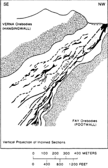
Uranium was discovered in the Beaverlodge District in 1946. The Eldorado Company's major production in the town area came from the Fay-Ace-Verna mine shafts, mostly from uranium deposits located in the Archaen Tazin Group. The deposits are found within the footwall and hanging wall of the St. Louis fault. [4][5]
Climate
| Climate data for Eldorado | |||||||||||||
|---|---|---|---|---|---|---|---|---|---|---|---|---|---|
| Month | Jan | Feb | Mar | Apr | May | Jun | Jul | Aug | Sep | Oct | Nov | Dec | Year |
| Average high °C (°F) | −21 (−5) |
−16 (3) |
−8 (17) |
3 (37) |
12 (53) |
18 (64) |
21 (69) |
19 (66) |
11 (51) |
3 (37) |
−7 (19) |
−17 (1) |
2 (34) |
| Daily mean °C (°F) | −26 (−14) |
−22 (−7) |
−14 (6) |
−3 (26) |
6 (42) |
13 (55) |
16 (60) |
14 (57) |
7 (44) |
0 (32) |
−11 (12) |
−22 (−7) |
−3 (26) |
| Average low °C (°F) | −31 (−23) |
−28 (−18) |
−21 (−5) |
−9 (15) |
0 (32) |
7 (44) |
10 (50) |
9 (48) |
3 (37) |
−2 (28) |
−15 (5) |
−26 (−14) |
−9 (17) |
| Source: weatherbase | |||||||||||||
References
- "Chapter 7. Uranium Mining in Northern Saskatchewan: A Public-Private Transition (Part 2)". International Development Research Centre. Archived from the original on 2011-06-09. Retrieved 2011-02-22.
- "Uranium Mining in Northern Saskatchewan". Canadian Nuclear Association. Retrieved 2011-02-22.
- "Post Offices and Postmasters database". Library and Archives Canada. Archived from the original on 2011-11-19. Retrieved 2011-02-22.
- Nash, J. Thomas (1981). Geology and genesis of major world hardrock uranium deposits: An overview, USGS Open-File Report 81-166. US Government. pp. 61–66.
- Lang, A.H. (1956). Record of Proceedings of Session 6B, Panel Discussion on Uranium and Thorium Occurrences, Peaceful Uses of Atomic Energy, Vol. 6, Geology of Uranium and Thorium. New York: United Nations. pp. 646–647.
Places adjacent to Eldorado, Saskatchewan | ||||||||||
|---|---|---|---|---|---|---|---|---|---|---|
| ||||||||||
