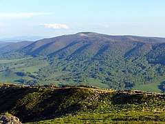
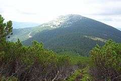
Eastern Beskids
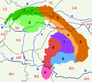
The Eastern Beskids or Eastern Beskyds (Ukrainian: Східні Бескиди; Polish: Beskidy Wschodnie; Rusyn: Выходны Бескиды; Romanian: Beskizii Orientali; Russian: Восточные Бескиды) are a geological group of mountain ranges of the Beskids, within the Outer Eastern Carpathians. As a continuation of the Central Beskids, this mountain range includes the far southeastern corer of Poland, the far eastern corner of Slovakia, and stretches southward through western parts of Ukraine, up to the border of Romania.[1][2]
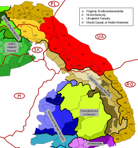
In Polish and Ukrainian terminology, the range is commonly called the "Eastern Beskids" (Ukrainian: Східні Бескиди; Polish: Beskidy Wschodnie), while in Slovakia, the term Meadowed Mountains (Slovak: Poloniny) is also used. The scope of those terms varies in accordance to different traditions and classifications.
At the three-way border, portions of the Slovak Bukovec Mountains (Slovak: Bukovské vrchy), the Polish Bieszczady Mountains (Polish: Bieszczady Zachodnie), and the adjacent "Uzhansky National Nature Park" and Nadsiansky Regional Landscape Park in Ukraine form the transnational East Carpathian Biosphere Reserve.
Subdivisions
.png)
The Eastern Beskids are commonly divided into two parallel ridges: Wooded Beskids and Polonynian Beskids.
Wooded Beskids (PL: Beskidy Lesiste; UA: Лісисті Бескиди):
- Bieszczady Mountains (PL: Bieszczady; UK: Бещади) → c1
- Western Bieszczady (PL: Bieszczady Zachodnie; UA: Західні Бещади) mainly in Poland and Slovakia, including the Bukovec Mountains (SK: Bukovské vrchy)
- Eastern Bieszczady (PL: Bieszczady Wschodnie; UA: Східні Бещади), mainly in Ukraine
- Sanok-Turka Mountains (PL: Góry Sanocko-Turczańskie; UK: Верхньодністровські Бескиди / Verkhnodnistrovski Beskydy) → c3
- Skole Beskids (PL: Beskidy Skolskie; UA: Сколівські Бескиди) → c2
- Gorgany (PL: Gorgany; UA: Ґорґани) → c4
- Pokuttia-Bucovina Beskids (PL: Beskidy Pokucko-Bukowińskie; UA: Покутсько-Буковинські Карпати / Pokutsko-Bukovinski Karpaty) → c5
Polonynian Beskids (PL: Beskidy Połonińskie; UA: Полонинські Бескиди):
- Smooth Polonyna (PL: Połonina Równa; UK: Полонина Рівна) → c6
- Polonyna Borzhava (PL: Połonina Borżawska; UK: Полонина Боржава) → c7
- Polonyna Kuk (PL: Połonina Kuk; UK: Полонина Кук) → c8
- Red Polonyna (PL: Połonina Czerwona; UK: Полонина Красна)→ c9
- Svydovets (PL: Świdowiec; UK: Свидівець) → c10
- Chornohora (PL: Czarnohora; UK: Чорногора) → c11
- Hrynyavy Mountains (PL: Połoniny Hryniawskie; UK: Гриняви) → c12
See also
References
Sources
- Földvary, Gábor Z. (1988). Geology of the Carpathian Region. Singapore: World Scientific Publishing Company.CS1 maint: ref=harv (link)
- Tasenkevich, Lydia (2009). "Polonynas: Highlands Pastures in the Ukrainian Carpathians". Grasslands in Europe: Of High Nature Value. Zeist: KNNV Publishing. pp. 203–208.CS1 maint: ref=harv (link)
External links
| Wikimedia Commons has media related to Eastern Beskids. |
- Encyclopedia of Ukraine: Inner Carpathian Valley
- Encyclopedia of Ukraine: Borzhava
- Encyclopedia of Ukraine: Krasna
- Encyclopedia of Ukraine: Svydivets
- Encyclopedia of Ukraine: Chornohora
- Carpathian Mountains: Division (map)
Divisions, Groups, and Ranges of the Carpathian Mountains | ||||||
|---|---|---|---|---|---|---|
| Western Carpathians |
|  | ||||
| Eastern Carpathians |
| |||||
| Southern Carpathians | ||||||
| Western Romanian Carpathians | ||||||
| Serbian Carpathians |
| |||||
| Adjacent regions |
| |||||
| Grouping by country |
| |||||