Chornohora
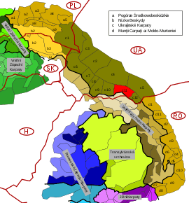
Chornohora (literally: Black Mountain, Ukrainian: Чорногора, Polish: Czarnohora, Hungarian: Feketebérc) is the highest mountain range in Western Ukraine. It is within the Polonynian Beskids, a subgroup of the mountain group of Eastern Beskids, which in turn is part of the Outer Eastern Carpathians.[1] [2]
Description
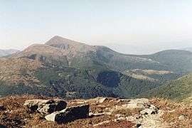
The range is located on the administrative border between Ivano-Frankivsk and Zakarpattia oblasts. It is adjacent to the Gorgany range. The highest peak of Chornohora is Hoverla (2,061 m) with other high peaks including Pip Ivan (2,022 m) and Petros (2,020 m). The mountains are made of flysch rock.
The major part of the range forms the watershed between the Prut and Tysa River. The lower parts of Chornohora are inhabited by Hutsuls, whose primary occupation is herding. Major tourist centres of Chornohora are Bystrets, Dzembronia, Rakhiv, Verkhovyna, Vorokhta and Yasinia.
In 1968 on the southern macroslope was established the Carpathian Biosphere Reserve, and in 1980 on the northern macroslope the Carpathian National Nature Park.
List of peaks
- Menchul
- Hoverla
- Pip Ivan
- Petros
- Hutyn Tomnatyk
- Staiky
- Homul
- Shuryn
- Pozhyzhevska
- Breskul
- Dantser
- Shpytsi
- Brebeneskul
- Rebra
- Turkul
See also
Sources
- Földvary, Gábor Z. (1988). Geology of the Carpathian Region. Singapore: World Scientific Publishing Company.CS1 maint: ref=harv (link)
- Tasenkevich, Lydia (2009). "Polonynas: Highlands Pastures in the Ukrainian Carpathians". Grasslands in Europe: Of High Nature Value. Zeist: KNNV Publishing. pp. 203–208.CS1 maint: ref=harv (link)
External links
| Wikimedia Commons has media related to Chornohora range. |