Durgapur Upazila, Rajshahi
Durgapur (দুর্গাপুর) is an Upazila of Rajshahi District in the Division of Rajshahi, Bangladesh. Durgapur Thana was formed in 1909 and it was turned into an upazila in 1984.
Durgapur দুর্গাপুর | |
|---|---|
Upazila | |
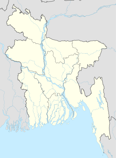
 Durgapur Location in Bangladesh | |
| Coordinates: 24°27.3′N 88°46′E | |
| Country | |
| Division | Rajshahi Division |
| District | Rajshahi District |
| Area | |
| • Total | 195.03 km2 (75.30 sq mi) |
| Population (1991) | |
| • Total | 137,640 |
| • Density | 710/km2 (1,800/sq mi) |
| Time zone | UTC+6 |
| Website | Durgapur |
Geography
Durgapur Upazila (RAJSHAHI DISTRICT) area 195.03 km2, located in between 24°23' and 24°32' north latitudes and in between 88°40' and 88°52' east longitudes. It is bounded by baghmara and mohanpur upazilas on the north, puthia upazila on the south and east, paba upazila on the west.
Demographics
According to 2011 Bangladesh census, Durgapur had a population of 185,845. Males constituted 50.34% of the population and females 49.66%. Muslims formed 97.28% of the population, Hindus 2.19%, Christians 0.36% and others 0.18%. Durgapur had a literacy rate of 48.23% for the population 7 years and above.[1]
According to the 1991 Bangladesh census, Durgapur's population was 137,640. Males constituted 50.81% of the population, females 49.19%. The population aged 18 and older was 71,446. Durgapur's average literacy rate was 20.2% (7+ years), compared to a national average of 32.54.[2]
Independence War
History of the War of Liberation. In 1971 a battle was fought between the freedom fighters and the Pakistani army at Kabasmul (border of Paba-Durgapur) in which a Pakistani army Major was killed; in retaliation the Pakistani army killed 44 innocent villagers of Gaganbaria and Palsa. Marks of War of Liberation Mass killing and memorial statue at the playground of Palsa School.
Administration
Durgapur has 7 Unions/Wards, 114 Mauzas/Mahallas, and 122 villages. Post Code- 6240.
Education
Literacy rate and educational institutions Average literacy 41%; male 46.8% female 34.8%. Educational institutions: College 9, technical college 3, secondary school 43, primary school 77, madrasa 19. Noted educational institutions: Durgapur Pilot High School (1946), Daudkandi High School (1946), Sreedhar Govt. Primary School (1857), Singa Govt. Primary School (1923), Bakhtiarpur High School, Laxman Khalshi Govt. Primary School.
Economy
Main sources of income Agriculture 79.85%, non-agricultural labourer 2.14%, industry 0.24%, commerce 7.92%, transport and communication 2.81%, service 3%, construction 0.45%, religious service 0.09%, rent and remittance 0.09% and others 3.41%.
Ownership of agricultural land Landowner 68.77%, landless 31.23%; agricultural landowner: urban 60.27%' and rural 69.11%.
Main crops Paddy, wheat, potato, betel nut, mulberry, vegetables.
Extinct or nearly extinct crops Sesame, mustard seed, sweet potato, kaun, linseed, arahar.
Main fruits Mango, jackfruit, banana, papaya, litchi, date.
Fisheries, dairies and poultries Fishery 50, poultry 20, hatchery 25.
Transportation
Communication facilities Pucca road 115 km, semi-pucca road 5.17 km, mud road 430.88 km. Extinct or nearly extinct traditional transport Palanquin, horse carriage and bullock cart.
Spectacular Place
Namudurkhi cluster
About 4 km from Durgapur upazila 3 km from North-West Corner and Deulayabari UP Previously the cluster is situated in the village. Durgapur Upazila or Deewaybari UP can be added directly to van car.
Panchbari five domed mosque
Going directly from Rajshahi Bhadra to auto rickshaw, it is possible to get direct van from Durgapur.
The house of Lakhanlakshi (Bakhtiarpur) Tamlai
Located 25 to 27 kilometers north-east of Rajshahi district and 4 kilometers from Durgapur upazila on the north-west side and south of southwestern and south-west of the river Daluwara. From the Rajshahi to the auto rickshaw directly.
Malanchi river
25 km away in the northeast of Rajshahi district and 4 km from Durgapur upazila and north-west of the upazila on the south of Deluubari union. From the Rajshahi to the auto rickshaw directly.
Jhaluka Mazar
The 5 Places of Jhaluka is a historic middle ground known as Jhaluka Mazar. This center is located about 15 kilometers east of the city of Rajshahi. From the Rajshahi city to the CNG-powered car, the Rajshahi Sugar Mills will reach the Amagachi market. CNG-powered car rental from Rajshahi city to Amagachi Bazar up to Tk 30 Then, if you go to the auto car or van car from Amagachi Bazar, 1 kilometer east then it is available in Jhaluka middle. From Amagachi Bazar to Jhaluka center, the car rental is 5 taka.
Kalachand Shah's middle Sharif
To get access to Rajshahi City, Bhadra will be coming to the railgate where auto rickshaw will be used for Hatkanpara Bazar. It will take time for the auto rickshaw to reach the full path only at 30–45 minutes at the Hatkhanpara College, and if you look east, you can see the middle and Durgapur upazila from Nachimon and Kariman to come to Hatkhanparara College will be seen at the moment before the middle of the middle. Kalachand Shah's middle Sharif, where every year 15,16 and 17th Maggh, his death came down to the tempestuous crowd of thousands of devotees coming from distant places. There are also different rituals performed at different times.
Historical mass grave
Auto rickshaw will be available for Hatkhanpara Bazar in the Bhadra Railgate to come from Rajshahi city. It will take time for the auto rickshaw to complete the full path only 15–45 minutes before reaching Hatkanpara Bazar Gaganbariya Azharara falls in the direction of the east, when we can see 100 yards forward east of the mass graveyard and Nichimon and Kariman from Durgapur upazila to come to Hatkanapara college crossroads 7 The road from there to van or auto rickshaw goes up to Gaganbariya Azhar If we look at 100 yards ahead, the mass grave can be seen.
Recreational Place
There has no specific recreational place but yearly arranged some week or day that is called Mela in Bangla. Few kinds of Mela arranged at every year and among them most of the popular is Ujalkhalshi Mela also known as "Ghora Dor" Mela.
Sports
People of Durgapur upazila are very sports-loving. Durgapur upazila has given birth to many notable sportsmen since ancient times . Various tournaments are held here every year. In today's popular game, cricket and football are dominated, but other games are not behind such as Volleyball, Badan Bouche, Cock Fight There are several playgrounds in Durgapur. Among them, Durgapur Pilot High School Ground, Durgapur Degree College Ground and various private high school grounds. The Khollaradars also play in different spots. When the rain came in the rain, Kadaya ground in the field of football, and the durin son's team.
Natural Resources
Durgapur upazila of Rajshahi district has no significant resources. So there is no list of any natural resources in Durgapur upazila. If the natural resources are found, the natural resources will be listed in Durgapur Upazila.
River & Water
Water bodies Hoja and Barnai rivers and' Angrar Beel, Kayamjampur Beel, Anulia Beel, Dahar Beel, Kaliar Padma Beel, Khaliar beel are notable.
Public Bazar
Hats, bazars and fairs Hats and bazars are 16, fairs 3, most noted of which are Durgapur Bazar, Daokandi Bazar, Pananagar Bazar, Kanpara Hat,' Baruni Snan Mela (Kalidaha), Tebila Muharram Mela (Pananagar), Lakshmipur Ghoradaha Mela.
Business
Noted manufactories Flour mill, rice mill, saw mill, printing press, ice factory, welding factory, bidi factory.
Major NGO's
NGO activities brac, asa, caritas, thengamara mahila sabuj sangha etc.
Newspaper
Some national and local newspaper are available for reading in Durgapur but there have no office for newspaper and even have no Durgapur based newspaper. Some national English newspaper also found for reading here.
See also
- Upazilas of Bangladesh
- Districts of Bangladesh
- Divisions of Bangladesh
References
- "Bangladesh Population and Housing Census 2011: Zila Report – Rajshahi" (PDF). Table P01 : Household and Population by Sex and Residence, Table P05 : Population by Religion, Age group and Residence, Table P09 : Literacy of Population 7 Years & Above by Religion, Sex and Residence. Bangladesh Bureau of Statistics (BBS), Ministry of Planning, Government of the People’s Republic of Bangladesh. Retrieved 9 December 2018.
- "Population Census Wing, BBS". Archived from the original on 2005-03-27. Retrieved November 10, 2006.
- AKM Kaisaruzzaman (2012). "Durgapur Upazila (Rajshahi District)". In Sirajul Islam and Ahmed A. Jamal (ed.). Banglapedia: National Encyclopedia of Bangladesh (Second ed.). Asiatic Society of Bangladesh.
