Bagmara Upazila
(Bengali: বাগমারা) is an Upazila of Rajshahi District in the Division of Rajshahi, Bangladesh.[1]
বাগমারা | |
|---|---|
Upazila | |
 বাগমারা Location in Bangladesh | |
| Coordinates: 24°33.8′N 88°48.5′E | |
| Country | |
| Division | Rajshahi Division |
| District | Rajshahi District |
| Area | |
| • Total | 363.3 km2 (140.3 sq mi) |
| Population (1991) | |
| • Total | 282,520 |
| • Density | 780/km2 (2,000/sq mi) |
| Time zone | UTC+6 (BST) |
| Website | bagmara |
Geography
Bagmara is located at 24.5639°N 88.8083°E . It has 57675 households and total area 363.3 km².
Demographics
According to 2011 Bangladesh census, Bagmara had a population of 354,664. Males constituted 49.95% of the population and females 50.05%. Muslims formed 95.31% of the population, Hindus 4.65% and others 0.04%. Bagmara had a literacy rate of 46.31% for the population 7 years and above.[2]
As of the 1991 Bangladesh census, Bagmara has a population of 282520. Males constitute 50.01% of the population, and females 49.99%. This Upazila's eighteen up population is 147768. Bagmara has an average literacy rate of 52.9% (7+ years), and the national average of 32.4% literate.[3]
Administration
Bagmara has 16 Unions/Wards, 295 Mauzas/Mahallas, and 362 villages. The unions of Bagmara thana are: 1. Shuvodanga 2. Basupara 3. Auchpara 4. Govindpara 5. Gonipur 6. Sonadanga 7. Jugipara 8. Nordash 9. Kacarikuolipara 10. Maria 11. Sreepur 12. Dippur 13. Borobihanoli 14. Hamirkutssa 15. Jhikra and 16. Ghoalkandi. 17.Holudghor Also Bagmara has 2 powroshova. 1.Taherpur powroshova & 2.Bhawanigong powroshova
Notable residents
- Abdus Sattar Mondal was Member of Parliament twice for constituencies encompassing Bagmara Upazila.
See also
- Upazilas of Bangladesh
- Districts of Bangladesh
- Divisions of Bangladesh
References
- Md Asadul Islam (2012), "Baghmara Upazila", in Sirajul Islam and Ahmed A. Jamal (ed.), Banglapedia: National Encyclopedia of Bangladesh (Second ed.), Asiatic Society of Bangladesh
- "Bangladesh Population and Housing Census 2011: Zila Report – Rajshahi" (PDF). Table P01 : Household and Population by Sex and Residence, Table P05 : Population by Religion, Age group and Residence, Table P09 : Literacy of Population 7 Years & Above by Religion, Sex and Residence. Bangladesh Bureau of Statistics (BBS), Ministry of Planning, Government of the People’s Republic of Bangladesh. Retrieved 9 December 2018.
- "Population Census Wing, BBS". Archived from the original on 2005-03-27. Retrieved November 10, 2006.
| Upazila/Thana: | ||
|---|---|---|
Headquarters: Rajshahi | ||
| Bogra District | 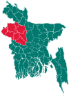 | |
| Joypurhat District | ||
| Naogaon District | ||
| Natore District | ||
| Nawabganj District | ||
| Pabna District | ||
| Rajshahi District | ||
| Sirajganj District | ||