Dexter Township, Michigan
Dexter Township is a civil township of Washtenaw County in the U.S. state of Michigan. The population was 6,042 at the 2010 census.[3] The nearby city of Dexter is not connected with the township and is located to the southeast.
Dexter Township, Michigan | |
|---|---|
 Township Hall on Dexter–Pinckney Road | |
 Location within Washtenaw County | |
 Dexter Township Location within the state of Michigan | |
| Coordinates: 42°24′09″N 83°57′04″W | |
| Country | United States |
| State | Michigan |
| County | Washtenaw |
| Established | 1827 |
| Government | |
| • Supervisor | Harley Rider |
| • Clerk | Debra Ceo |
| Area | |
| • Total | 33.2 sq mi (85.9 km2) |
| • Land | 30.3 sq mi (78.6 km2) |
| • Water | 2.8 sq mi (7.3 km2) |
| Elevation | 899 ft (274 m) |
| Population (2010) | |
| • Total | 6,042 |
| • Density | 180/sq mi (70/km2) |
| Time zone | UTC-5 (Eastern (EST)) |
| • Summer (DST) | UTC-4 (EDT) |
| ZIP code(s) | |
| Area code(s) | 734 |
| FIPS code | 26-22180[1] |
| GNIS feature ID | 1626184[2] |
| Website | Official website |
History
Dexter Township was one of the three original townships of Washtenaw County organized in 1827.
Communities
- Dover is a mostly historical settlement on the Huron River in the northeast part of the township at 42°24′09″N 83°54′39″W[4] Also known as Dover Mills, it was settled in 1833 and given a post office named Base Lake on August 30, 1849, with Moses Y. Hood as the first postmaster. In 1882, Thomas Birkett established the Birkett Manufacturing Company here and the post office was renamed Birkett on March 29, 1882, with Thomas Birkett as the first postmaster. The office continued until October 14, 1893.[5]
Geography
According to the United States Census Bureau, the township has a total area of 33.2 square miles (85.9 km2), of which 30.3 square miles (78.6 km2) is land and 2.8 square miles (7.3 km2), or 8.49%, is water.[6]
Demographics
As of the census[1] of 2000, there were 5,248 people, 1,863 households, and 1,488 families residing in the township. The population density was 170.6 per square mile (65.9/km2). There were 2,168 housing units at an average density of 70.5 per square mile (27.2/km2). The racial makeup of the township was 97.52% White, 0.38% African American, 0.29% Native American, 0.61% Asian, 0.06% Pacific Islander, 0.08% from other races, and 1.07% from two or more races. Hispanic or Latino of any race were 1.03% of the population.
There were 1,863 households, out of which 40.6% had children under the age of 18 living with them, 71.8% were married couples living together, 5.3% had a female householder with no husband present, and 20.1% were non-families. 16.1% of all households were made up of individuals, and 5.3% had someone living alone who was 65 years of age or older. The average household size was 2.80 and the average family size was 3.16.
In the township the population was spread out, with 28.5% under the age of 18, 5.6% from 18 to 24, 28.5% from 25 to 44, 29.2% from 45 to 64, and 8.3% who were 65 years of age or older. The median age was 38 years. For every 100 females, there were 102.3 males. For every 100 females age 18 and over, there were 100.7 males.
The median income for a household in the township was $75,085, and the median income for a family was $81,510. Males had a median income of $57,596 versus $34,219 for females. The per capita income for the township was $30,164. About 0.8% of families and 1.8% of the population were below the poverty line, including 0.9% of those under age 18 and 2.3% of those age 65 or over.
Gallery

 Inverness Inn, N. Territorial Rd.
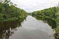 Huron River from bridge on N. Territorial Rd.
References
- "U.S. Census website". United States Census Bureau. Retrieved 2008-01-31.
- U.S. Geological Survey Geographic Names Information System: Dexter Township, Michigan
- "Profile of General Population and Housing Characteristics: 2010 Demographic Profile Data (DP-1): Dexter township, Washtenaw County, Michigan". United States Census Bureau. Retrieved July 9, 2012.
- U.S. Geological Survey Geographic Names Information System: Dover, Michigan
- Romig, Walter (1986) [1973]. Michigan Place Names. Detroit, Michigan: Wayne State University Press. ISBN 0-8143-1838-X.
- "Geographic Identifiers: 2010 Demographic Profile Data (DP-1): Dexter township, Washtenaw County, Michigan". United States Census Bureau. Retrieved July 9, 2012.
External links
Municipalities and communities of Washtenaw County, Michigan, United States | ||
|---|---|---|
| Cities |  Map of Michigan highlighting Washtenaw County | |
| Villages | ||
| Charter townships | ||
| Civil townships | ||
| CDPs | ||
| Other unincorporated communities |
| |
| Ghost towns | ||
| Footnotes | ‡This populated place also has portions in an adjacent county or counties | |
| Authority control |
|
|---|