Chelsea, Michigan
Chelsea is a city in Washtenaw County in the U.S. state of Michigan. The population was 4,944 at the 2010 census.[6]
Chelsea, Michigan | |
|---|---|
| City of Chelsea | |
 Downtown Chelsea and the clock tower | |
Seal | |
| Motto(s): A city of history, a city of pride | |
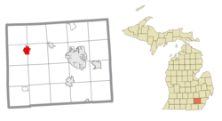 Location within Washtenaw County | |
 Chelsea Location within the state of Michigan | |
| Coordinates: 42°19′05″N 84°01′13″W | |
| Country | United States |
| State | Michigan |
| County | Washtenaw |
| Incorporated | 2004 |
| Government | |
| • Type | Council–manager |
| • Mayor | Melissa Johnson |
| • Clerk | Laura Kaiser |
| Area | |
| • Total | 3.67 sq mi (9.50 km2) |
| • Land | 3.62 sq mi (9.37 km2) |
| • Water | 0.05 sq mi (0.13 km2) |
| Elevation | 932 ft (284 m) |
| Population | |
| • Total | 5,056 |
| • Estimate (2019)[3] | 5,416 |
| • Density | 1,440.82/sq mi (556.25/km2) |
| Time zone | UTC-5 (Eastern (EST)) |
| • Summer (DST) | UTC-4 (EDT) |
| ZIP code(s) | 48118 |
| Area code(s) | 734 |
| FIPS code | 26-15020[4] |
| GNIS feature ID | 0623143[5] |
| Website | Official website |
In March 2004 by a 995-226 vote, residents approved a change in municipal status from a village into a city. Residents no longer pay property taxes to adjacent Lima and Sylvan townships as they had under the village government. The city provides all services formerly provided by both village and township governments.[7]
Geography
According to the United States Census Bureau, the city has a total area of 3.68 square miles (9.53 km2), of which 3.63 square miles (9.40 km2) is land and 0.05 square miles (0.13 km2) is water.[8]
Climate
This climatic region has large, varying seasonal temperature differences, with warm to hot (and often humid) summers and cold (sometimes severely cold) winters. According to the Köppen Climate Classification system, Chelsea has a humid continental climate, abbreviated "Dfb" on climate maps.[9]
Demographics
| Historical population | |||
|---|---|---|---|
| Census | Pop. | %± | |
| 1870 | 1,013 | — | |
| 1880 | 1,160 | 14.5% | |
| 1890 | 1,356 | 16.9% | |
| 1900 | 1,635 | 20.6% | |
| 1910 | 1,764 | 7.9% | |
| 1920 | 2,079 | 17.9% | |
| 1930 | 2,268 | 9.1% | |
| 1940 | 2,246 | −1.0% | |
| 1950 | 2,580 | 14.9% | |
| 1960 | 3,355 | 30.0% | |
| 1970 | 3,858 | 15.0% | |
| 1980 | 3,816 | −1.1% | |
| 1990 | 3,772 | −1.2% | |
| 2000 | 4,398 | 16.6% | |
| 2010 | 4,944 | 12.4% | |
| Est. 2019 | 5,416 | [3] | 9.5% |
| U.S. Decennial Census[10] | |||
2010 census
As of the census[2] of 2010, there were 4,944 people, 2,224 households, and 1,284 families living in the city. The population density was 1,362.0 inhabitants per square mile (525.9/km2). There were 2,436 housing units at an average density of 671.1 per square mile (259.1/km2). The racial makeup of the city was 96.1% White, 0.4% African American, 0.3% Native American, 1.1% Asian, 0.6% from other races, and 1.5% from two or more races. Hispanic or Latino of any race were 2.5% of the population.
There were 2,224 households, of which 28.1% had children under the age of 18 living with them, 46.2% were married couples living together, 8.8% had a female householder with no husband present, 2.8% had a male householder with no wife present, and 42.3% were non-families. 37.2% of all households were made up of individuals, and 21.9% had someone living alone who was 65 years of age or older. The average household size was 2.18 and the average family size was 2.91.
The median age in the city was 43.5 years. 22.7% of residents were under the age of 18; 4.7% were between the ages of 18 and 24; 24% were from 25 to 44; 25.9% were from 45 to 64; and 22.7% were 65 years of age or older. The gender makeup of the city was 45.5% male and 54.5% female.
2000 census
As of the census[4] of 2000, there were 4,398 people, 1,840 households, and 1,133 families living in the village. The population density was 1,315.3 per square mile (508.4/km2). There were 1,913 housing units at an average density of 572.1 per square mile (221.1/km2). The racial makeup of the village was 97.14% White, 0.70% African American, 0.27% Native American, 0.48% Asian, 0.07% Pacific Islander, 0.39% from other races, and 0.95% from two or more races. Hispanic or Latino of any race were 0.82% of the population.
There were 1,840 households, out of which 29.7% had children under the age of 18 living with them, 48.3% were married couples living together, 10.9% had a female householder with no husband present, and 38.4% were non-families. 35.4% of all households were made up of individuals, and 19.7% had someone living alone who was 65 years of age or older. The average household size was 2.27 and the average family size was 2.95.
In the village the population was spread out, with 23.6% under the age of 18, 5.2% from 18 to 24, 25.0% from 25 to 44, 22.2% from 45 to 64, and 24.0% who were 65 years of age or older. The median age was 43 years. For every 100 females, there were 82.9 males. For every 100 females age 18 and over, there were 75.0 males.
The median income for a household in the village was $51,132, and the median income for a family was $72,266. Males had a median income of $50,506 versus $35,579 for females. The per capita income for the village was $27,609. About 2.5% of families and 4.3% of the population were below the poverty line, including 2.9% of those under age 18 and 5.0% of those age 65 or over.
Education
Chelsea residents typically send their children to public institutions, including North Creek Elementary School (formerly North Elementary), South Meadows Elementary School (formerly South Elementary), Pierce Lake Elementary School (now closed), Dwight E. Beach Middle School, and Chelsea High School.
Economy
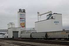
Chelsea Milling, maker of Jiffy Mix, is based in Chelsea. Other employers include Saint Joseph Mercy Chelsea, the Chrysler Proving Grounds, and the Special Alternative Incarceration Facility.[11]
Awards
In 2008, Chelsea District Library was named Best Small Library in America[12] by Library Journal.[13]
Notable people
- Lynn Allen, NFL player
- Dwight E. Beach, U.S. Army general and namesake of Beach Middle School[14]
- Jeff Daniels, actor of stage and screen. Founded the Purple Rose Theatre Company in Chelsea.[15]
- Laura Kasischke, National Book Critics Circle Award winner, poet, novelist
- Tony Scheffler, professional football player for the Detroit Lions
References
- "2017 U.S. Gazetteer Files". United States Census Bureau. Retrieved Jan 3, 2019.
- "U.S. Census website". United States Census Bureau. Retrieved 2012-11-25.
- "Population and Housing Unit Estimates". Retrieved May 21, 2020.
- "U.S. Census website". United States Census Bureau. Retrieved 2008-01-31.
- "US Board on Geographic Names". United States Geological Survey. 2007-10-25. Retrieved 2008-01-31.
- "Profile of General Population and Housing Characteristics: 2010 Demographic Profile Data (DP-1): Chelsea city, Michigan". United States Census Bureau. Retrieved July 5, 2012.
- News-Herald. "thenewsherald.com - The Voice of Downriver". Retrieved 1 December 2016.
- "US Gazetteer files 2010". United States Census Bureau. Archived from the original on 2012-01-25. Retrieved 2012-11-25.
- "Chelsea, Michigan Köppen Climate Classification (Weatherbase)". Retrieved 1 December 2016.
- "Census of Population and Housing". Census.gov. Retrieved June 4, 2015.
- Search Results - Chelsea, Michigan - ReferenceUSA Archived 2016-05-18 at the Portuguese Web Archive Current Businesses
- John N. Berry, III (1 February 2008). "Best Small Library in America 2008: Chelsea District Library-A Michigan Model". Library Journal. Retrieved 5 September 2016.
- "Library Journal". Library Journal.
- XVIII Airborne Corps biography Archived August 9, 2007, at the Wayback Machine
- "Jeff Daniels". Retrieved 1 December 2016.
- "Sister Cities Association of Chelsea, Michigan, Inc". Archived from the original on 4 March 2016. Retrieved 1 December 2016.
External links
| Wikivoyage has a travel guide for Chelsea, Michigan. |
Municipalities and communities of Washtenaw County, Michigan, United States | ||
|---|---|---|
| Cities |  Map of Michigan highlighting Washtenaw County | |
| Villages | ||
| Charter townships | ||
| Civil townships | ||
| CDPs | ||
| Other unincorporated communities |
| |
| Ghost towns | ||
| Footnotes | ‡This populated place also has portions in an adjacent county or counties | |