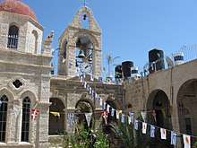
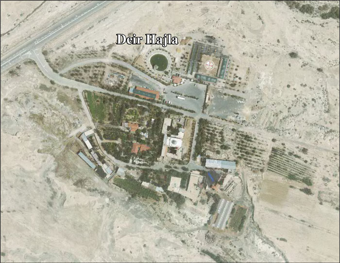
Deir Hajla
Deir Hajla is a Greek Orthodox monastery on the West Bank, north of the Dead Sea.
| Deir Hajla Monastery | |
|---|---|
 Deir Hajla Monastery | |
| Religion | |
| Affiliation | Greek Orthodox Church |
| Location | |
| Location | Jericho Governorate, West Bank |
| Palestine grid | 1976/1365 |
| Geographic coordinates | 31°49′13″N 35°30′07″E |

This monastery is sometimes known as Mar Yohanna Hajlah 'St. John of Hajlah' or Kusr Hajlah.
History
Deir Hajla's origins are vague, but it was probably founded in the third quarter of the fifth century and was first named "Kalamon", after the reeds which grew in the nearby spring. The Monastery of Kalamon existed almost continuously until the 12th century. Early in that century the monastery is described as having walls and being inhabited by around 20 monks.[1]
It was restored in the 12th century, under Patriarch John IX.[1]
An inscription at Madrasa al-Dawadariyya (com.) in Jerusalem, dated to 1295 CE, gives the income from Deir Hajla to this Madrasa.[2][3]
In the fourteenth century the place is called Bet Agla by Marino Sanuto,[4] while it was known to the Latins as the monastery of St. Jerome as early as the fifteenth century.[5]
Ottoman era
In the sixteenth century it was inhabited by monks of the Order of St. Basil.[5]
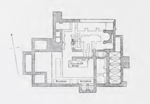
The PEF's Survey of Western Palestine (SWP) visited Kusr Hajlah[7] in 1873 and 1875, and described it: "An important ruin of a mediaeval monastery. The ruin included a large chapel, a second smaller to the south, and a third in the vaults below. The whole is surrounded by a wall, which remains almost perfect on three sides, but is destroyed on the north. The total measure north and south is 125 feet, and east and west 163 feet. There is a projecting tower on the south and west walls, and smaller towers on the north and east. The tower on the south projects 9 feet, and was 17 feet wide; that on the west is 14 feet by 35 feet.
Chapel.—The principal chapel has a bearing 99° west. It has an apse with a domed roof on the east, the diameter 12 feet 10 inches, the depth from the chord 8 feet to the back of the curve. On the south side were remains of a staircase leading to the walls above the apse. The second or smaller chapel was more perfect, having a sort of tower or octagonal lantern over the body of the building, supported by groined vaulting forming pendentives, the arches springing from the corners of the building. The chapel measured 9 feet 6 inches across by 14 feet long, interior measure ; it had a door 2 feet 5 inches wide on the west, a window 2 feet 8 inches wide on the north, two windows 2 feet broad on the south. On the east was the apse, equal in breadth to the chapel, but having two little apses within it, the northern 5 feet 2 inches diameter, 3 feet deep, the southern 2 feet 5 inches in diameter, and 1 foot 10 inches deep. The total height of the chapel was 16 feet ; the lantern above on the interior was a circle 9 feet diameter with four windows ; it was 6 feet high to the cornice, making a total 22 feet from the floor. There is a vault 10 feet deep below the chapel.
The main chapel would appear to have had a nave 44 feet long, 14 feet 6 inches broad in clear, and a side aisle on south without an apse, 8 1/2 feet broad in clear, divided off by piers or pillars now destroyed. The arches, judging from the interior piers on the south wall, which show three bays, had a span of 12 feet. A doorway in the central bay of the south wall led to a vestibule west of the smaller chapel, 9 feet 6 inches broad, and 1 7 feet 9 inches long, interior measure. It seems that a corridor measuring 16 feet broad east and west ran behind both chapels on the west, from which they were entered. The northern outer wall of the monastery is traceable near the north-west corner, and shows that there was a northern aisle to the main chapel 12 feet wide.
South of the smaller chapel there is a large cistern or birkeh, which must have formed the principal water supply of the monastery. It measures 30 feet by 10 feet, and is 24 feet deep.
These buildings are supported on vaults at a lower level, as shown in the plan, the birkeh being sunk yet lower than the vaults. The vaults, entered from beneath the southern chapel, include a small chapel, the apse of which, with a cross rudely painted, was beneath the nave of the larger chapel. The kitchens appear to have been near the south wall of the monastery, remains of cooking places being still visible in 1874. The interior walls of both chapels were painted in fresco, and there appear, as at Deir el Kelt, to be two periods. The floors of both chapels appear to have been covered with marble mosaic."[8]
In April 1882, C. R. Conder revisited the site, finding that "the Greek monks from Mar Saba were engaged in building a new monastery on the spot, and had deliberately scraped off all the frescoes."[9]
References
- Pringle, 1993, p. 197
- van Berchem, 1922, p. 215, note 5
- Burgoyne, 1987, p. 155
- Robinson and Smith, 1841, vol. 2. p. 270
- Robinson and Smith, 1841, vol. 2. p. 271
- Conder and Kitchener, 1883, SWP III, p. 214
- Meaning "The tower of the partridge", according to Palmer, 1881, p. 346
- Conder and Kitchener, 1883, SWP III, pp. 213-215
- Conder and Kitchener, 1883, SWP III, p. 217
Bibliography
- Berchem, van, M. (1922). MIFAO 43 Matériaux pour un Corpus Inscriptionum Arabicarum Part 2 Syrie du Sud T.1 Jérusalem "Ville" (in French and Arabic). Cairo: Impr. de l'Institut français d'archéologie orientale.
- Burgoyne, Michael Hamilton (1987). Mamluk Jerusalem. ISBN 090503533X.
- Conder, C.R.; Kitchener, H.H. (1883). The Survey of Western Palestine: Memoirs of the Topography, Orography, Hydrography, and Archaeology. 3. London: Committee of the Palestine Exploration Fund. (p. 178)
- Dauphin, Claudine (1998). La Palestine byzantine, Peuplement et Populations. BAR International Series 726 (in French). III : Catalogue. Oxford: Archeopress. ISBN 0-860549-05-4. (p. 897)
- Guérin, V. (1874). Description Géographique Historique et Archéologique de la Palestine (in French). 2: Samarie, pt. 1. Paris: L'Imprimerie Nationale. (p. 52ff)
- Maundrell, H. (1703). A Journey from Aleppo to Jerusalem: At Easter, A. D. 1697. Oxford: Printed at the Theatre. (p. 84)
- Palmer, E. H. (1881). The Survey of Western Palestine: Arabic and English Name Lists Collected During the Survey by Lieutenants Conder and Kitchener, R. E. Transliterated and Explained by E.H. Palmer. Committee of the Palestine Exploration Fund.
- Pringle, Denys (1993). The Churches of the Crusader Kingdom of Jerusalem: A-K (excluding Acre and Jerusalem). I. Cambridge University Press. ISBN 0 521 39036 2.
- Robinson, E.; Smith, E. (1841). Biblical Researches in Palestine, Mount Sinai and Arabia Petraea: A Journal of Travels in the year 1838. 2. Boston: Crocker & Brewster.
- Sharon, M. (2004). Corpus Inscriptionum Arabicarum Palaestinae, D-F. 3. BRILL. ISBN 90-04-13197-3. (pp. 48 -54)
- Tristram, H.B. (1865). Land of Israel, A Journal of travel in Palestine, undertaken with special reference to its physical character. London: Society for Promoting Christian Knowledge. (p. 221)
External links
- Monastery of St Gerasimus, seetheholyland.net
- Survey of Western Palestine, Map 18: IAA, Wikimedia commons
- Deir Hajla Locality Profile Applied Research Institute–Jerusalem (ARIJ)
- Deir Hajla arial photo, ARIJ
Religious sites under the Palestinian Authority | ||
|---|---|---|
| Jenin Governorate | Flag of Palestine | |
| Nablus Governorate | ||
| Salfit Governorate |
| |
| Jerusalem Governorate |
| |
| Bethlehem Governorate | ||
| Jericho Governorate | ||
| Hebron Governorate | ||
| Gaza Governorate |
| |
† Access to the site is controlled by Israel. | ||
| Cities |  | |
|---|---|---|
| Municipalities | ||
| Villages |
| |
| Refugee camps | ||
| Other | ||