Al-Auja, Jericho
Al-Auja (Arabic: العوجا) is a Palestinian town in the Jericho Governorate in the eastern West Bank, located ten kilometers north of Jericho. The town has a total area of 107,905 dunams, however its built-up area comprises only 832 dunams. It is situated 230 meters below sea level.
al-Auja | |
|---|---|
Municipality type C | |
| Arabic transcription(s) | |
| • Arabic | العوجا |
| • Latin | al-'Auja (official) al-Awja (unofficial) |
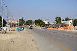 Southern entrance to al-Auja, 2011 | |
 al-Auja Location of al-Auja within Palestine | |
| Coordinates: 31°56′51″N 35°27′42″E | |
| Palestine grid | 195/150 |
| State | State of Palestine |
| Governorate | jr |
| Government | |
| • Type | Municipality (from 1994) |
| Area | |
| • Total | 107,905 dunams (107.9 km2 or 41.7 sq mi) |
| Population (2006) | |
| • Total | 4,000 |
| • Density | 37/km2 (96/sq mi) |
Agricultural land makes up over 10% of the town's area,[1] mostly planted with bananas, oranges, and vegetables for which al-Auja is well known. Irrigation water is mainly supplied from the al-Auja spring.[2]
History
The town is built along, and shares the name of, the Wadi al-Auja stream, "al-auja" meaning "the meandering one". This should not to be confused with the other river called in Arabic by the same name, Nahr al-Auja, and known by its biblical and Hebrew name as the Yarkon River. During World War I this coincidence led to the term of "the line of the two Aujas" referring to a strategic line connecting the two river valleys.[3]
British Mandate era
In the 1922 census of Palestine conducted by the British Mandate authorities, Al-Auja, together with ad-Duyuk and Nweimeh had a population of 332; 322 Muslims and 10 Christians,[4] where the Christians were 7 Orthodox, and 3 Syrian Catholic.[5] According to the 1931 census, Al-Auja had a population of 253 Muslims, in 100 houses.[6]
In the 1945 statistics, the village's population was 290, while Arab el Nuseirat had 520, Arab el Kaabina had 260, Arab el Ureinat had 210 and Arab el Saayida had 110 members; a total of 1,390; all Muslims,[7] and together they had jurisdiction over 106,946 dunams of land.[8] Of this, 418 dunams were used for citrus and bananas, 2,822 dunams were for plantations and irrigable land, 6,502 for cereals,[9] while a total of 97,204 dunams were classified as non-cultivable areas.[10]
Jordanian era
In the wake of the 1948 Arab–Israeli War, and after the 1949 Armistice Agreements, al-Auja came under Jordanian rule. It was annexed by Jordan in 1950.
Post 1967
Since the 1967 Six-Day War, al-Auja has been under Israeli occupation. 30,147 dunams of al-Auja's land was classified as "closed-off area" barred from Palestinian use.[1]
According to ARIJ, Israel have confiscated land from Al-Auja in order to construct four Israeli settlements:
- 993 dunams for Nativ HaGdud,[11]
- 499 dunams for Yitav.[11]
- 497 dunams for Niran,[11]
- 268 dunams for Gilgal.[11]
According to the Palestinian Central Bureau of Statistics, al-Auja had a population of over 4,000 inhabitants in mid-year 2006.[12] In 1997, refugees constituted 24.7% of the population.[13] The 15.5% of Al-Auja area which is located in "Area A", was transferred to the Palestinian National Authority in a 1994 deal which also included Jericho and Gaza. The remaining 84.5% of al-Auja is Area C, which remains under total Israeli control.[1]
References
- Al 'Auja village Archived 2007-08-14 at the Wayback Machine Applied Research Institute - Jerusalem. 21 January 2006.
- Welcome to al-'Auja Palestine Remembered.
- H. S. Gullett (1923). The Australian Imperial Force in Sinai and Palestine, 1914-1918 (PDF). Sydney: Angus & Robertson Ltd. p. 487. Archived from the original (PDF) on 3 November 2013. Retrieved 16 September 2015.
Allenby did not hesitate. His original objective had been the "line of the two Aujas" from the Nahr Auja, which falls into the Mediterranean above Jaffa, to the Wady Auja, a little stream which, bursting from springs in the desert foot-hills above the Jordan valley, flows eastwards to the Jordan River about ten miles north of the Dead Sea.
- Barron, 1923, Table VII, Sub-district of Jericho, p. 19
- Barron, 1923, Table XIV, p. 45
- Mills, 1932, p. 45
- Government of Palestine, Department of Statistics, 1945, p. 24
- Government of Palestine, Department of Statistics. Village Statistics, April, 1945. Quoted in Hadawi, 1970, p. 56 Archived 2008-08-05 at the Library of Congress Web Archives
- Government of Palestine, Department of Statistics. Village Statistics, April, 1945. Quoted in Hadawi, 1970, p. 101 Archived 2018-06-22 at the Wayback Machine
- Government of Palestine, Department of Statistics. Village Statistics, April, 1945. Quoted in Hadawi, 1970, p. 151 Archived 2018-06-22 at the Wayback Machine
- Al 'Auja Town Profile p. 19
- Projected Mid -Year Population for Jericho District by Locality 2004- 2006 Palestinian Central Bureau of Statistics
- Palestinian Population by Locality and Refugee Status Archived 2008-11-18 at the Wayback Machine (1997) Palestinian Central Bureau of Statistics.
Bibliography
- Barron, J.B., ed. (1923). Palestine: Report and General Abstracts of the Census of 1922. Government of Palestine.
- Government of Palestine, Department of Statistics (1945). Village Statistics, April, 1945.
- Hadawi, S. (1970). "Village Statistics of 1945: A Classification of Land and Area ownership in Palestine". Palestine Liberation Organization Research Center. Archived from the original on 2018-12-08. Retrieved 2015-02-14. Cite journal requires
|journal=(help) - Mills, E., ed. (1932). Census of Palestine 1931. Population of Villages, Towns and Administrative Areas. Jerusalem: Government of Palestine.
External links
- Welcome To al-'Auja
- Survey of Western Palestine, Map 15: IAA, Wikimedia commons
- Al 'Auja Town (Fact Sheet), Applied Research Institute–Jerusalem (ARIJ)
- Al 'Auja Town Profile (ARIJ)
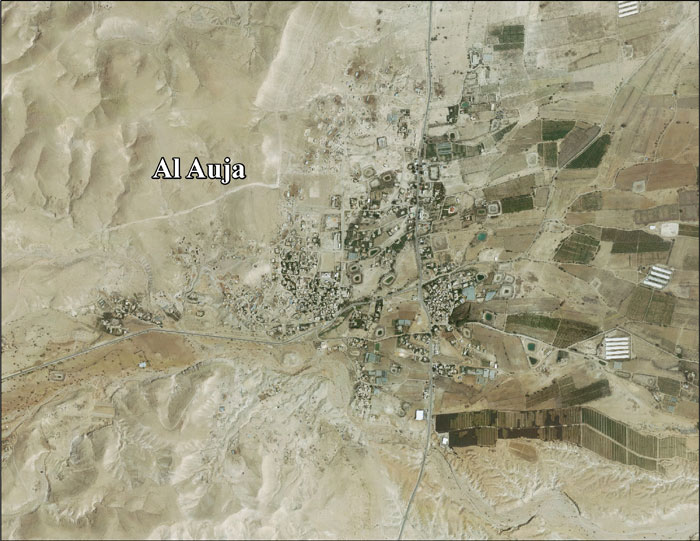
- Al 'Auja aerial photo (ARIJ)
- Locality Development Priorities and Needs in Al 'Auja (ARIJ)
| Cities |  | |
|---|---|---|
| Municipalities | ||
| Villages |
| |
| Refugee camps | ||
| Other | ||