Nabi Yahya Mosque
The Nabi Yahya Mosque (Arabic: جامع النبي يحيى, Jama'a Nabi Yahya, meaning "mosque of the Prophet John") is a mosque containing the traditional Tomb of John the Baptist as well as the Tomb of Elisha and the Tomb of Obadiah.
| Nabi Yahya Mosque | |
|---|---|
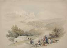
 The mosque circa 1920 | |
| Religion | |
| Affiliation | Islam |
| District | Nablus Governorate |
| Province | West Bank |
| Status | Active |
| Location | |
| Location | Sebastia, Palestine |
| Geographic coordinates | 32.276715°N 35.196°E |
| Architecture | |
| Style | Ayyubid/Mamluk |
| Completed | 1261 |
| Specifications | |
| Dome(s) | 1 |
| Minaret(s) | 1 |
| Minaret height | 30 meters (98 ft) |
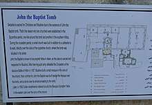
It is the main mosque in the village of Sebastia, near Nablus. It is located in the central square of the village. It is constructed of large buttressed walls. Within its courtyard, a stairway in the small domed building leads down into a cave.
The Umayyad Mosque in Damascus also claims to hold John's body.
History
Byzantine church
The Nabi Yahya Mosque stands on the site identified since Byzantine times as the place where John the Baptist's body was buried by his followers. Matthew 14:12 records that "his disciples came and took away [John's] body and buried it". A church was erected on the spot of the tomb during the Byzantine era.
Crusader cathedral
This was superseded by a Crusader-built church in 1160.[1] It was transformed into a mosque by Saladin in 1187, although some sources say it was converted by the Mamluks in 1261. Nabi Yahya refers to John the Baptist in the Arabic language.
In 1870, the French explorer Victor Guérin visited the place, and noted: "At the western extremity of the monument rises a Musulman sanctuary crowned by a little cupola pierced with narrow windows, which admit a feeble light into the crypt which it covers. This crypt probably belongs to the ancient basilica, which was replaced by the edifice now itself in ruins. Descent is managed by a staircase of fifteen steps ; then, after crossing a landing once closed by a monolithic door, you go down two steps, and find yourself in a crypt formerly paved with small slabs of marble in different colours, forming a sort of mosaic. Here lies the door of which I have just spoken: mouldings divide it into compartments; it is provided with hinges worked in the thickness of the block which composes the stone. This crypt, of small extent, contains a sepulchral chamber divided into three parallel arched loculi, with cut stones regularly worked between them. They are only seen by introducing a light across three small openings in the wall of the chamber. According to an ancient tradition, one of these compartments is the tomb of St. John the Baptist, and the others those of the prophets Obadiah and Elisha."[2] Later, in the 1870s, Palestine Exploration Fund excavated the place, which it described in its Survey of Western Palestine as "a mere shell, the greater part of the roof and aisle piers gone, and over the crypt a modern kubbeh has been built. The interior length is 158 feet, the breadth 74 feet; the west wall is 10 feet thick, the north wall 8 feet, the south wall 4 feet. There were six bays, of which the second from the east is larger, probably once supporting a dome. On the east are three apses to nave and aisles, the central apse is 30 feet in diameter, equal to the width of the nave. The piers had four columns attached, one each side; on the west was a doorway and two windows; on the south four windows remain, and on the north three."[3]
Ottoman rebuilding
In 1892, Abdul Hamid II ordered the rebuilding of part of the site. The mosque was restored and mostly rebuilt during the 19th century while Palestine was under Ottoman rule.[1]
Prison of John the Baptist
Local tradition in both the Christian and Muslim communities of the area notes that Sebastia also contained the site of the prison of John the Baptist and is the place where he was beheaded; however this was a separate church in the old city and is a claim refuted by the account of the first century historian Josephus, which recorded the site of the beheading as Machaerus, across the Jordan, some 80-90 miles away.[4]
References
- Jacobs, 1998, p.443.
- Guérin, 1875, pp. 189; as translated by Conder and Kitchener, 1882, SWP II, pp. 213-214
- Conder and Kitchener, 1882, SWP II, pp.212-213
- Estimate using Google Maps, 17 January 2017
Bibliography
- Conder, C.R.; Kitchener, H.H. (1882). The Survey of Western Palestine: Memoirs of the Topography, Orography, Hydrography, and Archaeology. 2. London: Committee of the Palestine Exploration Fund.
- Guérin, V. (1875). Description Géographique Historique et Archéologique de la Palestine (in French). 2: Samarie, pt. 2. Paris: L'Imprimerie Nationale.
- Jacobs, Daniel (1998). Israel and the Palestinian territories. Rough Guides. ISBN 978-1-85828-248-0.
| West Bank |
| |
|---|---|---|
| Gaza Strip | ||
| East Jerusalem | Note: East Jerusalem is under de facto Israeli control, though claimed by Palestinians | |
| ||