Dąbrowa Górnicza
Dąbrowa Górnicza [dɔmˈbrɔva ɡurˈɲit͡ʂa] (![]()
Dąbrowa Górnicza | |
|---|---|
98.jpg) Palace of Culture | |
 Flag  Coat of arms | |
 Dąbrowa Górnicza  Dąbrowa Górnicza | |
| Coordinates: 50°19′17″N 19°11′14″E | |
| Country | |
| Voivodeship | |
| County | city county |
| Town rights | 1916 |
| Government | |
| • Mayor | Marcin Bazylak |
| Area | |
| • City | 188 km2 (73 sq mi) |
| Population (31 December 2018) | |
| • City | 120,259 |
| • Urban | 2,746,000 |
| • Metro | 4,620,624 |
| Time zone | UTC+1 (CET) |
| • Summer (DST) | UTC+2 (CEST) |
| Postal code | 41–300 to 42–530 |
| Area code(s) | +48 32 |
| Car plates | SD |
| Website | http://www.dabrowa-gornicza.pl/ |
Even though Dąbrowa Górnicza belongs to the historic province of Lesser Poland, it now is situated in the Silesian Voivodeship (since 1999), and previously (1975–1999) it was in Katowice Voivodeship. Dąbrowa Górnicza is one of the cities of the 2.7 million conurbation – Katowice urban area, and within a greater silesian metropolitan area populated by about 5.2 million people.[2] The population of the city itself is 120,259 (Dec 2018).[1]
Area and districts
Dąbrowa Górnicza is the largest city of the province and the 9th largest in Poland in terms of territory, with total area of 188 square kilometers. The city lies among the hills, at 258 to 390 meters above sea level. Dąbrowa Górnicza borders Będzin County, Zawiercie County, Olkusz County and the city of Sosnowiec. The city is divided into several districts: Antoniów, Błędów, Bugaj, Centrum, Dziewiąty, Gołonóg, Korzeniec, Kuźniczka Nowa, Łazy Błędowskie, Łęka, Łęknice, Łosień, Marianki, Mydlice, Okradzionów, Piekło, Ratanice, Reden, Sikorka, Strzemieszyce Małe, Strzemieszyce Wielkie, Trzebiesławice, Trzydziesty, Tucznawa, Ujejsce, Ząbkowice. Furthermore, in 1977–1984 the town of Sławków was a district of Dąbrowa Górnicza.
The place name Dąbrowa, is derived from the Polish word dąb (oak), and denotes an oak grove, as the territory of the original village is believed to have been covered by oak forests back in the early days of its existence. From the 19th century, the settlement grew to be an important coal mining center, and its name was supplemented by the adjective Górnicza (which refers to mining) in 1919, to distinguish it from such towns, as Dąbrowa Tarnowska and Dąbrowa Białostocka.

History
In the first half of the 18th century Dąbrowa was a small agricultural settlement belonging to the Będzin parish of Lesser Poland's Kraków Voivodeship. First mentioned on 25 July 1726, when parish priest of Holy Trinity Church at Będzin noted a woman named Anna Lisowa from Dąbrowa. According to the 1787 census of the Archdiocese of Kraków, the settlement numbered 184 inhabitants. The districts of Dąbrowa, which for centuries had been separate villages, are much older. Trzebieslawice was first mentioned in the 12th century, Błędow was mentioned by Bishop of Kraków Iwo Odrowąż in the year 1220, Strzemieszyce and Ujejsce were mentioned in the 14th century, Gołonóg in the 15th century, while Ząbkowice was described by Jan Długosz.

After the Third Partition of Poland (1795) Dąbrowa was incorporated into the Prussian province of New Silesia. The Prussians discovered rich deposits of coal here and the first coal mine was established by Friedrich Wilhelm von Reden in 1796. In 1799, first detailed map of this area was created, on which a settlement called Stara Dąbrowa is presented. It was located along a road from Kraków to Upper Silesia. The coal mine, established by Friedrich Reden, attracted workers, and a settlement was soon established around it. In 1815, Dąbrowa was annexed by Russian-controlled Congress Poland. In 1846, the Cieszkowski Coal Mine was opened, named after Józef Cieszkowski. The Zinc Plant Konstanty operated as early as 1823, and the Huta Bankowa steel works, which is still in operation, was built in Dąbrowa Górnicza in 1834. First primary school was opened in 1820, and first Roman Catholic church of St. Alexander was built in the 1870s. In 1909 the gmina of Dąbrowa Górnicza was established by Tsarist authorities. Even though its population reached 30,000, the Russians were reluctant to grant Dąbrowa town charter, so it remained a village until 18 August 1916, when Austrian authorities, which during World War I occupied southern part of Congress Poland, agreed to establish the town. In the Second Polish Republic, Dąbrowa belonged to Kielce Voivodeship, and during World War II it was annexed into the Third Reich, as part of the Upper Silesia Province. Together with whole Zagłębie Dąbrowskie, the city was transferred to Katowice Voivodeship after World War II, in 1945.
The 1970s saw the construction of the Katowice Steelworks, which is nowadays the biggest steel producing plant in Poland, after privatization owned by ArcelorMittal. In the 1970s the town expanded territorially and economically. In 1975 and 1977 the neighboring localities of Strzemieszyce Małe, Strzemieszyce Wielkie, Ząbkowice and others became suburbanized. The population of Dąbrowa Górnicza reached its peak in 1982 with 152,373 inhabitants. In the 1990s all local coal mines were closed, because of lack of coal. But the oldest part of the town Reden still exists.
.jpg)
Education
- Silesian Technical University, Faculty of Chemistry, Industrial and Environmental Chemistry course
- Wyższa Szkoła Biznesu
- Wyższa Szkoła Planowania Strategicznego
Transport
There are many important routes crossing in Dąbrowa Górnicza. These include expressway S1 and national road 94. Expressway S1 is a direct connection to motorway A4 and to Katowice International Airport.
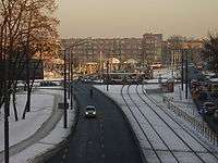
Also Dąbrowa Górnicza has rich railway network access including Warsaw-Katowice line (VI Pan-European corridor) and nearby Broad Gauge Metallurgy Line terminal in Sławków. The rail network is very dense in the city as it is a branching point of former Warsaw-Vienna railway. There are nine rail stations within city limits: Dąbrowa Górnicza, Dąbrowa Górnicza Pogoria, Dąbrowa Górnicza Gołonóg, Dąbrowa Górnicza Ząbkowice, Dąbrowa Górnicza Sikorka, Dąbrowa Górnicza Strzemieszyce, Dąbrowa Górnicza Wschodnia, Dąbrowa Górnicza Huta Katowice, and Dąbrowa Górnicza Południowa. Express and fast trains stop at two stations: Dąbrowa Górnicza and Dąbrowa Górnicza Ząbkowice, all other stations serve local connections.
There is also a tram network, being part of Silesian Interurbans.
Nature

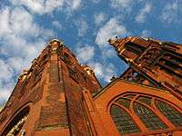
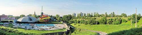
In Dąbrowa there are many green areas. Total area of local lakes is over 800 hectares, there are 180 hectares of parks (0.96%) and 4100 hectares of forests (21.7%). Particularly noteworthy is the complex of Pogoria (lakes). Also, the largest Polish desert, Błędów Desert, lies within city limits. Furthermore, part of the Eagles' Nests Landscape Park reaches the outskirts of the city. Among cultural institutions there are the Palace of Zagłębie Culture, City Museum Sztygarka, Ząbkowice House of Culture, Zagłębie Music Scene, Chamber Orchestra of Zagłębie, Film Center Helios, Music and Arts Schools.
Notable people
- Karol Adamiecki (1866–1933), economist, engineer
- Aleksander Zawadzki (1899–1964), head of state of Poland in 1952–1964
- Jerzy Pławczyk (1911–1989), athlete, competed at 1932 and 1936 Summer Olympics
- Edward Babiuch (b. 1927), communist political figure
- Zdzisław Marchwicki (1927–1977), serial killer
- Kazimierz Imieliński (1929–2010), physician and father of Polish sexology
- Sobiesław Zasada (b. 1930), rally driver, businessman
- Janusz Gajos (b. 1939), actor
- Jerzy Janikowski (1952–2006), Olympic fencer
- Dawid Podsiadło (b. 1992), singer
Twin towns – sister cities
Dąbrowa Górnicza is twinned with:[3]


References
- "Local Data Bank". Statistics Poland. Retrieved 2 June 2019. Data for territorial unit 2465000.
- European Spatial Planning Observation Network (ESPON)"Archived copy". Archived from the original on 28 July 2009. Retrieved 28 March 2009.CS1 maint: archived copy as title (link)
- "Miasta partnerskie". dabrowa-gornicza.pl (in Polish). Dąbrowa Górnicza. Retrieved 10 March 2020.
External links
| Wikimedia Commons has media related to Dąbrowa Górnicza. |
- Encyclopædia Britannica Dąbrowa Górnicza
- Jewish Community in Dąbrowa Górnicza on Virtual Shtetl
- Jewish family of Dabrowa Ghetto
- Dąbrowa Górnicza page for investors
- Forum about Dąbrowa Górnicza
- The City of Dąbrowa Górnicza
- The Dabrowa-Gornicza Ghetto part 1 Nazi movie
- The Dabrowa-Gornicza Ghetto part 2 Nazi movie
- www.dawnadabrowa.pl – history of the town
- "Here Their Stories Will Be Told..." The Valley of the Communities at Yad Vashem, Dąbrowa Górnicza, at Yad Vashem website.
| |||||||||||||||||||||||

| Authority control |
|
|---|