Conway (CDP), New Hampshire
Conway is a census-designated place (CDP) in the town of Conway in Carroll County, New Hampshire, United States. The population was 1,823 at the 2010 census,[1] making it the second-largest settlement in the town of Conway, after the village of North Conway.
Conway, New Hampshire | |
|---|---|
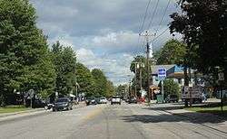 Conway on NH 16 | |
 Conway  Conway | |
| Coordinates: 43°58′44″N 71°7′36″W | |
| Country | United States |
| State | New Hampshire |
| County | Carroll |
| Town | Conway |
| Area | |
| • Total | 3.1 sq mi (7.9 km2) |
| • Land | 2.9 sq mi (7.4 km2) |
| • Water | 0.2 sq mi (0.5 km2) |
| Elevation | 459 ft (140 m) |
| Population (2010) | |
| • Total | 1,823 |
| • Density | 642/sq mi (247.9/km2) |
| Time zone | UTC-5 (Eastern (EST)) |
| • Summer (DST) | UTC-4 (EDT) |
| ZIP code | 03818 |
| Area code(s) | 603 |
| FIPS code | 33-14580 |
| GNIS feature ID | 0871721 |
Geography
According to the United States Census Bureau, the CDP has a total area of 3.1 square miles (7.9 km2). 2.9 square miles (7.4 km2) of it is land and 0.19 square miles (0.5 km2), or 6.81%, is water.[1]
The village lies in the southwestern part of the town of Conway, situated at the juncture of the Saco River, the Swift River, and Pequawket Brook. New Hampshire Route 16, Route 113, and Route 153 converge at the village center.
Demographics
As of the census of 2010, there were 1,823 people, 853 households, and 441 families residing in the CDP. The population density was 628.6 people per square mile (247.9/km2). There were 1,062 housing units, of which 209, or 19.7%, were vacant. 147 of the vacant units were seasonal or vacation properties. The racial makeup of the town was 97.4% White, 0.1% African American, 0.7% Native American, 0.4% Asian, 0.2% some other race, and 1.2% from two or more races. 0.4% of the population were Hispanic or Latino of any race.[2]
There were 853 households, out of which 25.4% had children under the age of 18 living with them, 34.3% were headed by married couples living together, 12.4% had a female householder with no husband present, and 48.3% were non-families. 38.6% of all households were made up of individuals, and 13.6% were someone living alone who was 65 years of age or older. The average household size was 2.14, and the average family size was 2.85.[2]
In the CDP, the population was spread out, with 20.6% under the age of 18, 8.1% from 18 to 24, 25.8% from 25 to 44, 30.2% from 45 to 64, and 15.4% who were 65 years of age or older. The median age was 42.6 years. For every 100 females, there were 93.1 males. For every 100 females age 18 and over, there were 88.8 males.[2]
For the period 2007-11, the estimated median annual income for a household was $34,250, and the median income for a family was $60,135. Male full-time workers had a median income of $42,303 versus $26,635 for females. The per capita income for the CDP was $24,752. 18.6% of the population and 7.9% of families were below the poverty line.[3]
References
- "Geographic Identifiers: 2010 Demographic Profile Data (G001): Conway CDP, New Hampshire". U.S. Census Bureau, American Factfinder. Archived from the original on February 12, 2020. Retrieved April 3, 2013.
- "Profile of General Population and Housing Characteristics: 2010 Demographic Profile Data (DP-1): Conway CDP, New Hampshire". U.S. Census Bureau, American Factfinder. Archived from the original on February 12, 2020. Retrieved April 3, 2013.
- "Selected Economic Characteristics: 2007-2011 American Community Survey 5-Year Estimates (DP03): Conway CDP, New Hampshire". U.S. Census Bureau, American Factfinder. Archived from the original on February 10, 2020. Retrieved April 3, 2013.
Municipalities and communities of Carroll County, New Hampshire, United States | ||
|---|---|---|
| Towns | 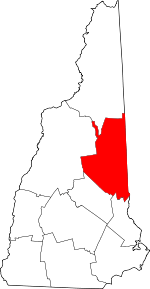 Map of New Hampshire highlighting Carroll County | |
| Township | ||
| CDPs | ||
| Other villages | ||