Bartlett, New Hampshire
Bartlett is a town in Carroll County, New Hampshire, United States. The population was 2,788 at the 2010 census.[1] Bartlett includes the unincorporated community of Glen as well as portions of the communities of Kearsarge and Intervale which the town shares with the neighboring town of Conway. It is set in the White Mountains and is surrounded by the White Mountain National Forest. It is home to the Attitash Mountain Resort and the Story Land theme park.
Bartlett, New Hampshire | |
|---|---|
Town | |
 Bartlett Elementary School and Library | |
| Motto(s): "In the Heart of the White Mountains" | |
 Location in Carroll County, New Hampshire | |
| Coordinates: 44°04′40″N 71°16′58″W | |
| Country | United States |
| State | New Hampshire |
| County | Carroll |
| Incorporated | 1790 |
| Villages | Bartlett Glen Intervale Lower Bartlett |
| Government | |
| • Board of Selectmen | Gene G. Chandler David A. Patch Vicki L. Garland |
| Area | |
| • Total | 75.3 sq mi (195.0 km2) |
| • Land | 74.9 sq mi (193.9 km2) |
| • Water | 0.4 sq mi (1.1 km2) 0.57% |
| Elevation | 671 ft (205 m) |
| Population (2010) | |
| • Total | 2,788 |
| • Density | 37/sq mi (14/km2) |
| Time zone | UTC-5 (Eastern) |
| • Summer (DST) | UTC-4 (Eastern) |
| ZIP codes | |
| Area code(s) | 603 |
| FIPS code | 33-03700 |
| GNIS feature ID | 0873539 |
| Website | www |
The main village in town, where 373 people resided at the 2010 census, is defined by the U.S. Census Bureau as the Bartlett census-designated place and is located at the intersection of U.S. Route 302 with Bear Notch Road (Albany Avenue).
History

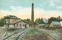
Settled after 1769 and incorporated in 1790, the town is named for Dr. Josiah Bartlett, the first chief executive to bear the name "governor", a representative to the Continental Congress, and one of New Hampshire's three signers of the Declaration of Independence. Dr. Bartlett founded the New Hampshire Medical Society in 1791. Bartlett became a railroad town in 1875 when the Maine Central Railroad's Mountain Division was built. In 1954, Story Land, a theme park designed for young children, opened in Glen. Attitash ski area opened in the 1960s.
The Bartlett Roundhouse in Bartlett village was listed on the National Register of Historic Places in September 2015.[2]
Tourism
Bartlett's views of the White Mountains have long made tourism a principal business. The town has one covered bridge. Attitash ski area is the second largest ski area in New Hampshire. Bartlett also is home to the Bear Notch Ski Touring area affording Nordic ski enthusiasts trails in the upper Saco River Valley. Bartlett is also an attraction for railfans. The Conway Scenic Railroad, a heritage railway in nearby North Conway, operates a train to the town daily for sightseeing in the spring, summer, and fall.
Geography
According to the United States Census Bureau, the town has a total area of 75.3 square miles (195 km2), of which 74.9 square miles (194 km2) is land and 0.4 square miles (1.0 km2), or 0.57%, is water.[3] Bartlett is drained by the Saco and Ellis rivers. The highest point in Bartlett is Mount Tremont, elevation 3,371 feet (1,027 m) above sea level. Mount Parker, elevation 3,004 ft (916 m), is in the north, and Bear Mountain, elevation 3,200 ft (980 m), is on the southern boundary. Bartlett lies fully within the Saco River watershed.[4]
In addition to the town center, Bartlett includes the following villages within its limits:
- Glen, which is the home to the Story Land amusement park
- Intervale, a resort community
- Lower Bartlett, between Glen and Intervale, along the East Branch Saco River
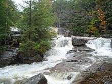
Goodrich Falls on the Ellis River is in the northern part of the town, next to NH 16.
Demographics
| Historical population | |||
|---|---|---|---|
| Census | Pop. | %± | |
| 1850 | 761 | — | |
| 1860 | 735 | −3.4% | |
| 1870 | 629 | −14.4% | |
| 1880 | 1,044 | 66.0% | |
| 1890 | 1,247 | 19.4% | |
| 1900 | 1,013 | −18.8% | |
| 1910 | 1,197 | 18.2% | |
| 1920 | 1,059 | −11.5% | |
| 1930 | 1,119 | 5.7% | |
| 1940 | 1,154 | 3.1% | |
| 1950 | 1,074 | −6.9% | |
| 1960 | 1,013 | −5.7% | |
| 1970 | 1,098 | 8.4% | |
| 1980 | 1,566 | 42.6% | |
| 1990 | 2,290 | 46.2% | |
| 2000 | 2,705 | 18.1% | |
| 2010 | 2,788 | 3.1% | |
| Est. 2017 | 2,785 | [5] | −0.1% |
| U.S. Decennial Census[6] | |||
As of the census of 2010, there were 2,788 people, 1,307 households, and 762 families residing in the town. There were 4,115 housing units, of which 2,808, or 68.2%, were vacant. 2,691 of the vacant units were for seasonal or recreational use. The racial makeup of the town was 97.7% white, 0.3% African American, 0.3% Native American, 0.4% Asian, 0.0% Native Hawaiian or Pacific Islander, 0.0% some other race, and 1.3% from two or more races. 0.9% of the population were Hispanic or Latino of any race.[7]
Of the 1,307 households, 21.8% had children under the age of 18 living with them, 46.4% were headed by married couples living together, 8.1% had a female householder with no husband present, and 41.7% were non-families. 31.4% of all households were made up of individuals, and 11.3% were someone living alone who was 65 years of age or older. The average household size was 2.13, and the average family size was 2.66.[7]
In the town, 17.4% of the population were under the age of 18, 5.2% were from 18 to 24, 20.7% from 25 to 44, 36.3% from 45 to 64, and 20.5% were 65 years of age or older. The median age was 49.0 years. For every 100 females, there were 99.3 males. For every 100 females age 18 and over, there were 99.2 males.[7]
For the period 2011-2015, the estimated median annual income for a household was $50,536, and the median income for a family was $80,229. The per capita income for the town was $35,700. 10.0% of the population and 5.0% of families were below the poverty line. 8.2% of the population under the age of 18 and 5.7% of those 65 or older were living in poverty.[8]
References
- United States Census Bureau, American FactFinder, 2010 Census figures. Retrieved March 23, 2011.
- "Weekly List of Actions Taken on Properties: 9/28/15 through 10/02/15". National Park Service: National Register of Historic Places. Retrieved Oct 14, 2015.
- "Geographic Identifiers: 2010 Demographic Profile Data (G001) - Bartlett town, New Hampshire". United States Census Bureau. Retrieved November 7, 2011.
- Foster, Debra H.; Batorfalvy, Tatianna N.; Medalie, Laura (1995). Water Use in New Hampshire: An Activities Guide for Teachers. U.S. Department of the Interior and U.S. Geological Survey.
- "Annual Estimates of the Resident Population: April 1, 2010 to July 1, 2017 (PEPANNRES): Minor Civil Divisions – New Hampshire". Archived from the original on February 13, 2020. Retrieved November 14, 2018.
- "Census of Population and Housing". Census.gov. Retrieved June 4, 2016.
- "Profile of General Population and Housing Characteristics: 2010 Census Summary File 1 (DP-1): Bartlett town, Carroll County, New Hampshire". U.S. Census Bureau, American Factfinder. Archived from the original on February 13, 2020. Retrieved October 25, 2017.
- "Selected Economic Characteristics: 2011-2015 American Community Survey 5-Year Estimates (DP03): Bartlett town, Carroll County, New Hampshire". U.S. Census Bureau, American Factfinder. Archived from the original on February 13, 2020. Retrieved October 25, 2017.
External links
| Wikimedia Commons has media related to Bartlett, New Hampshire. |
- Official website
- Bartlett Historical Society
- BartlettNH.net, local information
- New Hampshire Economic and Labor Market Information Bureau Profile
Places adjacent to Bartlett, New Hampshire | |
|---|---|
Municipalities and communities of Carroll County, New Hampshire, United States | ||
|---|---|---|
| Towns | 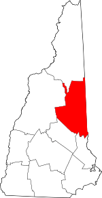 Map of New Hampshire highlighting Carroll County | |
| Township | ||
| CDPs | ||
| Other villages | ||