Chatham, New Hampshire
Chatham is a town in Carroll County, New Hampshire, United States. The population was 337 at the 2010 census.[1] It is located in the White Mountains, and except for the southeast corner, all of Chatham is in the White Mountain National Forest. The town is home to the Cold River national forest campgrounds.
Chatham, New Hampshire | |
|---|---|
Town | |
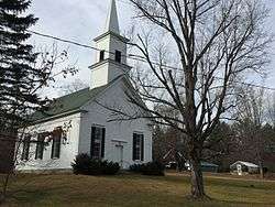 Chatham Congregational Church in Chatham village | |
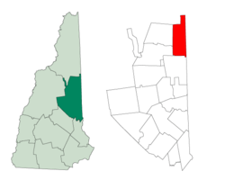 Location in Carroll County, New Hampshire | |
| Coordinates: 44°09′49″N 71°00′40″W | |
| Country | United States |
| State | New Hampshire |
| County | Carroll |
| Incorporated | 1767 |
| Villages | Chatham North Chatham South Chatham |
| Government | |
| • Board of Selectmen | Wayne Infinger, Chair Jason Eastman Micah Voter |
| Area | |
| • Total | 57.2 sq mi (148.2 km2) |
| • Land | 56.7 sq mi (146.9 km2) |
| • Water | 0.5 sq mi (1.3 km2) 0.89% |
| Elevation | 521 ft (159 m) |
| Population (2010) | |
| • Total | 337 |
| • Density | 5.9/sq mi (2.3/km2) |
| Time zone | UTC-5 (Eastern) |
| • Summer (DST) | UTC-4 (Eastern) |
| ZIP code | 03813 |
| Area code(s) | 603 |
| FIPS code | 33-11780 |
| GNIS feature ID | 0873563 |
| Website | chathamnh |
History
Chatham was granted to Peter Livins and others, 7 February 1767,[2] by colonial Governor Benning Wentworth. The town was named in honor of William Pitt, Earl of Chatham and Prime Minister of Great Britain, who had recently led Britain to victory in the Seven Years War. Chatham was regranted in 1770 by his nephew, Governor John Wentworth, to a group including Samuel Langdon, president of Harvard College and creator of the "Blanchard Map" of the North Country. Part of Conway was annexed in 1829.
Geography
According to the United States Census Bureau, the town has a total area of 57.2 square miles (148 km2), of which 56.7 sq mi (147 km2) is land and 0.5 sq mi (1.3 km2) (0.89%) is water. The highest point in Chatham is the summit of South Baldface, with an elevation of 3,547 feet (1,081 m) above sea level. Sable Mountain, elevation 3,519 ft (1,073 m), is in the west, and Robbins Ridge crosses the center of Chatham from east to west. Upper Kimball Pond is in the southeast, and Basin Pond in the northeast. Chatham lies fully within the Saco River watershed.[3]
An article in Statistics and Gazetteer of New-Hampshire (1875) stated,
"Carter's Mountain rises so high between this town and Jackson as to prevent the opening of a highway, and the people of the respective towns, in their intercourse, are obliged to pass through a portion of Maine. Kiarsarge [sic], in the south-west corner of the town, has...upon the summit...a commodious house for the accommodation of visitors. The views from this mountain are grand and very extensive. In the north-west corner is Baldface Mountain. Teams can be driven nearly to its summit. From the crest of this mountain the Tip-Top House on Mount Washington can be seen, also the ocean."[2]
"Kiarsarge" (now Kearsarge North) and Baldface are now accessible only by hiking trails, and the summit of Kearsarge North has a lookout tower but no other structures. The views are still as extensive as before. Access to the town of Jackson continues to be partially through Maine, by taking Maine State Route 113 south to the Fryeburg area, then traveling west through Conway. Route 113, leading north, crosses into New Hampshire in the North Chatham part of town, then curves back into Maine to cross the mountains in Evans Notch and descend north to U.S. Route 2 in Gilead, Maine.
Chatham is a pene-enclave, functionally accessible to neighboring New Hampshire towns only by traveling through Maine first.
Adjacent municipalities
- Bean's Purchase, New Hampshire (north)
- South Oxford, Maine (northeast)
- Stow, Maine (east)
- Fryeburg, Maine (southeast)
- Conway, New Hampshire (south)
- Bartlett, New Hampshire (southwest)
- Jackson, New Hampshire (west)
Demographics
| Historical population | |||
|---|---|---|---|
| Census | Pop. | %± | |
| 1790 | 58 | — | |
| 1800 | 183 | 215.5% | |
| 1810 | 201 | 9.8% | |
| 1820 | 298 | 48.3% | |
| 1830 | 419 | 40.6% | |
| 1840 | 523 | 24.8% | |
| 1850 | 516 | −1.3% | |
| 1860 | 489 | −5.2% | |
| 1870 | 445 | −9.0% | |
| 1880 | 421 | −5.4% | |
| 1890 | 329 | −21.9% | |
| 1900 | 267 | −18.8% | |
| 1910 | 209 | −21.7% | |
| 1920 | 229 | 9.6% | |
| 1930 | 168 | −26.6% | |
| 1940 | 184 | 9.5% | |
| 1950 | 177 | −3.8% | |
| 1960 | 150 | −15.3% | |
| 1970 | 134 | −10.7% | |
| 1980 | 189 | 41.0% | |
| 1990 | 268 | 41.8% | |
| 2000 | 260 | −3.0% | |
| 2010 | 337 | 29.6% | |
| Est. 2017 | 353 | [4] | 4.7% |
| U.S. Decennial Census[5] | |||
As of the census[6] of 2000, there were 260 people, 107 households, and 71 families residing in the town. The population density was 4.6 people per square mile (1.8/km2). There were 253 housing units at an average density of 4.5 per square mile (1.7/km2). The racial makeup of the town was 98.08% White, 1.15% from other races, and 0.77% from two or more races.
There were 107 households, out of which 29.0% had children under the age of 18 living with them, 57.0% were married couples living together, 5.6% had a female householder with no husband present, and 33.6% were non-families. 27.1% of all households were made up of individuals, and 8.4% had someone living alone who was 65 years of age or older. The average household size was 2.43 and the average family size was 2.94.
In the town, the population was spread out, with 24.6% under the age of 18, 4.2% from 18 to 24, 30.0% from 25 to 44, 30.4% from 45 to 64, and 10.8% who were 65 years of age or older. The median age was 41 years. For every 100 females, there were 106.3 males. For every 100 females age 18 and over, there were 106.3 males.
The median income for a household in the town was $37,188, and the median income for a family was $40,156. Males had a median income of $22,188 versus $20,313 for females. The per capita income for the town was $15,317. About 13.3% of families and 15.4% of the population were below the poverty line, including 23.9% of those under the age of eighteen and none of those 65 or over.
References
- United States Census Bureau, American FactFinder, 2010 Census figures. Retrieved March 23, 2011.
- Article in Statistics and Gazetteer of New-Hampshire (1875)
- Foster, Debra H.; Batorfalvy, Tatianna N.; Medalie, Laura (1995). Water Use in New Hampshire: An Activities Guide for Teachers. U.S. Department of the Interior and U.S. Geological Survey.
- "Annual Estimates of the Resident Population: April 1, 2010 to July 1, 2017 (PEPANNRES): Minor Civil Divisions – New Hampshire". Archived from the original on February 13, 2020. Retrieved November 14, 2018.
- "Census of Population and Housing". Census.gov. Retrieved June 4, 2016.
- "U.S. Census website". United States Census Bureau. Retrieved 2008-01-31.
External links
Places adjacent to Chatham, New Hampshire | |
|---|---|
Municipalities and communities of Carroll County, New Hampshire, United States | ||
|---|---|---|
| Towns | 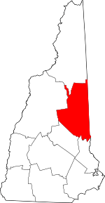 Map of New Hampshire highlighting Carroll County | |
| Township | ||
| CDPs | ||
| Other villages | ||
| Authority control |
|
|---|