Columbus Township, Bartholomew County, Indiana
Columbus Township is one of twelve townships in Bartholomew County, Indiana, United States. As of the 2010 census, its population was 45,578 and it contained 20,516 housing units.[1]
Columbus Township | |
|---|---|
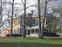 The D.W. Heagy Farmhouse, a historic site in the township | |
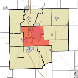 Location in Bartholomew County | |
| Coordinates: 39°12′42″N 85°56′06″W | |
| Country | United States |
| State | Indiana |
| County | Bartholomew |
| Government | |
| • Type | Indiana township |
| Area | |
| • Total | 55.61 sq mi (144.0 km2) |
| • Land | 54.94 sq mi (142.3 km2) |
| • Water | 0.66 sq mi (1.7 km2) 1.19% |
| Elevation | 617 ft (188 m) |
| Population (2010) | |
| • Total | 45,578 |
| • Density | 829.5/sq mi (320.3/km2) |
| ZIP codes | 47201, 47203 |
| GNIS feature ID | 0453243 |
History
The David Aikens House, D.W. Heagy Farm, New Hope Bridge, and James Marr House and Farm are listed on the National Register of Historic Places.[2]
Geography
According to the 2010 census, the township has a total area of 55.61 square miles (144.0 km2), of which 54.94 square miles (142.3 km2) (or 98.80%) is land and 0.66 square miles (1.7 km2) (or 1.19%) is water.[1] Camp Atterbury borders the township to the northwest.
Cities, towns, villages
- Columbus (south three-quarters)
Unincorporated towns
- Corn Brook
- East Columbus
- Everroad Park
- Flat Rock Park
- Forest Park
- Garden City
- Lowell
- North Columbus
- Parkside
(This list is based on USGS data and may include former settlements.)
Adjacent townships
- German Township (north)
- Flat Rock Township (northeast)
- Clay Township (east)
- Rock Creek Township (east)
- Sand Creek Township (southeast)
- Wayne Township (south)
- Ohio Township (southwest)
- Harrison Township (west)
Cemeteries
The township contains these five cemeteries: Carter, Garland Brook, Lambert, Mount Pleasant and Thompson.
Major highways


Airports and landing strips
- Bartholomew County Hospital Airport
Rivers
Lakes
- Crystal Lake
- Long Lake
- Terrace Lake
- Wood Lake
Landmarks
- Clifty Creek Park
- Donner Park
- Lincoln Park
- Noblitt Park
- Mill Race Park
School districts
- Bartholomew County School Corporation
Political districts
- Indiana's 6th congressional district
- State House District 57
- State House District 59
- State House District 65
- State Senate District 41
References
- United States Census Bureau 2007 TIGER/Line Shapefiles
- United States Board on Geographic Names (GNIS)
- United States National Atlas
- "Population, Housing Units, Area, and Density: 2010 - County -- County Subdivision and Place -- 2010 Census Summary File 1". United States Census. Archived from the original on 2020-02-12. Retrieved 2013-05-10.
- "National Register Information System". National Register of Historic Places. National Park Service. July 9, 2010.
External links
Municipalities and communities of Bartholomew County, Indiana, United States | ||
|---|---|---|
| City | Map of Indiana highlighting Bartholomew County | |
| Towns | ||
| Townships | ||
| CDP | ||
| Other unincorporated communities |
| |
| Ghost town | ||
| Footnotes | ‡This populated place also has portions in an adjacent county or counties | |