Indiana State Road 7
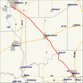
State Road 7 in the U.S. State of Indiana is located in southeast Indiana. It runs from northwest-to-southeast connecting the cities of Columbus and Madison.
| ||||
|---|---|---|---|---|
 | ||||
| Route information | ||||
| Maintained by INDOT | ||||
| Length | 36.549 mi[1] (58.820 km) | |||
| Major junctions | ||||
| South end | ||||
| North end | ||||
| Location | ||||
| Counties | Jefferson, Jennings, Bartholomew | |||
| Highway system | ||||
| ||||

History
Prior to 1926 the SR 7 designation was routed along the US 24 corridor. At this time modern SR 7 route was part of SR 26.[2] In 1926 the modern route of SR 7 was planned to become part of SR 11 designation.[3] Later in 1926 the SR 11 designation became SR 7, routed from Madison to Columbus.[4] Between 1931 and 1932 the entire route of SR 7 became a hard driving surface.[5][6] US 31 was rerouted onto SR 7 northwest of the modern intersection between the two roads between 1939 and 1941.[7][8] By 1942 US 31 was rerouted onto its modern route towards Columbus.[8][9] The northern end of SR 7 was moved to its current location, at SR 46, in either 1999 or 2000.[10][11]
Three bronze markers in Madison, North Vernon, and Columbus designate the road as the "Guthrie Trail". The markers were placed for former Indiana State Senator William Guthrie of Dupont in the 1920s, who was instrumental in the road becoming a state highway.
Major intersections
| County | Location | mi[1] | km | Destinations | Notes |
|---|---|---|---|---|---|
| Jefferson | Madison | 0.000 | 0.000 | Southern terminus of SR 7 | |
| 3.049 | 4.907 | ||||
| Lancaster Township | 7.869 | 12.664 | Eastern terminus of SR 250 | ||
| Jennings | Vernon | 21.620 | 34.794 | Southern end of SR 3 concurrency | |
| North Vernon | 23.768 | 38.251 | |||
| 25.842 | 41.589 | Northern end of SR 3 concurrency | |||
| Bartholomew | Elizabethtown | 35.985 | 57.912 | ||
| 36.549 | 58.820 | Northern terminus of SR 7 | |||
1.000 mi = 1.609 km; 1.000 km = 0.621 mi
| |||||
References
- Indiana Department of Transportation (July 2016). Reference Post Book (PDF). Indianapolis: Indiana Department of Transportation. Retrieved April 10, 2017.
- "Many State Highway Numbers Changed". The Hancock Democrat. Greenfield, IN. November 8, 1923. Retrieved June 2, 2017 – via Newspapers.com.

- "Road Numbers to Be Changed". The Hancock-Democrat. The Indianapolis News. September 30, 1926. Retrieved June 2, 2017 – via Newspapers.com.
- Indiana State Highway Commission (1926). State Highway System of Indiana (Map). Indianapolis: Indiana State Highway Commission. Retrieved June 2, 2017 – via Indiana State Library and Historical Bureau.
- Indiana State Highway Commission (September 30, 1931). State Highway System of Indiana (PDF) (Map). Indianapolis: Indiana State Highway Commission. Retrieved June 2, 2017 – via Indiana University Bloomington Libraries.
- Indiana State Highway Commission (January 1, 1932). State Highway System of Indiana (Map). 1:660,000. Indianapolis: Indiana State Highway Commission. OCLC 53092152. Retrieved June 2, 2017 – via Indiana State Library and Historical Bureau.
- Indiana State Highway Commission (1939). State Highway System of Indiana (Map). 1:633,600. Indiana State Highway Commission. OCLC 64016573. Retrieved June 2, 2017 – via Indiana State Library and Historical Bureau.
- Indiana State Highway Commission (1941). State Highway System of Indiana (Map). 1:633,600. Indiana State Highway Commission. OCLC 64574634. Retrieved June 2, 2017 – via Indiana State Library and Historical Bureau.
- Indiana State Highway Commission (1942). State Highway System of Indiana (Map). 1:720,000. Indiana State Highway Commission. OCLC 64382867. Retrieved June 2, 2017 – via Indiana State Library and Historical Bureau.
- Indiana Department of Transportation (1999). Indiana Transportation Map (Map). 1:633,600. Indianapolis: Indiana Department of Transportation. OCLC 47737740.
- Indiana Department of Transportation (2000). Indiana Transportation Map (Map). 1:650,000. Indianapolis: Indiana Department of Transportation. OCLC 70269263.
External links