Colorado State Highway 131
State Highway 131 (SH 131) is a 68.7 mi (110.6 km) long north–south state highway in the U.S. State of Colorado. SH 131's southern terminus is at Interstate 70 (I-70) in Wolcott, and the northern terminus is at U.S. Route 40 (US 40) 4 miles (6.4 km) east of Steamboat Springs. SH 131 travels through the towns of State Bridge, Bond, McCoy, Toponas, Yampa, and Oak Creek.
| ||||
|---|---|---|---|---|
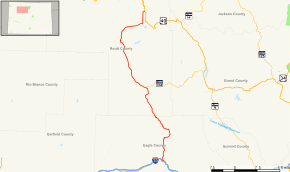 Map of northwestern Colorado with SH 131 highlighted in red | ||||
| Route information | ||||
| Maintained by CDOT | ||||
| Length | 68.7 mi[1] (110.6 km) | |||
| Major junctions | ||||
| South end | ||||
| North end | ||||
| Highway system | ||||
Colorado State Highways
| ||||


Highway 131 as it passes through Toponas, Colorado.
History
The route was established in the 1920s, when it connected State Bridge to its current terminus at US 40. The route was then paved from its north end to Yampa by 1946. SH 11 (now moved) was deleted by 1954, giving the section from Wolcott to State Bridge to SH 131. The entire route was paved by 1970. SH 131 was then extended to I-70 in 1972.[2]
Major intersections
| County | Location | mi | km | Destinations | Notes |
|---|---|---|---|---|---|
| Eagle | | 0.00 | 0.00 | Southern terminus; I-70 exit 157; interchange | |
| | 0.32 0.00 | 0.51 0.00 | Southern end of US 6 concurrency; mileposts reset | ||
| Wolcott | 0.05 | 0.080 | Northern end of US 6 concurrency | ||
| Routt | Toponas | 32.90 | 52.95 | Western terminus of SH 134 | |
| | 68.72 | 110.59 | Northern terminus | ||
1.000 mi = 1.609 km; 1.000 km = 0.621 mi
| |||||
References
- "Segment Descriptions for Highway 131". Colorado Department of Transportation. Retrieved 2008-05-14.
- Salek, Matthew E. "Colorado Routes 120-139". Retrieved 2010-05-29.
External links
This article is issued from Wikipedia. The text is licensed under Creative Commons - Attribution - Sharealike. Additional terms may apply for the media files.