Cloquet, Minnesota
Cloquet (/kloʊˈkeɪ/ (![]()
Cloquet | |
|---|---|
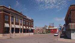 Downtown Cloquet | |
 Location of the city of Cloquet within Carlton County, Minnesota | |
| Coordinates: 46°43′18″N 92°27′34″W | |
| Country | United States |
| State | Minnesota |
| County | Carlton |
| Incorporated (village) | 1884 |
| Incorporated (city) | 1904 |
| Government | |
| • Mayor | Roger Maki |
| Area | |
| • Total | 36.01 sq mi (93.27 km2) |
| • Land | 35.21 sq mi (91.20 km2) |
| • Water | 0.80 sq mi (2.07 km2) 2.14% |
| Elevation | 1,207 ft (368 m) |
| Population | |
| • Total | 12,124 |
| • Estimate (2019)[3] | 12,009 |
| • Density | 339.02/sq mi (130.90/km2) |
| Time zone | UTC-6 (Central) |
| • Summer (DST) | UTC-5 (Central) |
| ZIP code | 55720 |
| Area code(s) | 218 |
| FIPS code | 27-12160 |
| GNIS feature ID | 0641345[4] |
| Website | www.ci.cloquet.mn.us |
History

Cloquet began as a group of small settlements around three sawmills: Shaw Town, Nelson Town, and Johnson Town. These later became known as Knife Falls after a local waterfall over sharp slate rocks, and later as Cloquet. The area was platted in 1883 and the village of Cloquet was incorporated from the three settlements in 1884. It became a city with a mayor and city council in 1904. The word "Cloquet" first appeared on a map of the area by Joseph N. Nicollet in 1843 which named the Cloquet River, a tributary of the Saint Louis River, and the Cloquet Rapids to the north. "Cloquet" is a French surname but historians researching the name of the river and city have found no definitive answer, and are reduced to speculations. One of these is that the river might have been named after 19th century French scientists, the Cloquet brothers Hipployte and Jules, with the settlement later being named after the river.[6]
The area was the site of the 1918 Cloquet Fire, which destroyed much of the town and killed approximately 500 people.
Cloquet is famed in American economic history because before and after World War II it was home of the strongest consumers cooperatives of the country. The Cloquet Coöperative Society (founded in 1910) operated two cooperative stores which handled food, hardware, shoes, dry goods, and furniture. Other cooperative services included a building supply store, a coal yard, a mortuary, an auto repair shop and a gas service station.
In 1939, the co-op did 35% of the business in the town, and 18% in Carlton County. By the mid-1950s, the consumer society had a membership of 4,262 out of a population of 8,500. This was a national record, given the fact that the total business of all American co-ops combined represented only 0.5% of the economy. The Finnish cooperative groups of the area also had an influence on the American cooperative movement in general.
In the 1970s the area of the city was increased to over ten times what it had been in 1970. Despite this, the population of the city still declined between 1970 and 1980, even though the number of separate residences in the city increased.[7]
Architecture
Cloquet is home to the R.W. Lindholm Service Station, the only gas station designed by architect Frank Lloyd Wright and a structure now on the National Register of Historic Places.
Geography
According to the United States Census Bureau, the city has a total area of 35.97 square miles (93.16 km2), of which, 35.20 square miles (91.17 km2) is land and 0.77 square miles (1.99 km2) is water.[8]
Cloquet is located along the Saint Louis River, 20 miles southwest of the city of Duluth.
Climate
Cloquet has a Humid continental climate (Köppen Climate Classification Dfb) typical of its location in northern Minnesota, with warm summers and long, cold winters.
| Climate data for Cloquet, Minnesota (1981–2010) | |||||||||||||
|---|---|---|---|---|---|---|---|---|---|---|---|---|---|
| Month | Jan | Feb | Mar | Apr | May | Jun | Jul | Aug | Sep | Oct | Nov | Dec | Year |
| Record high °F (°C) | 52 (11) |
57 (14) |
79 (26) |
88 (31) |
94 (34) |
98 (37) |
105 (41) |
98 (37) |
96 (36) |
86 (30) |
70 (21) |
57 (14) |
105 (41) |
| Average high °F (°C) | 20.4 (−6.4) |
26.5 (−3.1) |
37.9 (3.3) |
53.5 (11.9) |
66.9 (19.4) |
75.2 (24.0) |
80.0 (26.7) |
77.7 (25.4) |
68.0 (20.0) |
53.5 (11.9) |
36.5 (2.5) |
23.2 (−4.9) |
51.6 (10.9) |
| Average low °F (°C) | 1.4 (−17.0) |
5.4 (−14.8) |
16.5 (−8.6) |
28.5 (−1.9) |
38.6 (3.7) |
47.7 (8.7) |
54.0 (12.2) |
53.3 (11.8) |
45.3 (7.4) |
34.2 (1.2) |
21.7 (−5.7) |
7.0 (−13.9) |
29.5 (−1.4) |
| Record low °F (°C) | −45 (−43) |
−41 (−41) |
−35 (−37) |
−7 (−22) |
8 (−13) |
24 (−4) |
30 (−1) |
26 (−3) |
19 (−7) |
0 (−18) |
−24 (−31) |
−37 (−38) |
−45 (−43) |
| Average precipitation inches (mm) | 0.95 (24) |
0.83 (21) |
1.49 (38) |
2.32 (59) |
3.23 (82) |
4.24 (108) |
4.21 (107) |
4.00 (102) |
4.34 (110) |
3.12 (79) |
1.96 (50) |
1.14 (29) |
31.51 (800) |
| Average snowfall inches (cm) | 13.9 (35) |
11.0 (28) |
10.4 (26) |
3.7 (9.4) |
0.1 (0.25) |
0 (0) |
0 (0) |
0 (0) |
0 (0) |
1.2 (3.0) |
9.8 (25) |
14.0 (36) |
66.7 (169) |
| Average precipitation days (≥ 0.01 in) | 10 | 8 | 9 | 9 | 12 | 13 | 12 | 10 | 12 | 12 | 9 | 11 | 124 |
| Average snowy days (≥ 0.1 in) | 13 | 9 | 6 | 2 | 0 | 0 | 0 | 0 | 0 | 1 | 6 | 13 | 51 |
| Source: NOAA (extremes 1911–present)[9] | |||||||||||||
Demographics
| Historical population | |||
|---|---|---|---|
| Census | Pop. | %± | |
| 1880 | 93 | — | |
| 1890 | 2,530 | 2,620.4% | |
| 1900 | 3,072 | 21.4% | |
| 1910 | 7,031 | 128.9% | |
| 1920 | 5,127 | −27.1% | |
| 1930 | 6,782 | 32.3% | |
| 1940 | 7,304 | 7.7% | |
| 1950 | 7,685 | 5.2% | |
| 1960 | 9,013 | 17.3% | |
| 1970 | 8,699 | −3.5% | |
| 1980 | 11,142 | 28.1% | |
| 1990 | 10,885 | −2.3% | |
| 2000 | 11,201 | 2.9% | |
| 2010 | 12,124 | 8.2% | |
| Est. 2019 | 12,009 | [3] | −0.9% |
| U.S. Decennial Census[10] | |||
2010 census
As of the census[2] of 2010, there were 12,124 people, 4,959 households, and 3,126 families residing in the city. The population density was 344.4 inhabitants per square mile (133.0/km2). There were 5,235 housing units at an average density of 148.7 per square mile (57.4/km2). The racial makeup of the city was 84.4% White, 0.4% African American, 10.8% Native American, 0.5% Asian, 0.1% from other races, and 3.7% from two or more races. Hispanic or Latino of any race were 1.3% of the population.
There were 4,959 households, of which 32.9% had children under the age of 18 living with them, 43.1% were married couples living together, 14.4% had a female householder with no husband present, 5.6% had a male householder with no wife present, and 37.0% were non-families. 30.5% of all households were made up of individuals, and 12.9% had someone living alone who was 65 years of age or older. The average household size was 2.40 and the average family size was 2.96.
The median age in the city was 37 years. 25.5% of residents were under the age of 18; 8.9% were between the ages of 18 and 24; 25.5% were from 25 to 44; 25% were from 45 to 64; and 15.2% were 65 years of age or older. The gender makeup of the city was 48.7% male and 51.3% female.
2000 census
As of the census of 2000, there were 11,201 people, 4,636 households, and 2,967 families residing in the city. The population density was 317.9 people per square mile (122.7/km2). There were 4,805 housing units at an average density of 136.4 per square mile (52.6/km2). The racial makeup of the city was 88.21% White, 0.16% African American, 9.35% Native American, 0.39% Asian, 0.01% Pacific Islander, 0.13% from other races, and 1.75% from two or more races. Hispanic or Latino of any race were 0.63% of the population. 16.0% were of German, 15.4% Finnish, 12.4% Norwegian, 9.8% Swedish and 6.1% Polish ancestry.
There were 4,636 households, out of which 30.8% had children under the age of 18 living with them, 47.1% were married couples living together, 12.4% had a female householder with no husband present, and 36.0% were non-families. 31.0% of all households were made up of individuals, and 14.6% had someone living alone who was 65 years of age or older. The average household size was 2.38 and the average family size was 2.96.
In the city, the population was spread out, with 25.6% under the age of 18, 8.5% from 18 to 24, 27.5% from 25 to 44, 21.4% from 45 to 64, and 16.8% who were 65 years of age or older. The median age was 38 years. For every 100 females, there were 89.9 males. For every 100 females age 18 and over, there were 86.1 males.
The median income for a household in the city was $35,675, and the median income for a family was $47,799. Males had a median income of $40,140 versus $26,144 for females. The per capita income for the city was $17,812. About 7.7% of families and 9.9% of the population were below the poverty line, including 9.7% of those under age 18 and 12.4% of those age 65 or over.
Infrastructure
Major highways
Notable people
- U.W. "Judge" Hella, Director of Minnesota State Parks
- Jessica Lange, actress
- Jamie Langenbrunner, former NHL player
- Clarence Larson, chemist
- Corey Millen, former NHL player. Former head coach with Minnesota Wilderness
- Barbara Payton, actress
- Derek Plante, former NHL player. Currently an assistant coach with Minnesota-Duluth
- Daren Streblow, standup comedian
References
- "2017 U.S. Gazetteer Files". United States Census Bureau. Retrieved Jan 3, 2019.
- "U.S. Census website". United States Census Bureau. Retrieved 2012-11-13.
- "Population and Housing Unit Estimates". Retrieved May 21, 2020.
- "US Board on Geographic Names". United States Geological Survey. 2007-10-25. Retrieved 2008-01-31.
- "2010 Census Redistricting Data (Public Law 94-171) Summary File". American FactFinder. U.S. Census Bureau, 2010 Census. Retrieved 23 April 2011.
-
- O'Meara, Walter (1974). We Made It Through the Winter: A Memoir of Northern Minnesota Boyhood. St. Paul: Minnesota Historical Society. pp. 2, 115.
- Carroll, Francis M. (1987). Crossroads in Time: A History of Carlton County, Minnesota. Cloquet, Minnesota: The Carlton County Historical Society. pp. 203–5.
- Luukkonen, Larry; Wisuri, Marlene (2004). A Hometown Album: Cloquet's Centennial Story. Cloquet, Minnesota: Carlton County Historical Society. pp. 16–18.
- Guide of CLoquet, Minnesota
- "US Gazetteer files 2010". United States Census Bureau. Archived from the original on 2012-07-02. Retrieved 2012-11-13.
- "NOWData - NOAA Online Weather Data". National Oceanic and Atmospheric Administration. Retrieved May 29, 2016.
- United States Census Bureau. "Census of Population and Housing". Retrieved June 9, 2014.
- Florence C. Parker, The First 125 Years. A History of Distributive and Service Cooperation in the United States, 1829-1954 (Superior WI: CLUSA, 1956).
External links
| Wikimedia Commons has media related to Cloquet, Minnesota. |
Municipalities and communities of Carlton County, Minnesota, United States | ||
|---|---|---|
| Cities |  Map of Minnesota highlighting Carlton County | |
| Townships | ||
| CDPs | ||
| Unorganized territories | ||
| Unincorporated communities | ||
| Indian reservations | ||
| Footnotes | ‡This populated place also has portions in an adjacent county or counties | |
| Core cities |   | ||||
|---|---|---|---|---|---|
| Surrounding communities |
| ||||
| Counties |
| ||||