Cima Dome & Volcanic Field National Natural Landmark
The Cima Dome & Volcanic Field National Natural Landmark, or Cinder Cones National Natural Landmark, includes the Cima Dome, Cima Volcanic Field, and Cima Volcanic Range, and is in the Mojave Desert within San Bernardino County, California, United States.
| Cima Dome | |
|---|---|
 | |
| Highest point | |
| Elevation | 2,132 to 4,950 feet (650 to 1,509 m) |
| Coordinates | 35°17′22″N 115°35′07″W [1] |
| Geography | |
 Cima Dome California  Cima Dome Cima Dome (the United States) | |
| Location | San Bernardino County, California, U.S. |
| Geology | |
| Age of rock | 80–180 million years[2] |
| Mountain type | granitic pluton dome |
| Climbing | |
| Designated | 1973 |
| Cima Volcanic Range | |
|---|---|
| Highest point | |
| Elevation | 2,132 to 4,950 feet (650 to 1,509 m)[3] |
| Coordinates | 35°15′N 115°45′W [3] |
| Geography | |
| Location | Mojave Desert, San Bernardino County, California, U.S. |
| Geology | |
| Age of rock | 7.6 million years[4] |
| Mountain type | basalt |
| Last eruption | About 10,000 years ago[4] |
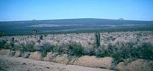
The dome and volcanic field with cinder cones are located within the National Park Service Mojave National Preserve south of Interstate 15 and Baker, off Kelbaker Road towards Cima, and north of the Kelso Visitors Center and Interstate 40.[3][5] The Joshua tree forest covering Cima Dome and the adjacent Shadow Valley is the largest and densest in the world.[6]
Cima Dome
Cima Dome is a broad sloping upland dome, the erosional remnant of granite plutons that formed deep under the Earth's surface 180–80 million years ago [2] when the Farallon Plate was being subducted beneath the North American Plate.
The dome rises 1,500 feet (460 m) above the volcanic plain, 2,132 to 4,950 feet (650 to 1,509 m) high, and covers 70-square-mile (180 km2). Cima Dome is an extremely symmetric dome of this granitic formation type, and one of the most visible ones by being in open desert plains.
Cima Volcanic Field and Range
The Cima Volcanic Field and Cima Volcanic Range includes 40 volcanic cinder cone vents, and extensive basaltic lava flows in a volcanic field covering more than 58 sq mi (150 km2) of the Mojave Desert. It ranges from 2,132 to 4,950 feet (650 to 1,509 m) in elevation. These cinder cones range in size from 82 to 508 ft (25 to 155 m) in height above the volcanic plain and from 656 to 3,018 ft (200 to 920 m) in base diameters. Over 30 of these cinder cones and associated lava flows, are Pleistocene in age and are located in the southern portion of the volcanic field, with the rest from the Quaternary age.[7][5]
See also
- Lavic Lake volcanic field
- Pisgah Crater - Mojave volcanism information
- Amboy Crater
- Mojave National Preserve
- Coso Volcanic Field
References
- "Cima Dome". Geographic Names Information System. United States Geological Survey. Retrieved 2012-12-17.
- "Cima Dome". Geology of Mojave National Preserve. National Park Service. 1999-03-22. Retrieved 2008-08-11.
- "Cima, California". VolcanoWorld. Archived from the original on 2008-09-26. Retrieved 2008-08-11.
- "America's Volcanic Past - Mojave National Preserve". Cascades Volcano Observatory. United States Geological Survey. 2003-01-27. Archived from the original on 2008-05-17. Retrieved 2008-08-11.
- "Cinder Cones". Geology of Mojave National Preserve. USGS. 1999-03-24. Archived from the original on June 13, 2011. Retrieved 2010-07-11.
- "General Management Plan-Introduction" (PDF). National Park Service. p. 7. Retrieved 2009-05-06.
- Dohrenwend, J.C.; Wells, S.G.; Turrin, B.D. (April 1986). "Degradation of Quaternary cinder cones in the Cima volcanic field, Mojave Desert, California" (PDF). Geological Society of America Bulletin. Geological Society of America. 97 (4): 421–427. doi:10.1130/0016-7606(1986)97<421:DOQCCI>2.0.CO;2. Archived from the original (PDF) on 2009-06-12. Retrieved 2009-06-19.