Lavic Lake volcanic field
The Lavic Lake volcanic field is a volcanic field with extinct cinder cones in the Mojave Desert, in San Bernardino County, California, United States. The lava field, at 762 m (2,500 ft) elevation, and its cones are directly alongside historic Route 66 and from Interstate 40, between Barstow to the west and Ludlow to the east, and is located 10 miles directly west of Ludlow, California.[1]
Description
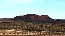
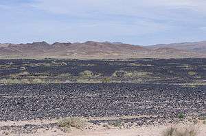
The 100 km2 (39 sq mi) Lavic Lake volcanic field is a basaltic pahoehoe lava plain and has four Holocene (approximately 10,000 years ago) cinder cone type volcanos, three in the Lavic Dry Lake area, and a fourth located southwest in the Rodman Mountains.[1][2] The oldest cinder cone, Pisgah Crater may be pre-Holocene, erupting around 25,000 years ago.[2]
Of the four cinder cones, Pisgah Crater stands as the most accessible and prominent volcano in the volcanic field with a height of 100 m (330 ft) above the field with a peak elevation of 2,545 feet (776 m), at 34°44′47″N 116°22′30″W. The cone of Pisgah Crater has been modified by mining operations that provide a source of road aggregate.[1]
The biome is the deserts and xeric shrublands, with smaller plants growing in soil pockets formed by erosion, sedimentation and wind deposits.
See also
References
- Global Volcanism Program, 2013. Lavic Lake (323190) in Volcanoes of the World, v. 4.6.7. Venzke, E (ed.). Smithsonian Institution. Downloaded 15 May 2018 (http://volcano.si.edu/volcano.cfm?vn=323190). https://doi.org/10.5479/si.GVP.VOTW4-2013
- "Lavic Lake Volcanic Field". United States Geological Survey. Retrieved 2012-02-13.