Choco District
Choco District is one of fourteen districts of the province Castilla in Peru.[1]
Choco | |
|---|---|
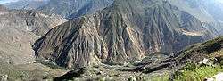 Apachita mountain and Qullqa River on the border of the districts of Choco (on the left) and Tapay | |
| Country | |
| Region | Arequipa |
| Province | Castilla |
| Founded | January 2, 1857 |
| Capital | Choco |
| Government | |
| • Mayor | Trifonio Lucas Aragon Lupaca |
| Area | |
| • Total | 904.33 km2 (349.16 sq mi) |
| Elevation | 2,473 m (8,114 ft) |
| Population (2005 census) | |
| • Total | 1,235 |
| • Density | 1.4/km2 (3.5/sq mi) |
| Time zone | UTC-5 (PET) |
| UBIGEO | 040406 |
Geography
The Chila mountain range traverses the district. One of the highest mountains of the district is Chila at 5,654 m (18,550 ft) above sea level. Other mountains are listed below:[2]
- Anta Qullu
- Anta Willkaña
- Apachita
- Ayri Qutu
- Chuqu Chuqu
- Chuqi Pirwa
- Chuqiwa
- Chila
- Janq'u Quta
- Kampanayuq
- Kiska P'anqa
- Kuntur
- Kuntur K'ark'a
- Kuntur
- Mawras
- Mulluq'u Pampa
- Panti
- Phusuqu
- P'isaqa
- Qallwa
- Qiñwa
- Qura
- Q'asiri
- Q'illa Q'illa
- Sama Q'asa
- Sirani
- Sukna
- Suntur Uta
- Taypi Q'asa
- Uqi Q'asa
- Uqha Q'asa
- Urqun Ikiña
- Wallatani
- Warana
- Wat'aña
- Wamani
- Waña Qutaki
- Waraquyuq
- Waywa Wawa
- Wit'u
- Yuraq Q'asa
Ethnic groups
The people in the district are mainly indigenous citizens of Quechua descent. Quechua is the language which the majority of the population (67.11%) learnt to speak in childhood, 32.23% of the residents started speaking using the Spanish language (2007 Peru Census).[3]
References
- (in Spanish) Instituto Nacional de Estadística e Informática. Banco de Información Distrital Archived April 23, 2008, at the Wayback Machine. Retrieved April 11, 2008.
- escale.minedu.gob.pe - UGEL maps of the Caylloma Province 1 and 2 (Arequipa Region)
- inei.gob.pe Archived January 27, 2013, at the Wayback Machine INEI, Peru, Censos Nacionales 2007, Frequencias: Preguntas de Población: Idioma o lengua con el que aprendió hablar (in Spanish)
This article is issued from Wikipedia. The text is licensed under Creative Commons - Attribution - Sharealike. Additional terms may apply for the media files.