Lari District
Lari District is one of twenty districts of the province Caylloma in Peru.[1]
Lari | |
|---|---|
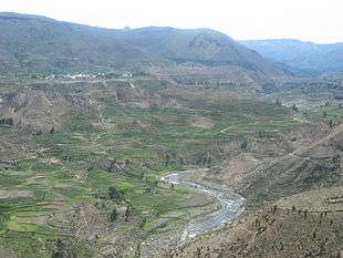 Colca River with the village of Lari in the background | |
| Country | |
| Region | Arequipa |
| Province | Caylloma |
| Capital | Lari |
| Government | |
| • Mayor | Abel Abdon Llallacachi Silloca |
| Area | |
| • Total | 384.02 km2 (148.27 sq mi) |
| Elevation | 3,330 m (10,930 ft) |
| Population (2005 census) | |
| • Total | 1,370 |
| • Density | 3.6/km2 (9.2/sq mi) |
| Time zone | UTC-5 (PET) |
| UBIGEO | 040510 |
Geography
The Ch'ila mountain range traverses the district. One of the highest elevations of the district is Mismi at 5,597 m (18,363 ft) above sea level. Other mountains are listed below:[2]
|
|
Images
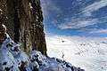 Mismi on the border of the districts of Lari and Ichupampa
.jpg) Fields at the Colca River in the Lari District
Fields at the Colca River in the Lari District
See also
References
- (in Spanish) Instituto Nacional de Estadística e Informática. Banco de Información Distrital Archived 2008-04-23 at the Wayback Machine. Retrieved April 11, 2008.
- escale.minedu.gob.pe - UGEL maps of the Caylloma Province 1 and 2 (Arequipa Region)
This article is issued from Wikipedia. The text is licensed under Creative Commons - Attribution - Sharealike. Additional terms may apply for the media files.