China–North Korea border
The China–North Korea border is the international border separating the People's Republic of China (PRC) and the Democratic People's Republic of Korea (North Korea).
 Inscription stone marking the border of China and North Korea in Jilin | |||||||
| Chinese name | |||||||
|---|---|---|---|---|---|---|---|
| Simplified Chinese | 中朝边境 | ||||||
| Traditional Chinese | 中朝邊境 | ||||||
| |||||||
| Korean name | |||||||
| Chosŏn'gŭl | 조선민주주의인민공화국-중화인민공화국 국경 | ||||||
| Hancha | 朝鮮民主主義人民共和國·中華人民共和國 國境 | ||||||
| Revised Romanization | Joseon Minjujuui Inmin Gonghwaguk – Junghwa Inmin Gonghwaguk Gukgyeong | ||||||
| McCune–Reischauer | Chosŏn Minjujuŭi Inmin Konghwagukᆞ – Chunghwa Inmin Konghwaguk Kukkyŏng | ||||||
Geography

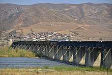
The border is 1,420 kilometres (880 mi) long.[1] From west to east, the Yalu River,[2] Paektu Mountain, and the Tumen River divides the two countries.
Dandong, in the Liaoning Province of China, on the Yalu River delta, is the largest city on the border.[3] On the other side of the river is the city of Sinuiju in North Pyongan Province, North Korea. The two cities are situated on the Amnok river delta at the western end of the border, near the Yellow Sea. Their waterfronts face each other and are connected by the Sino-Korean Friendship Bridge.
There are 205 islands on the Amnok River. A 1962 border treaty between North Korea and China split the islands according to which ethnic group were living on each island. North Korea possesses 127 and China 78. Due to the division criteria, some islands such as Hwanggumpyong Island belong to North Korea even though they are on the Chinese side of the river. Both countries have navigation rights on the river, including in the delta.
The source of the Amnok River is Heaven Lake on Paektu Mountain, which is considered the birthplace of the Korean and Manchu peoples. This lake is also the source of the Tumen River which forms the eastern portion of the border.
There are a significant number of ethnic Koreans in Northeast China, particularly in the Yanbian Korean Autonomous Prefecture.
Trade and contact

Its border with China has been described as North Korea's "lifeline to the outside world."[1] Much of the China-North Korea trade goes through the port of Dandong.[2]
Chinese cell phone service has been known to extend as far as 10 km (6 mi) into Korean territory, which has led to the development of a black market for Chinese cell phones in the border regions. International calls are strictly forbidden in North Korea, and violators put themselves at considerable peril to acquire such phones.[4]
Tourists in Dandong can take speedboat rides along the North Korean side of the Amnok River and up its tributaries.[5]
A common wedding day event for many Chinese couples involve renting boats, putting life preservers on over their wedding clothes, and going to the North Korean border to have wedding photos taken.[6]
Memory cards and teddy bears are reportedly among the most popular items for North Koreans shopping in Dandong.[7]
Crossings

| China-North Korea Border Crossings | |||||
|---|---|---|---|---|---|
| Name | Bordering Chinese town |
Bordering Korean town |
Open to third country nationals |
Railway crossing | Notes |
| Hwanggumpyong Island | Tangchi, Zhenxing, Dandong | Sindo, North Pyongan Province | No | No | Planned |
| New Yalu River Bridge | Tangchi, Zhenxing, Dandong | Sinuiju, North Pyongan | Yes | No | Under construction |
| Yalu River Broken Bridge | Tangchi, Zhenxing, Dandong | Sinuiju, North Pyongan | No | No | Defunct |
| Sino-Korean Friendship Bridge | Tangchi, Zhenxing, Dandong | Sinuiju, North Pyongan | Yes | Yes | Opened[lower-alpha 1] |
| Yalu River Broken Wooden Pontoon | Zhenzhu Subdistrict, Zhen'an, Dandong | Sinuiju, North Pyongan | No | Yes | Defunct |
| Hekou Broken Bridge | Changdian, Kuandian, Dandong | Sakchu County, North Pyongan | No | No | Defunct |
| Upper Hekou Railway Bridge | Changdian, Kuandian, Dandong | Sakju, North Pyongan | No | Yes | Opened |
| Ji'an Railway Bridge | Ji'an City, Tonghua | Manpo, Chagang | No | Yes | Opened |
| Ji'an Road Bridge | Ji'an City, Tonghua | Manpo, Chagang | No | No | Opened |
| Chagang Samgang Railway Bridge | Yunfeng Lake, Ji'an, Tonghua | Manpo, Chagang | No | Yes | Defunct |
| Kuunbong Railway Bridge | Yunfeng Lake, Ji'an, Tonghua | Chasong, Chagang | No | Yes | Defunct |
| Linjiang Yalu River Bridge | Linjiang City, Baishan | Chunggang, Chagang | No | No | Opened |
| Changbai-Hyesan Bridge | Changbai, Baishan | Hyesan, Ryanggang Province | No | No | Opened |
| Karim Bridge | Ershidaogou, Changbai, Baishan | Pochon, Ryanggang | No | No | Defunct |
| Samjiyon crossing | Erdaobaihe, Antu, Yanbian | Samjiyon, Ryanggang | No | No | Near Paektu Mountain |
| Guchengli Bridge | Chongshan, Helong, Yanbian | Taehongdan, Ryanggang | No | No | Opened |
| Nanping Bridge | Nanping, Helong, Yanbian | Musan, North Hamgyong | No | No | Opened |
| Sanhe Bridge | Sanhe, Longjing, Yanbian | Hoeryong, North Hamgyong | No | No | Opened |
| Chaokai Bridge | Kaishantun, Longjing, Yanbian | Sambong, Onsong, North Hamgyong | No | No | Opened |
| Tumen Border Railway Bridge | Tumen City, Yanbian | Namyang, Onsong, North Hamgyong | Yes | Yes | Opened |
| New Tumen Border Bridge | Tumen City, Yanbian | Namyang, Onsong, North Hamgyong | Yes | No | Under Construction |
| Tumen Border Road Bridge | Tumen City, Yanbian | Namyang, Onsong, North Hamgyong | Yes | No | Opened |
| Liangshui Broken Bridge | Liangshui, Tumen, Yanbian | Onsong, North Hamgyong | No | No | Defunct |
| Hunyung Railway Bridges | Ying'an, Hunchun, Yanbian | Hunyung, Kyongwon, North Hamgyong | No | Yes | Defunct |
| Shatuozi Bridge | Sanjiazi, Hunchun, Yanbian | Kyongwon, North Hamgyong | No | No | Opened |
| Quanhe-Yunting Bridge | Jingxin (敬信镇), Hunchun, Yanbian | Wonjong, Rason | Yes | No |
Opened[lower-alpha 2] |
| |||||

Border security

The 1,420 km border between North Korea and China has been described as "porous".[1] Many North Korean defectors cross into China.
The Chinese government transferred responsibility for managing the border to the army from the police in 2003.[10] Chinese authorities began building wire fences "on major defection routes along the Tumen River" in 2003.[11] Beginning in September 2006,[11] China erected a 20 kilometres (12 mi) fence on the border near Dandong, along stretches of the Yalu River delta with lower banks and narrower width.[2] The concrete and barbed wire fence ranged in height from 8 feet (2.4 m) to 15 feet (4.6 m).[11]
In 2007, a U.S. official stated that China was building more "fences and installations at key border outposts".[12] In the same year, it was reported that North Korea had started building a fence along a 10 kilometres (6.2 mi) stretch of its side of the Yalu River, and had also built a road to guard the area.[13][14]
In 2011, it was reported that China was building fences 4 metres (13 ft) high near Dandong, and that 13 kilometres (8.1 mi) of this new fencing had been built. It was also reported that China was reinforcing patrols, and that new patrol posts were being built on higher ground to give wider visibility over the area. According to a resident of the area: "It's the first time such strong border fences are being erected here. Looks like it is related to the unstable situation in North Korea." The resident also added that previously "anybody could cross if they really wanted" as the fence had only been 10 feet (3.0 m) with no barbed wire.[15][16]
In 2014, an Australian journalist who visited Dandong reported a low level of border security.[17][18] In 2015, fencing was reported as the exception rather than the rule.[19] In 2015, a photojournalist who traveled along the Chinese side of the border commented that fencing was rare and that it would be easy to cross the Amnok river when it was frozen. The same report noted friendly contact between people on opposite sides of the border.[20] In 2018, a photojournalist drove along the border and described it as "mile after mile of nothing, guarded by no-one".[21]
In 2015, a single rogue North Korean soldier killed four ethnic Korean citizens of China who lived along the border of China with North Korea.[22]
Rumours of Chinese troop mobilizations on the border frequently circulate in times of heightened tension on the Korean peninsula. According to scholar Adam Cathcart, these rumours are hard to substantiate and hard to interpret.[23]
A leaked China Mobile document that went viral on Chinese social media on 7 December 2017 allegedly revealed Chinese government plans to construct five "refugee settlement points" along the border to North Korea in Changbai county and Jilin province.[24][25] This was apparently in preparation for a large influx of North Korean refugees if the Kim regime collapsed in a potential conflict with the United States. The Guardian quoted the document: "Due to cross-border tensions … the [Communist] party committee and government of Changbai county has proposed setting up five refugee camps in the county."[26]
Notes
- from map: "DELINEATION OF INTERNATIONAL BOUNDARIES MUST NOT BE CONSIDERED AUTHORITATIVE"
- from map: "THE REPRESENTATION OF INTERNATIONAL BOUNDARIES ON THIS MAP IS NOT NECESSARILY AUTHORITATIVE."
References
- Onishi, Norimitsu. "Tension, Desperation: The China-North Korean Border Archived 2017-05-06 at the Wayback Machine." The New York Times. October 22, 2006. Retrieved on October 23, 2012.
- Kanto, Dick K. and Mark E. Manyin. China-North Korea Relations Archived 2017-12-28 at the Wayback Machine, Congressional Research Service (December 28, 2010).
- Rogers, Jenny. "New group reaches out to China Archived 2012-10-06 at the Wayback Machine." Gold Coast Bulletin. October 2, 2012. Retrieved on October 23, 2012.
- "North Korea: On the net in world's most secretive nation (BBC)". Archived from the original on 2018-10-23. Retrieved 2018-07-21.
- "A trip to the North Korea-China border, in photos". NK News. 29 May 2015. Archived from the original on 17 June 2016. Retrieved 6 June 2016.
- Hessler, Peter (2006). Oracle Bones. New York et al.: Harper Perennial. pp. 62.
- Reuters (4 December 2016). "Thanks for the memory cards; North Koreans return from China". www.atimes.com. Archived from the original on 7 December 2016. Retrieved 7 December 2016.
- "Trans-Siberian Railway Tours" Accessed 2014-05-25
- "North Korea Fast-Tracks Entry Visas For Rason SEZ". 2016-09-26. Archived from the original on 2019-01-04. Retrieved 2019-01-04.
- Foley, James. “China Steps Up Security on North Korean Border”, Jane's Intelligence Review, 1 November 2003.
- Ng Gan Guan, China Erects Fence Along N. Korea Border Archived 2018-04-28 at the Wayback Machine, Associated Press (October 16, 2006).
- "www.dailynk.com "China Troops Increase at North Korean Border"". Archived from the original on 2015-09-23. Retrieved 2014-10-17.
- www.edmontonsun.com "North Korea building fence on China border"
- "Report: N. Korea building fence to keep people in". Houston Chronicle. Archived from the original on 1 May 2011. Retrieved 4 July 2009.
- Foster, Peter and agencies, Beijing. "China builds higher fences over fears of instability in North Korea Archived 2018-05-02 at the Wayback Machine." The Daily Telegraph. March 30, 2011. Retrieved on October 26, 2012.
- "China boosts North Korea border fence Archived 2014-10-21 at the Wayback Machine." The China Post. Thursday March 31, 2011. Retrieved on October 26, 2012.
- Hardy, Elle (18 September 2014). "Comment: The absurdities faced by North Korean refugees in China". SBS News. Archived from the original on 11 October 2014. Retrieved 7 October 2014.
- "Comment: The absurdities faced by North Korean refugees in China". Archived from the original on 2014-10-11. Retrieved 2014-10-07.
- Rob York (25 February 2015). "The myth of a sealed China-N. Korea border". NK News. Archived from the original on 6 March 2016. Retrieved 25 April 2016.
- "A trip to the North Korea-China border, in photos". NK News. 29 May 2015. Archived from the original on 17 June 2016. Retrieved 6 June 2016.
- Sagolj, Damir (15 April 2018). "A road trip on the edge of North Korea". Reuters. Archived from the original on 21 April 2018. Retrieved 20 April 2018.
- https://www.yahoo.com/news/runaway-n-korean-soldier-kill-four-chinese-reports-060526414.html?bcmt=1420505551797-974622bd-2486-431b-8e29-2290873790fc&ref=gs Archived 2016-09-20 at the Wayback Machine https://www.yahoo.com/news/china-village-defenceless-against-north-korean-intruders-055043942.html?ref=gs Archived 2016-09-20 at the Wayback Machine
- Cathcart, Adam (20 October 2017). "Tigers in the Haze: Chinese Troops on the Border with North Korea in the 'April Crisis'". China Brief, Jamestown University. Archived from the original on 29 October 2017. Retrieved 29 October 2017.
- "US-North Korea tensions fuel fears on Chinese border". Financial Times. 10 December 2017. Archived from the original on 13 December 2017.
- Perlez, Jane (2017-12-11). "Fearing the Worst, China Plans Refugee Camps on North Korean Border". The New York Times. ISSN 0362-4331. Archived from the original on 2017-12-13. Retrieved 2017-12-13.
- Phillips, Tom (2017-12-12). "China building network of refugee camps along border with North Korea". The Guardian. ISSN 0261-3077. Archived from the original on 2017-12-13. Retrieved 2017-12-13.
External links
| Wikimedia Commons has media related to China-North Korea border. |