North Korea–Russia border
The North Korea–Russia border, according to the official Russian definition, consists of 17 kilometres (11 mi) of "terrestrial border" and 22.1 km (12 nautical miles) of "maritime border". It is the shortest of the international borders of Russia.[1]
Description

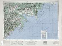
The terrestrial boundary between Russia and North Korea runs along the thalweg of the Tumen River and its estuary, while the maritime boundary separates the two countries' territorial waters in the Sea of Japan.[2]
The principal border treaty was signed on April 17, 1985.[3] A separate, trilateral treaty specifies the position of the China–North Korea–Russia tripoint.[4] The North Korea–Russia and China–North Korea borders run along the middle of the Tumen River, while the China–Russia border approaches the junction point overland from the north. Because the theoretical tripoint is in the middle of the river, where it would be impractical to install a border monument, the agreement provides instead that the three countries install border monuments on the riverbank, and that the position of the tripoint be determined with respect to those monuments.[4]
The administrative unit on the Russian side of the border is the Khasansky District of Primorsky Krai; on the Korean side, it is the city of Rason. The main Russian border guard station in the area is Peschanaya.
Border crossing

There is one crossing on the North Korea–Russia border: the Friendship Bridge over the Tumen River,[2] 800 metres (2,600 ft) southwest of the train station in Khasan, Russia. On the North Korean side, the border train station is at Tumangang. The crossing is railway-only, used by freight and passenger trains,[2] but planks laid between the tracks make crossing of road vehicles possible by special arrangement.
Passenger train service over the Friendship Bridge includes a Khasan–Tumangang shuttle, as well as a Korean State Railway direct car on the Moscow–Pyongyang route. The direct car travels from Moscow to Ussuriysk with a Moscow–Vladivostok train, to Khasan with an Ussuriysk–Khasan train, across the border with the Khasan–Tumangang shuttle train, and then to Pyongyang with a domestic Korean train. At 10,272 km (6,383 mi) total, this is the longest direct (one-seat ride) passenger rail service in the world.[5]
Normally, the crossing is used only by citizens of Russia and North Korea, and is not open to nationals of other countries. In 2008, however, two Western tourists managed to enter North Korea from Russia by taking a train over the Friendship Bridge.[5] In 2019, a Western-run travel agency specializing in North Korea tourism announced a Moscow–Pyongyang train tour that would also use the Khasan–Tumangang border crossing.[6]
In April 2015, the deputy transport ministers of Russia and North Korea—Nikolai Asaul and Kwok Il-ryong, respectively—signed an agreement to develop a road connection between the two countries.[7]
History
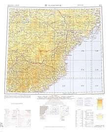
The border between the Russian Empire and the Qing dynasty, including its tributary Korean Kingdom was established by the Convention of Peking in November 1860. Under the agreement, the Qing dynasty ceded territories east of the Ussuri River to the Russians. The original description of the border included the lower course of the Tumen River—the last 20 li (about 10.75–13 kilometres or 6.68–8.08 miles)—as its southernmost section.[8][9]
The existence of Korea as a separate country was not mentioned in the 1860 convention between Russia and China, but in the late 19th and early 20th centuries, Chinese influence in Korea waned and Japanese influence grew. The Treaty of Shimonoseki in 1895 ended the Imperial Chinese tributary system over Korea, and the Japan–Korea Treaty of 1905 made Korea a protectorate of Japan. The Japan–Korea Treaty of 1910 finalized Japan's annexation of Korea. Thus, the Tumen River became a border between the Russian Empire (later, the Soviet Union) and the Japanese Empire; this continued until the end of Japanese rule in Korea in 1945.
Regardless of who ruled Korea, the coastal strips of Russian and Korean territory always separated China from the Sea of Japan.
In 1938, to develop the natural resources of its coastal strip and to protect its borders against a potential Japanese invasion, the Soviet Union began construction on a railway line from Baranovsky Junction (on the Trans-Siberian Railway) to Kraskino. The 190-kilometre (120 mi) route was completed in 1941. After World War II, it was extended from Kraskino to Khasan, on the Korean border, bringing its length to 238 km (148 mi). The Khasan station opened on September 28, 1951. Soon after, a temporary wooden bridge was built across the Tumen River, and in 1952, the first train crossed from the Soviet Union to North Korea.
In 1990, the Soviet Union and North Korea signed an agreement establishing a border along the fairway of the Tumen. The former Noktundo Island, 32 square kilometres (12 sq mi) in size, was recognized by North Korea as part of Russia. This agreement was not accepted by South Korea, which continues to view Noktundo as Korean territory.
In the second half of the 20th century, thousands of North Korean refugees and displaced people crossed the border. Their descendants now live throughout Russia and other Commonwealth of Independent States countries.
Riverbank protection
Because the North Korean side of the river is mountainous and the Russian side is lower, shore erosion may cause the Tumen River, which floods annually, to gradually change its course toward the Russian side. (A similar phenomenon is seen on the China–Russia border, with the Amur River.) To prevent the loss of national territory, and to shield Khasan and the Peschanaya border guard station from flooding, Russian authorities carried out a riverbank protection project using rock fill from 2004–2008.[10]
References
- See the tables at Сопредельные страны Archived July 8, 2015, at the Wayback Machine (Neighboring countries), at the Russia's border agency's (Rosgranitsa) official site
- Северная Корея Archived July 7, 2015, at the Wayback Machine (North Korea), at the Russia's border agency's (Rosgranitsa) official site
- Информация о международных соглашениях Archived July 8, 2015, at the Wayback Machine (Information on international agreements)
- Соглашение между Правительством Российской Федерации, Правительством Китайской Народной Республики и Правительством Корейской Народно-Демократической Республики об определении линии разграничения пограничных водных пространств трех государств на реке Туманная Archived July 2, 2015, at the Wayback Machine (Agreement between the Government of the Russian Federation, the Government of the People's Republic of China, and the Government of the People's Democratic Republic of Korea, determining the line of delimitation of the water spaces of the three states on the Tumen River) (in Russian)
- Entering North Korea at Tumangan, part of the series, The forbidden railway: Vienna - Pyongyang 윈 - 모스크바 - 두만강 - 평양. Our train trip via Russia to North Korea - using an officially closed to foreigners route inside the "Hermit Kingdom". See other parts of the series for train route details etc.
- "Moscow to Pyongyang by Train Tour". Young Pioneer Tours. Archived from the original on March 26, 2019. Retrieved March 27, 2019.
- North Korea, Russia sign road connection deal Archived February 6, 2016, at the Wayback Machine, 2015-04-16
- See Article 1 of the 1860 agreement between the Russian Empire and the Qing Empire (大清國): s:ru:Пекинский договор (1860), s:zh:中俄北京條約
- Alyssa Park, From Fluid Borderland to Divided Spaces: Transformation of the Russian-Korean Borderland, 1860-1937 Archived March 4, 2016, at the Wayback Machine (research proposal).
- Работы по укреплению берегов реки Туманной на границе России и КНДР завершатся в этом году Archived March 25, 2009, at the Wayback Machine (The Tumen riverbank protection work will be completed this year), 2008-02-21
External links
| Wikimedia Commons has media related to North Korea-Russia border. |
- The Tumen River Documentation Project at Sino-NK
- Frank Jacobs, Manchurian Trivia February 21, 2012
- Photo of border
- International Boundary Study No. 59 – December 5, 1965 Korea – U.S.S.R. Boundary