Chiang Klang District
Chiang Klang (Thai: เชียงกลาง, pronounced [t͡ɕʰīa̯ŋ klāːŋ]) is a district (amphoe) in the northern part of Nan Province, northern Thailand.
Chiang Klang เชียงกลาง | |
|---|---|
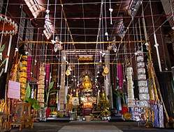 Inside the ubosot of Wat Nong Daeng | |
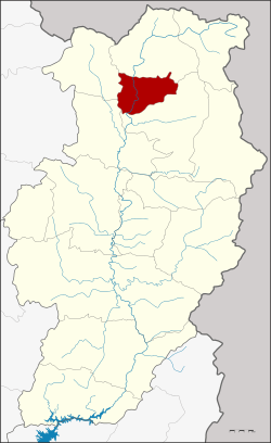 District location in Nan Province | |
| Coordinates: 19°17′30″N 100°51′42″E | |
| Country | Thailand |
| Province | Nan |
| Government | |
| • Marshal | Prasat Parkthup |
| Area | |
| • Total | 277.115 km2 (106.995 sq mi) |
| Population (2009) | |
| • Total | 28,234 |
| • Density | 100/km2 (260/sq mi) |
| Time zone | UTC+7 (ICT) |
| Postal code | 55160 |
| Geocode | 5509 |
Geography
Neighbouring districts are, from the north clockwise, Thung Chang, Pua, Tha Wang Pha and Song Khwae.
The eastern part of the district is in the Luang Prabang Range mountain area of the Thai highlands.[1]
History
The minor district (king amphoe) was created on 20 June 1968, when the four tambons, Puea, Chiang Klang, Chiang Khan, and Na Rai Luang, were split off from Thung Chang District.[2] It was upgraded to a full district on 16 November 1971.[3]
Administration
The district is divided into six sub-districts (tambons), which are further subdivided into 59 villages (mubans). There are two townships (thesaban tambon) in Chiang Klang District. The first one is Chiang Klang, which covers parts of tambon Chiang Klang, Puea, and Phaya Kaeo. Another is Phra Phutthabat Chiang Khan, which covers tambons Phra Phutthabat and Chiang Khan. There are a further four tambon administrative organizations (TAO).
| No. | Name | Thai name | Villages | Pop. | |
|---|---|---|---|---|---|
| 1. | Chiang Klang | เชียงกลาง | 12 | 7,643 | |
| 2. | Puea | เปือ | 15 | 6,970 | |
| 3. | Chiang Khan | เชียงคาน | 5 | 1,699 | |
| 4. | Phra That | พระธาตุ | 10 | 3,860 | |
| 8. | Phaya Kaeo | พญาแก้ว | 7 | 3,412 | |
| 9. | Phra Phutthabat | พระพุทธบาท | 10 | 5,289 |
The missing numbers are the tambon which now form Song Khwae District.
Gallery
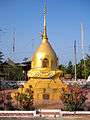 The chedi of Wat Nong Daeng
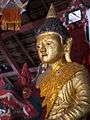 The main Buddha image of Wat Nong Daeng
References
- ดร.กระมล ทองธรรมชาติ และคณะ, สังคมศึกษา ศาสนาและวัฒนธรรม ม.1, สำนักพิมพ์ อักษรเจริญทัศน์ อจท. จำกัด, 2548, หน้า 24-25
- ประกาศกระทรวงมหาดไทย เรื่อง แบ่งท้องที่ตั้งเป็นกิ่งอำเภอ (PDF). Royal Gazette (in Thai). 85 (54 ง): 1755. June 18, 1968.
- พระราชกฤษฎีกาตั้งอำเภอปลาปาก อำเภอเชียงกลาง อำเภอปากชม อำเภอบ้านม่วง อำเภอพังโคน อำเภอดอนสัก อำเภอพนม อำเภอเวียงสระ อำเภอสังคม และอำเภอหัวตะพาน พ.ศ. ๒๕๑๔ (PDF). Royal Gazette (in Thai). 88 (123 ก): 745–748. November 16, 1971.