Chehour
Chehoûr, Shuhur, (Arabic: شحور), is a small town in the Tyre District of southern Lebanon. Its surface area stretches for about 780 hectares. Its lowest point is 320 meters above sea level. Chehoûr is located 95 kilometres to the south-west of Beirut, the capital city of Lebanon.
Chehour شحور | |
|---|---|
Town | |
| Nickname(s): Dar El Ezz (Arabic:دار العز) | |
 Chehour | |
| Coordinates: 33°18′N 35°22′E | |
| Grid position | 115/151 L |
| Country | Lebanon |
| Governorate | South Governorate |
| District | Tyre |
| Area | |
| • Total | 7.8 km2 (3.0 sq mi) |
| Elevation | 320 m (1,050 ft) |
| Population (7000) | |
| • Total | 1,375 |
| • Density | 180/km2 (460/sq mi) |
| Time zone | +2 |
| • Summer (DST) | +3 |
| Website | shohour.org (in Arabic) |
When the Litani river passing near the Chehour town, takes another name, River Mill: Mill Mazyad family, built on the bank of the Litani River In the first half of the 19th century by the Shiite notable Mahmoud Mazyad.
Location
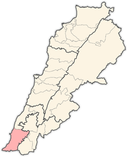
Municipality of Chehour is located in the Kaza of Tyre (sour) one of Mohafazah of South Lebanon kazas (districts). Mohafazah of South Lebanon is one of the eight mohafazats (governorates) of Lebanon. It's 95 kilometers (59.033 mi) away from Beyrouth (Beirut) the capital of Lebanon. Its elevation is 320 meters (1) (1049.92 ft - 349.952 yd) above sea level. Chehour surface stretches for 781 hectares (7.81 km² - 3.01466 mi²)(2).
Name
E. H. Palmer wrote that the name Shuhûr meant "mud walls", or "conspicuous part".[1]
History
In 1596, it was named as a village, Ishur, in the Ottoman nahiya (subdistrict) of Tibnin under the liwa' (district) of Safad, with a population of 48 households, all Muslim. The villagers paid a fixed tax rate of 25% on agricultural products, such as wheat, barley, olive trees, goats and beehives, in addition to occasional revenues and a press for olive oil or grape syrup, and a water mill; a total of 3,067 akçe.[2][3]
In 1881, the PEF's Survey of Western Palestine (SWP) described it as: "A large village with some good houses, containing about 600 Metawileh; it is situated on a hill, and has a well and cisterns in it. There are figs and olives around."[4]
Educational establishment
The table below provides a comparison of public and private schools locally and nationally. It can be used to assess the distribution of students between public and private institutions both locally and nationally. All data provided on education concerning the 2005-2006 school year. Since the publication of more recent figures we will strive to published online.
| Educational establishments | Chehour (2005-2006) | Lebanon (2005–2006) |
|---|---|---|
| Number of Schools | 2 | 2788 |
| Public School | 2 | 1763 |
| Private School | Not available | 1025 |
| Students schooled in the public schools | Not available | 439905 |
| Students schooled in the private schools | Not available | 471409 |
References
People from Chehour
- al-Sayyid Yusuf Sharaf al-Din, father of Abd al-Husayn Sharaf al-Din al-Musawi
Bibliography
- Conder, C.R.; Kitchener, H.H. (1881). The Survey of Western Palestine: Memoirs of the Topography, Orography, Hydrography, and Archaeology. 1. London: Committee of the Palestine Exploration Fund.
- Hütteroth, Wolf-Dieter; Abdulfattah, Kamal (1977). Historical Geography of Palestine, Transjordan and Southern Syria in the Late 16th Century. Erlanger Geographische Arbeiten, Sonderband 5. Erlangen, Germany: Vorstand der Fränkischen Geographischen Gesellschaft. ISBN 3-920405-41-2.
- Palmer, E.H. (1881). The Survey of Western Palestine: Arabic and English Name Lists Collected During the Survey by Lieutenants Conder and Kitchener, R. E. Transliterated and Explained by E.H. Palmer. Committee of the Palestine Exploration Fund.
- Rhode, H. (1979). Administration and Population of the Sancak of Safed in the Sixteenth Century. Columbia University.
External links
- Survey of Western Palestine, Map 2: IAA, Wikimedia commons
- Chehour Localliban: Centre de resource sur le developpement local
- https://web.archive.org/web/20100619010329/http://shohour.org/ (in Arabic)
Capital: Tyre | ||
| Towns and villages |
|  |
| Palestinian refugee camps | ||
| Other | ||