Chandler, Quebec
Chandler is a town in the Gaspésie–Îles-de-la-Madeleine region of Quebec, Canada. It is the second-most populous town on the Gaspé Peninsula after the Town of Gaspé. It was known as Pabos between June 27, 2001 and May 4, 2002.[1]
Chandler | |
|---|---|
City | |
 City of Chandler | |
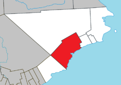 Location within Le Rocher-Percé RCM. | |
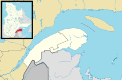 Chandler Location in eastern Quebec. | |
| Coordinates: 48°21′N 64°41′W[1] | |
| Country | |
| Province | |
| Region | Gaspésie–Îles-de-la-Madeleine |
| RCM | Le Rocher-Percé |
| Settled | 1729 |
| Constituted | June 27, 2001 |
| Government | |
| • Mayor | Louisette Langlois |
| • Federal riding | Gaspésie—Îles-de-la-Madeleine |
| • Prov. riding | Bonaventure |
| Area | |
| • Total | 435.50 km2 (168.15 sq mi) |
| • Land | 419.53 km2 (161.98 sq mi) |
| Population (2011)[3] | |
| • Total | 7,703 |
| • Density | 18.4/km2 (48/sq mi) |
| • Pop 2006-2011 | |
| • Dwellings | 3,506 |
| Time zone | UTC−5 (EST) |
| • Summer (DST) | UTC−4 (EDT) |
| Postal code(s) | G0C 1K0 |
| Area code(s) | 418 and 581 |
| Highways | |
| Website | www |
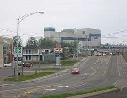
The city is the birthplace of NHL player Mathieu Garon, and Quebec politician Joseph-Léonard Duguay as well as Mary Rose Anna Travers dit "La Bolduc". Chandler's major industries include fishing, manufacturing pulp and paper products, and shipping from the large deep-water wharf.
In addition to Chandler itself, the town's territory also includes the communities of Newport, Grand-Pabos-Ouest, Pabos, Pabos Mills, and Saint-François-de-Pabos.
History

The area was first settled in 1729, making it one of the oldest places on the Gaspé coast. It was known over time as Paboc, Pabo, Pabok, Pabeau, and Pas-bos. In 1815, the final spelling of Pabos was assigned in the Description topographique de la province du Bas Canada (Topographical Description of the Province of Lower Canada). The meaning of this name is uncertain, although there are various theories: from the Mi'kmaq word papôg (meaning "playful waters");[4] a Basque name; from the Spanish pavo; a place in France, home of the first seignoral lord; or from the French words pas[sage] beau (meaning "beautiful passage").[5]
In 1758, the settlement was destroyed by General James Wolfe during his Gulf of St. Lawrence Campaign. It was rebuilt and by 1860, the Parish of Sainte-Adélaïde-de-Pabos was formed. In 1876, it had become the most important civil and religious town in the Gaspésie region, and the place was incorporated as the Municipality of Pabos. 3 years later, its post office opened.[5]
In 1912, Percy Milton Chandler, a Philadelphian manufacturer, built the first pulp and paper mill in the Gaspésie at the mouth of the Grand Pabos River, originally known as Portage-du-Grand-Pabos. By 1916, this village separated from Pabos and was incorporated as the Village Municipality of Chandler. The name Grand-Pabos was also used and in the 1930s, it was even tried to officially rename the village to Grand-Pabos. In 1958, Chandler gained ville (city) status.[1]
On June 27, 2001, the municipalities of Newport, Pabos, Pabos Mills, and Saint-François-de-Pabos, as well as the City of Chandler, were merged to form the new City of Pabos, renamed to Chandler on May 4, 2002.[1]
Demographics
Population
| Canada census – Chandler, Quebec community profile | |||
|---|---|---|---|
| 2011 | 2006 | ||
| Population: | 7,703 (-2.7% from 2006) | 7,914 (-4.4% from 2001) | |
| Land area: | 419.53 km2 (161.98 sq mi) | 419.50 km2 (161.97 sq mi) | |
| Population density: | 18.4/km2 (48/sq mi) | 18.9/km2 (49/sq mi) | |
| Median age: | 50.7 (M: 50.1, F: 51.5) | 47.3 (M: 45.9, F: 48.2) | |
| Total private dwellings: | 3,506 | 3,556 | |
| Median household income: | $41,440 | $38,500 | |
| References: 2011[6] 2006[7] earlier[8] | |||
| Historical Census Data - Chandler, Quebec[9] | |||||||||||||||||||||||||||||
|---|---|---|---|---|---|---|---|---|---|---|---|---|---|---|---|---|---|---|---|---|---|---|---|---|---|---|---|---|---|
|
|
| |||||||||||||||||||||||||||
(M) merged with municipalities of Newport, Pabos, Pabos Mills and Saint-François-de-Pabos on June 27, 2001. | |||||||||||||||||||||||||||||
Language
| Canada Census Mother Tongue - Chandler, Quebec[9] | ||||||||||||||||||
|---|---|---|---|---|---|---|---|---|---|---|---|---|---|---|---|---|---|---|
| Census | Total | French |
English |
French & English |
Other | |||||||||||||
| Year | Responses | Count | Trend | Pop % | Count | Trend | Pop % | Count | Trend | Pop % | Count | Trend | Pop % | |||||
2011 |
7,600 |
7,195 | 94.67% | 335 | 4.41% | 50 | 0.66% | 20 | 0.26% | |||||||||
2006 |
7,780 |
7,440 | 95.63% | 255 | 3.28% | 10 | 0.13% | 75 | 0.96% | |||||||||
2001 |
2,930 |
2,780 | 94.88% | 110 | 3.75% | 25 | 0.85% | 15 | 0.51% | |||||||||
1996 |
3,260 |
3,000 | n/a | 92.02% | 215 | n/a | 6.60% | 35 | n/a | 1.07% | 10 | n/a | 0.31% | |||||
Attractions
Saint Dominique's Church is a large Roman Catholic church in Newport.
 St. Dominique's Church in Newport
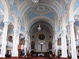 St. Dominique's Church in Newport
See also
- List of cities in Quebec
References
- "Chandler (Ville)" (in French). Commission de toponymie du Québec. Retrieved 2011-12-13.
- "Chandler". Répertoire des municipalités (in French). Ministère des Affaires municipales, des Régions et de l'Occupation du territoire. Archived from the original on 2012-04-07. Retrieved 2011-12-08.
- "Chandler census profile". 2011 Census data. Statistics Canada. Retrieved 2011-12-14.
- Rand, Silas Tertius (1875-01-01). A First Reading Book in the Micmac Language: Comprising the Micmac Numerals, and the Names of the Different Kinds of Beasts, Birds, Fishes, Trees, &c. of the Maritime Provinces of Canada. Also, Some of the Indian Names of Places, and Many Familiar Words and Phrases, Translated Literally Into English. Nova Scotia Printing Company.
- "Pabos (Municipalité)" (in French). Commission de toponymie du Québec. Retrieved 2011-12-13.
- "2011 Community Profiles". 2011 Canadian Census. Statistics Canada. July 5, 2013. Retrieved 2014-01-28.
- "2006 Community Profiles". 2006 Canadian Census. Statistics Canada. March 30, 2011. Retrieved 2011-12-14.
- "2001 Community Profiles". 2001 Canadian Census. Statistics Canada. February 17, 2012.
- Statistics Canada: 1996, 2001, 2006, 2011 census
External links
| Wikivoyage has a travel guide for Chandler (Quebec). |
Adjacent Municipal Subdivisions | |
|---|---|
| Cities | |
|---|---|
| Municipalities | |
| Unorganized Territory | |
| |
| Authority control |
|
|---|