Chalfant, Pennsylvania
Chalfant is a borough in Allegheny County, Pennsylvania, United States. The population was 800 at the 2010 census.[3]
Chalfant, Pennsylvania | |
|---|---|
Borough | |
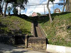 The Parkway Steps, built in 1936. | |
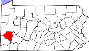
 Location in Allegheny County and the U.S. state of Pennsylvania. | |
| Coordinates: 40°24′36″N 79°50′18″W | |
| Country | United States |
| State | Pennsylvania |
| County | Allegheny |
| Area | |
| • Total | 0.16 sq mi (0.41 km2) |
| • Land | 0.16 sq mi (0.41 km2) |
| • Water | 0.00 sq mi (0.00 km2) |
| Population (2010) | |
| • Total | 800 |
| • Estimate (2018)[2] | 774 |
| • Density | 4,899.37/sq mi (1,890.48/km2) |
| Time zone | UTC-5 (Eastern (EST)) |
| • Summer (DST) | UTC-4 (EDT) |
| FIPS code | 42-12496 |
| Website | chalfantborough-pa |
The borough was named after the Chalfant family of early settlers.[4]
Geography
Chalfant is located at 40°24′36″N 79°50′18″W (40.409968, -79.838285).[5]
According to the United States Census Bureau, the borough has a total area of 0.2 square miles (0.52 km2), all of it land.
Government and Politics
| Year | Republican | Democratic | Third Parties |
|---|---|---|---|
| 2016 | 43% 183 | 52% 220 | 5% 20 |
| 2012 | 44% 174 | 55% 218 | 2% 7 |
Surrounding neighborhoods
Chalfant has three borders, including Wilkins Township from the northeast to southeast, North Braddock to the southwest, and Forest Hills to the northwest.
Demographics
| Historical population | |||
|---|---|---|---|
| Census | Pop. | %± | |
| 1920 | 1,044 | — | |
| 1930 | 1,192 | 14.2% | |
| 1940 | 1,372 | 15.1% | |
| 1950 | 1,381 | 0.7% | |
| 1960 | 1,414 | 2.4% | |
| 1970 | 1,370 | −3.1% | |
| 1980 | 1,119 | −18.3% | |
| 1990 | 959 | −14.3% | |
| 2000 | 870 | −9.3% | |
| 2010 | 800 | −8.0% | |
| Est. 2018 | 774 | [2] | −3.2% |
| Sources:[8][9][10][11][12][13][14] | |||
At the 2000 census there were 870 people in 407 households, including 234 families, in the borough. The population density was 5,498.6 people per square mile (2,099.4/km²). There were 449 housing units at an average density of 2,837.8 per square mile (1,083.5/km²). The racial makeup of the borough was 93.45% White, 3.79% African American, 0.23% Native American, 0.69% Asian, 0.11% Pacific Islander, 0.34% from other races, and 1.38% from two or more races. Hispanic or Latino of any race were 0.46%.[13]
There were 407 households, 21.6% had children under the age of 18 living with them, 40.3% were married couples living together, 11.1% had a female householder with no husband present, and 42.5% were non-families. 37.8% of households were made up of individuals, and 14.3% were one person aged 65 or older. The average household size was 2.14 and the average family size was 2.85.
The age distribution was 18.9% under the age of 18, 7.6% from 18 to 24, 29.4% from 25 to 44, 24.5% from 45 to 64, and 19.7% 65 or older. The median age was 41 years. For every 100 females, there were 105.7 males. For every 100 females age 18 and over, there were 97.2 males.
The median household income was $33,125 and the median family income was $46,471. Males had a median income of $28,889 versus $21,420 for females. The per capita income for the borough was $17,784. About 5.6% of families and 9.1% of the population were below the poverty line, including 17.6% of those under age 18 and 8.7% of those age 65 or over.
References
- "2017 U.S. Gazetteer Files". United States Census Bureau. Retrieved Mar 24, 2019.
- "Population and Housing Unit Estimates". Retrieved February 29, 2020.
- "Race, Hispanic or Latino, Age, and Housing Occupancy: 2010 Census Redistricting Data (Public Law 94-171) Summary File (QT-PL), Chalfant borough, Pennsylvania". United States Census Bureau. Retrieved September 16, 2011.
- Porter, Thomas J. Jr. (May 10, 1984). "Town names carry a little bit of history". Pittsburgh Post-Gazette. p. 1. Retrieved 26 May 2015.
- "US Gazetteer files: 2010, 2000, and 1990". United States Census Bureau. 2011-02-12. Retrieved 2011-04-23.
- EL. "2012 Allegheny County election". Pittsburgh Tribune-Review. Retrieved 15 October 2017.
- EL. "2016 Pennsylvani general election..." Pittsburgh Post-Gazette. Retrieved 15 October 2017.
- "Population of Civil Divisions Less than Counties" (PDF). 1880 United States Census. U.S. Census Bureau. Retrieved 24 November 2013.
- "Population-Pennsylvania" (PDF). U.S. Census 1910. U.S. Census Bureau. Retrieved 22 November 2013.
- "Number and Distribution of Inhabitants:Pennsylvania-Tennessee" (PDF). Fifteenth Census. U.S. Census Bureau.
- "Number of Inhabitants: Pennsylvania" (PDF). 18th Census of the United States. U.S. Census Bureau. Retrieved 22 November 2013.
- "Pennsylvania: Population and Housing Unit Counts" (PDF). U.S. Census Bureau. Retrieved 22 November 2013.
- "U.S. Census website". United States Census Bureau. Retrieved 2008-01-31.
- "Annual Estimates of the Resident Population". U.S. Census Bureau. Archived from the original on 2013-10-19. Retrieved 22 November 2013.
External links
| Wikivoyage has a travel guide for Chalfant, PA. |
| Wikimedia Commons has media related to Chalfant, Pennsylvania. |
Pittsburgh metropolitan area | ||
|---|---|---|
| Counties |  Map of the Pittsburgh Tri-State with green counties in the metropolitan area and yellow counties in the combined area. | |
| Major cities | ||
| Cities and towns 15k–50k (in 2010) | ||
| Airports | ||
| Topics | ||
| ||
| Authority control |
|
|---|