Caypombo, Bulacan
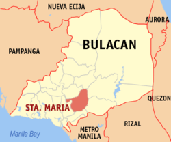
Cay Pombo (PSGC: 031423007) is one of the twenty-four barangays comprising the municipality of Santa Maria, Bulacan, in the Philippines. It is bordered by Barangay Caysio on the south-west, and the south, Pulong Buhangin on the east, Mag-asawang Sapa on the north and Barangay ?? in Pandi on the west.
Barangay Cay Pombo, Sta. Maria, Bulacan | |
|---|---|
Barangay | |
 | |
| Coordinates: 14°49.10′N 120°57.38′E | |
| Country | Philippines |
| Region | Central Luzon |
| Province | Bulacan |
| Municipality | Santa Maria |
| Government | |
| • Type | Barangay |
| • Barangay Captain | Jesus R. Mateo |
| Time zone | GMT (UTC+8) |
| Zip Code | 3022 |
| Area code(s) | 44 |
Geography
Area and location
Cay Pombo is the ?? largest barangay in Santa Maria with a land area of 416.26 hectares or 4.1626 km2, slightly larger than barangay Poblacion.
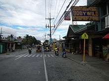
Cay Pombo is located on the north-west portion of Sta. Maria and thirty six kilometers north from Manila.
Climate
The prevailing climatic conditions in the barangay are categorized into two types: dry and wet season.
The annual mean temperature in the area is 27℃. The warmest month is May with a mean temperature of 29.9℃ while the coldest is January at 25.2℃.
The mean annual relative humidity in the Barangay is 77% which is not high. The mean monthly relative humidity is lowest in March at 64% and highest in September at 84%
Demographics
As of the 2007 census, Cay Pombo has a population of 15,698 people with a density of 3,771.20 person per km2.
See also
References
External links
| Wikimedia Commons has media related to Caypombo, Bulacan. |
Malolos (capital) | |
| Municipalities | |
| Component cities | |