Carmel Formation
The Carmel Formation is a geologic formation in the San Rafael Group that is spread across the U.S. states of Wyoming, Utah, Colorado, north east Arizona and New Mexico. Part of the Colorado Plateau, this formation was laid down in the Middle Jurassic during the late Bajocian, through the Bathonian and into the early Callovian stages.[2]
| Carmel Formation Stratigraphic range: Middle Jurassic | |
|---|---|
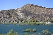 Carmel Formation exposed at Gunlock Reservoir, southwestern Utah | |
| Type | Geological formation |
| Unit of | San Rafael Group |
| Underlies | Entrada Sandstone |
| Overlies | Nugget Sandstone |
| Thickness | From 200 feet (60 m) to 1,000 feet (300 m)[1] |
| Lithology | |
| Primary | Mudstone |
| Other | Sandstone, siltstone, limestone |
| Location | |
| Region | Wyoming, Utah, Colorado, north east Arizona and New Mexico |
| Country | US |
| Type section | |
| Named for | Mount Carmel |
| Named by | Gilluly and Reeside |
| Year defined | 1928 |
Subunits
Members (alphabetical):[2]
- Co-op Creek Limestone Member (UT),
- Crystal Creek Member (UT),
- Homestake Limestone Member (UT*),
- Judd Hollow Member (AZ*, UT*) or Judd Hollow Tongue (AZ*, UT*),
- Kolob Limestone Member (UT) [name violates the 1983 North American Stratigraphic Code],[2]
- Paria River Member (UT*),
- Wiggler Wash Member (UT*),
- Winsor Member (UT*).
(Asterisks mean the name is used by the US Geological Survey).
History of investigation
In 1928 Gilluly and Reeside stated an intent to name the formation after Mount Carmel but did not give a type locality. They noted it as a basal formation in the San Rafael Group in San Rafael Swell, in Emery County, Utah. An overview along with a type locality and source of name was stated by Gregory and Moore in 1931. Mackin revised the formation's description and assigned the Homestake Limestone Member to it in 1954. Harshbarger and others created an overview in 1957. Its eastern areal limits were described by Wright and others in 1962. In 1963, western areal limits along with an overview were completed by Schultz and Wright. Another revision was done by Phoenix in 1963 who also added a Judd Hollow Tongue member. Isotopic dating was conducted by Marvin and others in 1965. The Kolob, Crystal Creek, Paria River, Winsor, and Wiggler Wash members were assigned by Thompson and Stokes in 1970. Areal limits were adjusted by O'Sullivan and Craig in 1973 and again in 1983 by Blakey and others. An overview was completed by Chapman in 1989. Hintze and others conducted isotopic dating and created an overview in 1994.[3]
Paleontological finds
There have been a number of paleontological finds within the Carmel Formation. Among these have been bryozoans, oysters, as well as dinosaur footprints.
Bryozoans
Bryozoans found within the Carmel Formation include seven species of calcareous cyclostome bryozoans as well as a soft-bodied ctenostome bryozoan.[4]
Pictures
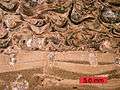 Cross-section of a carbonate hardground encrusted by oysters and bored by bivalves (Gastrochaenolites); Carmel Formation (Middle Jurassic) of southern Utah.
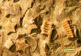 Biosparite/grainstone with crinoid columnals (Isocrinus nicoleti) from the Carmel Formation at Mount Carmel Junction, Utah.
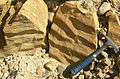 Ripplemarks in a biosparite/grainstone from the Middle Jurassic Carmel Formation, southwestern Utah.
Places found
Geologic Province:[2]
- Black Mesa Basin*
- Capitol Reef National Park
- Great Basin province*
- Green River Basin*
- Paradox Basin*
- Plateau sedimentary province*
- San Juan Basin
- Uinta Basin*
- Uinta Uplift*
References
- "Carmel Formation (in San Rafael Group)". 6 September 2015.
- GEOLEX database entry for Carmel, USGS (viewed 20 March 2006)
- For the whole section, except where noted: GEOLEX database: Summary of Citations for Carmel, USGS
- Taylor, P.D., Wilson, M.A. (1999). "Middle Jurassic Bryozoans from the Carmel Formation of Southwestern Utah". Journal of Paleontology 73: 816-830.