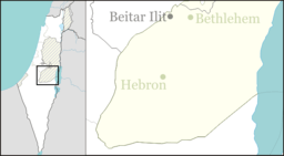
Carmel, Har Hebron
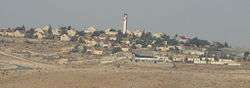
Carmel (Hebrew: כרמל Karmel) is an Israeli settlement in south-east Har Hebron area of the West Bank, close to the Palestinian villages of Umm al-Kheir, who settled there several decades ago after Israel expelled them from the Arad desert, and who purchased the land from residents in the Palestinian village of Yatta.[2] According to David Shulman, Carmel lies on lands appropriated from the Bedouin of that village.[3] It falls under the jurisdiction of the Har Hebron Regional Council and associates ideologically with the Amana settlement movement. In 2018 it had a population of 436.
Carmel כרמל | |
|---|---|
 | |
 Carmel | |
| Coordinates: 31°25′54″N 35°10′58″E | |
| Country | Israel |
| District | Judea and Samaria Area |
| Council | Har Hebron |
| Region | West Bank |
| Affiliation | Amana |
| Founded | 1980 |
| Population (2018)[1] | 436 |
The international community considers Israeli settlements in the West Bank illegal under international law, but the Israeli and US[4] governments dispute this.[5]
Etymology
The name Carmel was chosen due to the moshav's close proximity to the location of Biblical Carmel (Joshua 15:55), the home of Nabal. Carmel is mentioned in 1 Samuel 25:2 as the home of Nabal. The new settlement is expanding, and, according to several commentators, 'continuing to usurp the land of its neighbors, who lived at the site decades before the settlers arrived.'[2]
History
The moshav was founded in 1980, next to the land on which the Hadaleen Bedouin tribe live,[2] as a Nahal military-establishment, and was "civilianized" in 1981.
Reuta Beth midrash was established in 2001[6] which is also a hesder yeshiva.
According to Nicholas Kristof of The New York Times, Carmel is
'a lovely green oasis that looks like an American suburb. It has lush gardens, kids riding bikes and air-conditioned homes. It also has a gleaming, electrified poultry barn that it runs as a business.' Beyond its barbed wire fencing, the Bedouins of Umm al-Kheir in shanties are denied connection to the electricity grid, barns for their livestock and toilets, and all attempts to build permanent dwellings are demolished. Elad Orian, an Israeli human rights activist, noted that the chickens of Carmel's poultry farm get more electricity and water than the Palestinian Bedouin nearby.[7]
Hammerman writes as follows:
Right next to the stately country homes - complete with air-conditioning, drip-irrigation gardens and goldfish ponds - a few extended families including old men, old women and infants live in dwellings made of tin, cloth and plastic siding, though there are a few cinder-block structures, too. They tread on broken, barren ground. They have no running water. They are not connected to the power grid that lights up every settlement and outpost in this remote region. They have no access road.[2]
References
| Wikimedia Commons has media related to Carmel. |
- "Population in the Localities 2018" (XLS). Israel Central Bureau of Statistics. 25 August 2019. Retrieved 26 August 2019.
- Ilana Hammerman, 'West Bank settlement is outdoing its neighboring Bedouin village,' Haaretz 11 November 2011
- David Shulman, ‘Truth and Lies in South Hebron,’ Jewish Quarterly 18 June 2013.'Um al-Khair, a ramshackle collection of tents and huts and simple stone houses and sheep-pens and corrugated shacks that borders, tragically, on the settlement of Carmel in the South Hebron hills. Or rather, historically, Carmel borders on Um al-Khair, since the lands appropriated for the settlement in the early 80s all belonged to the Bedouin goat-herders and farmers who live on this rocky hill..'
- https://www.nytimes.com/2019/11/18/world/middleeast/trump-israel-west-bank-settlements.html
- "The Geneva Convention". BBC News. 10 December 2009. Retrieved 27 November 2010.
- About Archived August 1, 2014, at the Wayback Machine Reuta
- Nicholas Kristof, 'The Two Sides of a Barbed-Wire Fence,', The New York Times 30 June 2010.