Beit Yatir
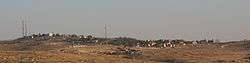
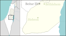
Beit Yatir (Hebrew: בית יתיר), also known as Metzadot Yehuda (Hebrew: מְצָדוֹת יְהוּדָה), is a religious-Zionist Orthodox moshav and Israeli settlement in the southern Hebron Hills of the West Bank. Located on a hill, 900 metres above sea level, near the Green Line, south of Susiya, and close to the Palestinian village of as-Seefer,[2] it falls under the jurisdiction of Har Hebron Regional Council. In 2018, it had a population of 512.[1]
Beit Yatir בית יתיר | |
|---|---|
 | |
 Beit Yatir | |
| Coordinates: 31°22′00″N 35°06′42″E | |
| Country | Israel |
| District | Judea and Samaria Area |
| Council | Har Hebron |
| Region | West Bank |
| Affiliation | Amana |
| Founded | 1979 |
| Population (2018)[1] | 512 |
The ruins of the ancient town of Eshtemoa are nearby.
The international community considers Israeli settlements in the West Bank illegal under international law, but the Israeli and US governments dispute this.[3]
History
Beit Yatir was established in 1979 by students from the Mercaz HaRav Yeshiva. In 1983, the moshav was moved southwest from its original location south of the town of as-Samu to its current location in the Yatir Forest. A visual landmark of the moshav is a high wind turbine.
The social make-up of the moshav residents varies between sabras to immigrants from various countries, including France, Russian, Brazil, and English-speaking countries. The moshav does not require residents to become members of the cooperative.
Education
A Religious Pre-Army Mechina, with several dozen students enrolled, is headed by Rabbi Moshe Hagar.
References
- "Population in the Localities 2018" (XLS). Israel Central Bureau of Statistics. 25 August 2019. Retrieved 26 August 2019.
- Weibel, Catherine Seam Zone keeps Palestinian children in limbo, disrupting education UNICEF 21 May 2012]
- "The Geneva Convention". BBC News. 10 December 2009. Retrieved 27 November 2010.