Cabras Island
Cabras Island is a long finger of low-lying reef and land which forms the northern shore of Apra Harbor, Guam. Tourists come to the island for snorkeling and hiking. [1]
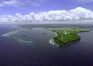 Cabras Island is the low-lying land to the left in this view of Apra Harbor's mouth | |
| Geography | |
|---|---|
| Location | Pacific Ocean |
| Coordinates | |
| Administration | |
| Additional information | |
| Time zone |
|
History
The island's length has been extended artificially by the Glass Breakwater, named for Captain Henry Glass, who captured Guam for the United States in 1898 during the Spanish–American War. A road extends to the breakwater, though this is sometimes closed for security reasons during visits by ships.
The opposite coast of the harbor is formed by the Orote Peninsula, which houses Naval Base Guam and Point Udall (formerly Orote Point), mainland Guam's westernmost extremity.
Further reading
- Bendure, G. & Friary, N. (1988) Micronesia: A Travel Survival Kit. South Yarra, VIC: Lonely Planet.
References
- "Beachside beauty: Check out some of Guam's best beaches". guam.stripes.com. Stars and Stripes. Retrieved 14 January 2020.
Hagåtña (capital) | |
| Topics |
|
| Islands | |
| Villages | |
| Peaks |
|
| Healthcare | |
This article is issued from Wikipedia. The text is licensed under Creative Commons - Attribution - Sharealike. Additional terms may apply for the media files.