Butt of Lewis Lighthouse
Butt of Lewis Lighthouse, designed by David Stevenson, was built at Butt of Lewis to aid shipping in the 1860s. Unusual for a lighthouse in Scotland, it is constructed of red brick, and is unpainted. The station was automated in 1998, one of the last to be converted. A modern differential GPS base station has now been sited on a nearby hill to further aid navigation. This hill was also the site for a Lloyd's Signal Station from the 1890s.
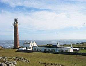 Butt of Lewis Lighthouse | |
 Outer Hebrides | |

| |
| Location | Butt of Lewis Lewis Outer Hebrides Scotland |
|---|---|
| Coordinates | 58°30′55.7″N 6°15′39.2″W |
| Year first constructed | 1862 |
| Automated | 1998 |
| Construction | brick tower |
| Tower shape | tapered cylindrical tower with balcony and lantern |
| Markings / pattern | brick unpainted tower, black lantern, ochre trim |
| Tower height | 37 metres (121 ft) |
| Focal height | 52 metres (171 ft) |
| Range | 25 nautical miles (46 km; 29 mi) |
| Characteristic | Fl W 5s. |
| Admiralty number | A3968 |
| NGA number | 3820 |
| ARLHS number | SCO-027 |
| Managing agent | Northern Lighthouse Board[1] [2] |
| Heritage | category A listed building |
The road to the lighthouse passes a sheltered cove called Port Stoth. Agricultural lazy beds are also visible along the coast. The Butt of Lewis features some of the oldest rocks in Europe, having been formed in the Precambrian period up to 3000 million years ago. Following the coast southwest from the lighthouse there is a natural arch called the "Eye of the Butt" (Scottish Gaelic: Toll a’ Ròigh). It can be best viewed from the Habost machair.
See also
References
- Butt Of Lewis (Rubha Robhanais) The Lighthouse Directory. University of North Carolina at Chapel Hill. Retrieved 18 May 2016
- Butt of Lewis Northern Lighthouse Board. Retrieved 18 May 2016
External links
| Wikimedia Commons has media related to Butt of Lewis Lighthouse. |
- Butt of Lewis history by the Northern Lighthouse Board
- Panoramas of the Butt of Lewis Lighthouse (QuickTime required)
- Northern Lighthouse Board